
A waterfall is an area where water flows over a vertical drop or a series of steep drops in the course of a stream or river. Waterfalls also occur where meltwater drops over the edge of a tabular iceberg or ice shelf.

The river Ticino is the most important perennial left-bank tributary of the Po. It has given its name to the Swiss canton through which its upper portion flows.

The Engadin or Engadine is a long high Alpine valley region in the eastern Swiss Alps in the canton of Graubünden in southeasternmost Switzerland with about 25,000 inhabitants. It follows the route of the Inn from its headwaters at Maloja Pass in the southwest running roughly northeast until the Inn flows into Austria, one hundred kilometers downstream. The En/Inn subsequently flows at Passau into the Danube, making it the only Swiss river to drain into the Black Sea. The Engadine is protected by high mountain ranges on all sides and is famous for its sunny climate, beautiful landscapes and outdoor activities.

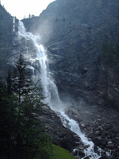
The Reichenbach Falls are a waterfall cascade of seven steps on the stream called Rychenbach in the Bernese Oberland region of Switzerland. They drop over a total change of altitude of about 250 metres (820 ft). At 110 metres (360 ft), the Grand Reichenbach Fall, the upper one, is by far the largest one and one of the higher waterfalls in the Alps and among the forty highest in Switzerland. The Rychenbach loses 290 metres (950 ft) of height from the top of the falls to the valley floor of the Haslital. Today, a hydro-electric power company harnesses the flow of the Reichenbach Falls during certain times of year, reducing its flow.
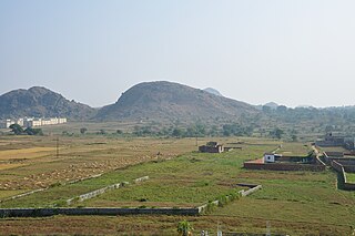
The Chota Nagpur Plateau is a plateau in eastern India, which covers much of Jharkhand state as well as adjacent parts of Odisha, West Bengal and Chhattisgarh. The Indo-Gangetic plain lies to the north and east of the plateau, and the basin of the Mahanadi River lies to the south. The total area of the Chota Nagpur Plateau is approximately 65,000 square kilometres (25,000 sq mi).
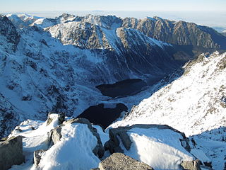
Tatra National Park is a National Park located in the Tatra Mountains in Tatra County, in the Lesser Poland Voivodeship—Małopolska region, in central-southern Poland. The Park has its headquarters in the town of Zakopane.
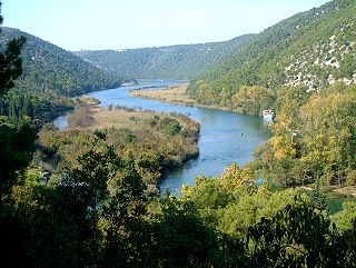
Krka is a river in Croatia's Dalmatia region, known for its numerous waterfalls. It is 73 km (45 mi) long and its basin covers an area of 2,088 km2 (806 sq mi). It was known in ancient Greek as Kyrikos, or may be also as Catarbates by the ancient Greeks, it was known to the ancient Romans as Titius, Corcoras, or Korkoras.
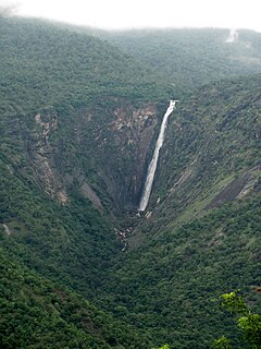
Thalaiyar Falls, also known as Rat Tail Falls is located in the Devadanapatti of Theni District, Tamil Nadu State, South India. It is 975 ft (297 m) tall and is the highest waterfall in Tamil Nadu, the sixth highest waterfall in India and the 267th highest in the world.
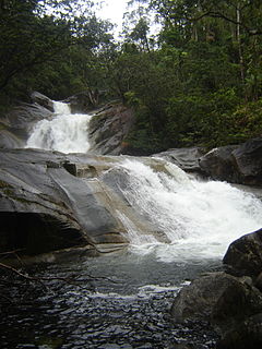
The Josephine Falls is a tiered cascade waterfall on the Josephine Creek located in Wooroonooran, Cairns Region in the Far North region of Queensland, Australia.

The Dip Falls, a cascade waterfall over cubic-basalt formed rocks on the Dip River, is located in Mawbanna in the North West region of Tasmania, Australia.
The Engstligen Falls near Adelboden in the Bernese Highlands consists of two waterfalls, Engstligen Fall I & II of heights of 97 metres (318 ft), and 165 metres (541 ft), respectively). They are listed in the Swiss Inventory of Landscapes of National Significance.

The Mera is a river in Switzerland and Italy. Its source is near the Piz Mungiroi, in the Grisons, Switzerland. First, it flows east in the direction to Maloja Pass, then turns west through the Val Bregaglia and crosses the border to Italy in Castasegna (Dogana). It is joined by the Acquafraggia close to Piuro, and then turns south at Chiavenna, just before it receives the river Liro from the right at Prata Camportaccio. The Mera ends in Lake Como, near Sorico in the Province of Como.

Piz Badile is a mountain of the Bregaglia range in the Swiss canton of Graubünden and the Italian region of Lombardy. The border between the two countries runs along the summit ridge. Its north-east face, overlooking the Swiss Val Bregaglia near Soglio, is considered one of the six great north faces of the Alps.

Cima di Castello is a mountain of the Bregaglia Range, located on the border between Italy and Switzerland. With a height of 3,379 metres (11,086 ft) above sea level, it is the second highest mountain in the Bregaglia Range. Its summit lies between the valleys of the Albigna and Forno Glacier and the valley of Val Mello.

Salt Creek Falls is a cascade and plunge waterfall on Salt Creek, a tributary of the Middle Fork Willamette River, that plunges into a gaping canyon near Willamette Pass in the Willamette National Forest, near Oakridge, Oregon. The waterfall is notable for its main drop of 286 feet (87 m) which makes it the third highest plunge waterfall in Oregon after Multnomah Falls and Watson Falls the second highest, which was re-measured in 2009 and found to be 293 feet rather than an earlier measurement of 272 feet passing Salt Creek Falls. The pool at the bottom of the waterfall is 20 metres (66 ft) deep.

Khao Phanom Bencha National Park is a national park in Krabi Province, Thailand. The park is named for Khao Phanom Bencha mountain and protects an area of virgin rainforest and rare wildlife.

The Ingalalla Waterfalls, also known as Ingalalla Falls, is a cascade waterfall in the Australian state of South Australia, located in the locality of Hay Flat within the District Council of Yankalilla, on an unnamed creek on the Fleurieu Peninsula.

The Dandongadale River, a perennial river of the North-East Murray catchment of the Murray-Darling basin, is located in the alpine region of Victoria, Australia. It flows from the northern slopes of the Alpine National Park in the Australian Alps, joining with the Buffalo River in remote national park territory.

The border between the modern states of Switzerland and Italy extends for 744 kilometres (462 mi), from the French-Swiss-Italian tripoint at Mont Dolent in the west to the Austrian-Swiss-Italian tripoint near Piz Lad in the east. Much of the border runs across the High Alps, rising above 4,600 metres (15,100 ft) as it passes east of Dufourspitze, but it also descends to the lowest point in Switzerland as it passes Lago Maggiore at below 200 metres (660 ft).

 Waterfall called Cascade Acquafraggia. From 2015-07. With surrounding
 Waterfall called Cascade Acquafraggia. From 2015-07. Closeup
 Acquafraggia waterfall view from the top

