Related Research Articles

In aviation, instrument flight rules (IFR) is one of two sets of regulations governing all aspects of civil aviation aircraft operations; the other is visual flight rules (VFR).
Air traffic control (ATC) is a service provided by ground-based air traffic controllers who direct aircraft on the ground and through a given section of controlled airspace, and can provide advisory services to aircraft in non-controlled airspace. The primary purpose of ATC worldwide is to prevent collisions, organize and expedite the flow of air traffic, and provide information and other support for pilots. In some countries, ATC plays a security or defensive role, or is operated by the military.

In aviation, the instrument landing system (ILS) is a precision radio navigation system that provides short-range guidance to aircraft to allow them to approach a runway at night or in bad weather. In its original form, it allows an aircraft to approach until it is 200 feet (61 m) over the ground, within a 1⁄2 mile (800 m) of the runway. At that point the runway should be visible to the pilot; if it is not, they perform a missed approach. Bringing the aircraft this close to the runway dramatically increases the range of weather conditions in which a safe landing can be made. Other versions of the system, or "categories", have further reduced the minimum altitudes, runway visual ranges (RVRs), and transmitter and monitoring configurations designed depending on the normal expected weather patterns and airport safety requirements.
Aviation is the design, development, production, operation, and use of aircraft, especially heavier-than-air aircraft. Articles related to aviation include:

Airspace is the portion of the atmosphere controlled by a country above its territory, including its territorial waters or, more generally, any specific three-dimensional portion of the atmosphere. It is not the same as aerospace, which is the general term for Earth's atmosphere and the outer space in its vicinity.
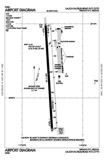
Laughlin/Bullhead International Airport is a public use airport located 1.15 miles north of the central business district of Bullhead City, in Mohave County, Arizona, United States. It is owned by Mohave County. The airport is across the Colorado River and one block away from Laughlin, Nevada. Many of the rooms at Laughlin's casino-hotels offer a view of the airport. It was named 2011 Airport of the Year by the Arizona Department of Transportation.
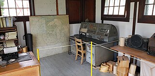
A flight service station (FSS) is an air traffic facility that provides information and services to aircraft pilots before, during, and after flights, but unlike air traffic control (ATC), is not responsible for giving instructions or clearances or providing separation. They do, however, relay clearances from ATC for departure or approaches. The people who communicate with pilots from an FSS are referred to as flight service specialists.

The Canada Flight Supplement (CFS) is a joint civil/military publication and is a supplement of the Aeronautical Information Publication. It is the nation's official airport directory. It contains information on all registered Canadian and certain Atlantic aerodromes and certified airports.
The Airport/Facility Directory, now identified as Chart Supplement in the U.S., is a pilot's manual that provides comprehensive information on airports, large and small, and other aviation facilities and procedures.

In air traffic control, an area control center (ACC), also known as a center or en-route center, is a facility responsible for controlling aircraft flying in the airspace of a given flight information region (FIR) at high altitudes between airport approaches and departures. In the US, such a center is referred to as an air route traffic control center (ARTCC).

Olympia Regional Airport is a public use airport located four nautical miles (7 km) south of the central business district of Olympia, a city in Thurston County and the capital of the U.S. state of Washington. It is owned by the Port of Olympia. It is about one mile (1.6 km) east of Interstate 5, actually within the boundaries of the city of Tumwater which is south of and adjacent to Olympia. The airport was identified in the Washington State Department of Transportation Long Term Aviation Study as a field that could potentially serve to relieve Seattle-Tacoma International Airport of increasing congestion.
In aviation, a standard terminal arrival route or standard terminal arrival (STAR) is a published flight procedure followed by aircraft on an instrument flight rules (IFR) flight plan just before reaching a destination airport.
Iowa City Municipal Airport, is two miles southwest of downtown Iowa City, in Johnson County, Iowa. It is the oldest civil airport west of the Mississippi River still in its original location.
Leesburg Executive Airport at Godfrey Field is a town-owned public-use airport located three nautical miles south of the central business district of Leesburg, a town in Loudoun County, Virginia, United States.
An aeronautical chart is a map designed to assist in the navigation of aircraft, much as nautical charts do for watercraft, or a roadmap does for drivers. Using these charts and other tools, pilots are able to determine their position, safe altitude, best route to a destination, navigation aids along the way, alternative landing areas in case of an in-flight emergency, and other useful information such as radio frequencies and airspace boundaries. There are charts for all land masses on Earth, and long-distance charts for trans-oceanic travel.

Virginia Tech Montgomery Executive Airport is a public airport named for nearby Virginia Tech and located three miles (5 km) south of the central business district of Blacksburg, a town in Montgomery County, Virginia, United States.
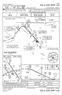
Approach plates are the printed charts of instrument approach procedures that pilots use to fly instrument approaches during instrument flight rules (IFR) operations. Each country maintains its own instrument approach procedures according to International Civil Aviation Organization (ICAO) standards.

Washington County Airport is three miles (5 km) southwest of Washington in South Franklin Township, Pennsylvania. It is owned and operated by Washington County and is in the Pittsburgh metropolitan area.
The National Airspace System (NAS) is the airspace, navigation facilities and airports of the United States along with their associated information, services, rules, regulations, policies, procedures, personnel and equipment. It includes components shared jointly with the military. It is one of the most complex aviation systems in the world, and services air travel in the United States and over large portions of the world's oceans.
AirNav Systems is a Tampa-based global flight tracking and data services company founded in 2001. The company operates a flight tracking website and mobile app called Radarbox which offers worldwide tracking of commercial and general aviation flights. AirNav Systems also owns and operates a ground-based ADS-B tracking network that is supported by over 20,000 active volunteer ADS-B data feeders from over 180 countries. The company's real-time tracking and data services are also used by 25,000 aviation related businesses, government agencies, airlines, media channels and airports in over 60 countries.