All Saints' Church, Wing

Last updated

All Saints' Church, Wing AllSaintsChurchWing-2.jpg
All Saints' Church, Wing

All Saints' Church in Wing, Buckinghamshire, is a Grade I listed parish church. Its masonry was largely built in the 8th to 11th centuries during the Anglo-Saxon period, making it one of the oldest surviving churches in England. [1]

Contents

Wing is located 5 km southwest of Leighton Buzzard and 12 km northeast of Aylesbury. The church itself is located on the outskirts west of the town centre.

The church was the location of a music video of Libera. [2]

History

The history of Wing dates back to the 7th or 8th century; the place name originally meant "The Settlement of Withun's People". The first missionaries appeared at the beginning of the second half of the 7th century and the region was Christianized from Aylesbury. The first mention of Wing comes from the period between 966 and 975. The first written mention of the church comes shortly after the Norman Conquest in 1066 and concerned a priest named Goldric, who remained in the possession of the church and his land even after the Norman Conquest.

Anglo-Saxon era

Anglo-Saxon window on the east wall AllSaintsChurchWing-5.jpg
Anglo-Saxon window on the east wall

Parts of the church preserved from Anglo-Saxon times are the apse and the underlying crypt, the north wall of the church and the pillars. The crypt and the apse above it come from different periods: The oldest part, three niches and windows in the crypt, are from the eighth century. The apse above dates back to the ninth century and is one of the finest examples of ninth-century architecture and the only fully preserved Anglo-Saxon apse in England. From the Anglo-Saxon period also comes the 10.6 metre high three-nave church with the exception of the outer wall of the southern aisle. The triumphal arch between the apse and the nave probably dates from the time of the first renovation in the 9th century. The only Anglo-Saxon window is in the wall of the eastern gable above the choir.

From the Norman Conquest to the Reformation

Gable above the southern entrance AllSaintsChurchWing-10.jpg
Gable above the southern entrance
Ceiling in nave AllSaintsChurchWing-6.jpg
Ceiling in nave

After the Norman conquest of England in 1066, oversight of the church was given to the Benedictine monastery of St. Nicholas in Angers, possibly in the hope that they would establish a priory. However, action was limited to the hiring of a sexton to collect revenues. From 1216, the church's revenues were used to pay for the position of a vicar and from that time the church had the status of a parish church.

In 1416, as a consequence of the Hundred Years War between England and France, the church passed to the Priory of St. Mary de Pre at St Albans. From the middle of the 13th century until the end of the 15th century, the preservation of the church was the responsibility of the secular Lord of Wing and Ascott, who acted as patron of the church.

The church underwent changes in the so-called Decorated Style especially in the first half of the 14th century until the year of plague in 1329. The largest structural changes to the structure of the church took place in the 15th century in the Perpendicular style. The most striking completion of the 15th century was the construction of the massive bell tower, a landmark visible from a great distance. Six bells hang in the tower, four of them dating from the 17th century. They were cast between 1638 and 1654 by the "Knight family's bell foundry" in Reading. The oak bell chair dates from 1654.

From the 14th century come several glass windows, including a coronation of Mary. From 14th and 15th century, respectively, originate the two entrance buildings in the south and north of the church as well as the doorways in them. The doorway in the southern entrance are decorated with coats of arms, lions and other symbols associated with the patron saints of the church. Also from the 15th century is the baptismal font still in use today. The most important work of art left in the church by the 15th century is the wooden ceiling. Below the gable is a series of excellently carved angels with outstretched wings. The edge of the ceiling is decorated by a variety of figures such as kings, queens, musicians and devils.

The church in the post-Reformation period

Tomb of Sir William Dormer AllSaintsChurchWing-13.jpg
Tomb of Sir William Dormer

The Reformation in England began in about 1530 when Henry VIII separated the English Church from the papacy. Significant for Wing was the abolition of the monasteries, since 1528, the Priory of St. Mary de Pre, to which Wing still belonged, was dissolved. The rights of the Priory were acquired by Robert Dormer, 1st Baron Dormer. The Dormers lived in the Manor of Ascott Hall on the outskirts of Wing, acquired the title Earl of Carnarvon in 1628 and were Wing's most important family until the beginning of the 18th century. Diverse members of the Dormer family are buried in the church, mainly at the eastern end of the northern aisle. Particularly impressive are the tombs for Sir Robert Dormer (died 1552), Sir William Dormer (died 1575) and family and Robert Dormer, 1st Baron Dormer (died 1616) and family.

The church is home to a series of 19th-century stained glass windows and a Walker organ dating from 1864, placed in 2002 on a new gallery in the base of the tower.

Related Research Articles

<span class="mw-page-title-main">Anglo-Saxon architecture</span> Period of architecture in England from the mid-5th century until 1066

Anglo-Saxon architecture was a period in the history of architecture in England from the mid-5th century until the Norman Conquest of 1066. Anglo-Saxon secular buildings in Britain were generally simple, constructed mainly using timber with thatch for roofing. No universally accepted example survives above ground. Generally preferring not to settle within the old Roman cities, the Anglo-Saxons built small towns near their centres of agriculture, at fords in rivers or sited to serve as ports. In each town, a main hall was in the centre, provided with a central hearth.

Monks Risborough is a village and ecclesiastical parish in Buckinghamshire, England, lying between Princes Risborough and Great Kimble. The village lies at the foot of the northern scarp of the Chiltern Hills. It is 8 miles (13 km) south of the county town of Aylesbury and 9.5 miles (15.3 km) north of High Wycombe, on the A4010 road.

<span class="mw-page-title-main">Ascott, Buckinghamshire</span> Human settlement in England

Ascott is a hamlet and country house in the parish of Wing, Buckinghamshire, England. The hamlet lies completely within the boundary of the Ascott Estate; it is home to many of the estate and house staff.

<span class="mw-page-title-main">Wing, Buckinghamshire</span> Village in Buckinghamshire, England

Wing, known in antiquated times as Wyng, is a village and civil parish in east Buckinghamshire, England. The village is on the main A418 road between Aylesbury and Leighton Buzzard. It is about 8 miles (13 km) north-east of Aylesbury, 3 miles (5 km) west of Leighton Buzzard, and 12 miles (19 km) south of Milton Keynes.

<span class="mw-page-title-main">Wulfstan (died 1095)</span> 11th-century Bishop of Worcester and saint

Wulfstan was Bishop of Worcester from 1062 to 1095. He was the last surviving pre-Conquest bishop. Wulfstan is a saint in the Western Christian churches.

<span class="mw-page-title-main">Chadlington</span> Human settlement in England

Chadlington is a village and civil parish in the Evenlode Valley about 3 miles (5 km) south of Chipping Norton, Oxfordshire. The village has four neighbourhoods: Brookend, Eastend, Greenend and Westend.

<span class="mw-page-title-main">Norman architecture</span> Styles of Romanesque architecture developed by the Normans

The term Norman architecture is used to categorise styles of Romanesque architecture developed by the Normans in the various lands under their dominion or influence in the 11th and 12th centuries. In particular the term is traditionally used for English Romanesque architecture. The Normans introduced large numbers of castles and fortifications including Norman keeps, and at the same time monasteries, abbeys, churches and cathedrals, in a style characterised by the usual Romanesque rounded arches and especially massive proportions compared to other regional variations of the style.

York had around 45 parish churches in 1300. Twenty survive, in whole or in part, a number surpassed in England only by Norwich, and 12 are used for worship. This article consists of a list of medieval churches which still exist in whole or in part, and a list of medieval churches which are known to have existed in the past but have been completely demolished.

<span class="mw-page-title-main">Old Minster, Winchester</span> Former Anglo-Saxon cathedral for the diocese of Wessex

The Old Minster was the Anglo-Saxon cathedral for the English diocese of Wessex and then Winchester from 660 to 1093. It stood on a site immediately north of and partially beneath its successor, Winchester Cathedral.

<span class="mw-page-title-main">St Mary's Priory Church, Deerhurst</span> Church in England, UK

St Mary's Priory Church, Deerhurst, is the Church of England parish church of Deerhurst, Gloucestershire, England. Much of the church is Anglo-Saxon. It was built in the 8th century, when Deerhurst was part of the Anglo-Saxon kingdom of Mercia. It is contemporary with the Carolingian Renaissance on mainland Europe, which may have influenced it.

<span class="mw-page-title-main">Holy Trinity Church, Westbury on Trym</span> Church in Bristol, England

Holy Trinity Church is a Church of England parish church in Westbury-on-Trym, Bristol, England.

<span class="mw-page-title-main">St Chad's Church, Poulton-le-Fylde</span> Church in Lancashire, England

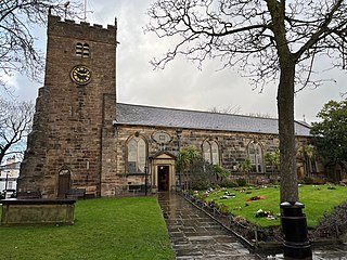
St Chad's Church is an Anglican church in Poulton-le-Fylde, Lancashire, England. It is an active parish church in the Diocese of Blackburn and the archdeaconry of Lancaster. It is recorded in the National Heritage List for England as a designated Grade II* listed building. A church on the site was built no later than the 11th century and may have existed prior to the Norman conquest of England. The tower dates from the 17th century, and much of the remainder of the building from a major renovation in the 18th century, although some of the fabric of the original structure remains. Further renovation and additions took place in the 19th, 20th and 21st centuries.

Repton Abbey was an Anglo-Saxon Benedictine abbey in Derbyshire, England. Founded in the 7th century, the abbey was a double monastery, a community of both monks and nuns. The abbey is noted for its connections to various saints and Mercian royalty; two of the thirty-seven Mercian Kings were buried within the abbey's crypt. The abbey was abandoned in 873, when Repton was overrun by the invading Great Heathen Army.

<span class="mw-page-title-main">Church of St Mary and All Saints, Whalley</span> Church in Lancashire, England

The Church of St Mary and All Saints is an Anglican church in the village of Whalley, Lancashire, England. It is an active parish church in the Diocese of Blackburn. A church probably existed on the site in Anglo-Saxon times and the current building dates from the 13th century. It is recorded in the National Heritage List for England as a designated Grade I listed building.

<span class="mw-page-title-main">St Matthew's Church, Langford</span> Church in Oxfordshire , United Kingdom

The Parish Church of Saint Matthew, Langford is the Church of England parish church of Langford, a village in West Oxfordshire about 3 miles (5 km) northeast of Lechlade in neighbouring Gloucestershire.

<span class="mw-page-title-main">St Mary's Church, Chickney</span> Church in Essex, England

St Mary's Church is a redundant Anglican church in the parish of Chickney, Essex, England. It is recorded in the National Heritage List for England as a designated Grade I listed building, and is under the care of the Churches Conservation Trust.

<span class="mw-page-title-main">St Margaret's Church, Hales</span> Church in Norfolk, England

St Margaret's Church is a redundant Anglican church in the village of Hales, Norfolk, England. It is recorded in the National Heritage List for England as a designated Grade I listed building, and is under the care of the Churches Conservation Trust. The church stands in open fields to the south of the village and to the east of the A146 road.

<span class="mw-page-title-main">St Bartholomew's Church, Penn</span> Church in West Midlands, England

St Bartholomew's Church is in Penn, a district of Wolverhampton, West Midlands, England. It is an active Anglican parish church in the deanery of Trysull, the archdeaconry of Walsall, and the diocese of Lichfield. Its benefice is united with that of St Anne, Lower Penn. The church is recorded in the National Heritage List for England as a designated Grade II* listed building.

<span class="mw-page-title-main">Church of St John the Baptist, Royston, South Yorkshire</span> Church in Royston, England

The Church of St John the Baptist is the parish church in the village of Royston in South Yorkshire, England. It is a Church of England church in the Diocese of Leeds. The building is Grade I listed and was built in the 12th century AD.

<span class="mw-page-title-main">All Saints Church, Segenhoe</span> Ruined church in Segenhoe, Bedfordshire, England

All Saints Church, Segenhoe is a ruined medieval church located near the village of Ridgmont, Bedfordshire. It contains architectural details that range from the 11th century when it was first built to the 19th century. The church was abandoned in 1855 when a larger church was built in Ridgmont. The cemetery continues to be used for burials. The church is managed by Central Bedfordshire Council. All Saints Church is designated a scheduled Ancient Monument.

References

  1. Historic England. "Church of All Saints, Wing (1320141)". National Heritage List for England . Retrieved 10 August 2019.
  2. Vespera (initially known as Te lucis or Before the Ending; video; solo: Steven Geraghty and Ben Crawley). Youtube, 2006.

51°53′41.5″N0°43′20″W / 51.894861°N 0.72222°W / 51.894861; -0.72222