Alnwick/Haldimand

Last updated

Alnwick/Haldimand
Township of Alnwick/Haldimand
Alnwick-Haldimand ON.JPG
Township hall in Grafton
Nickname: 
The Township between the Lakes
Northumberland locator map 2021.svg
Red pog.svg
Alnwick/Haldimand
Canada Southern Ontario location map 2.png
Red pog.svg
Alnwick/Haldimand
Coordinates: 44°05′N78°02′W / 44.083°N 78.033°W / 44.083; -78.033
CountryFlag of Canada (Pantone).svg  Canada
ProvinceFlag of Ontario.svg  Ontario
County Northumberland
Incorporated2000
Government
  TypeTownship
  MayorJohn Logel
  Federal riding Northumberland-Peterborough South
  Prov. riding Northumberland—Peterborough South
Area
[1]
  Land398.45 km2 (153.84 sq mi)
Population
 (2016) [1]
  Total6,869
  Density17.25/km2 (44.7/sq mi)
Time zone UTC-5 (EST)
  Summer (DST) UTC-4 (EDT)
Postal Code
K0K
Area codes 905, 705, 289 and 365
Website www.alnwickhaldimand.ca
Grafton Grafton ON.JPG
Grafton

The Township of Alnwick/Haldimand is a township in central Ontario, Canada, in Northumberland County, situated between Lake Ontario and Rice Lake. It was formed in 2001 by the merger of Alnwick Township in the north and Haldimand Township in the south. [2] Alderville First Nation is an autonomously governed First Nation contained within the township boundaries, in two non-contiguous sections along County Roads 45 and 18.

Contents

History

Alnwick Township

Alnwick Township was originally surveyed in 1795 when twenty-four lots were laid out on the first concession. It was named for Alnwick in Northumberland, England. The first crown grants were issued in 1798 and other surveys would follow in subsequent years. [3] The township's first residents were made up of United Empire Loyalists, attracted by large unencumbered land grants, sometimes in the thousands of acres. [4] In 1835, 3,600 acres of land along the first and second concessions were set aside as an Indian settlement. Shortly after, the Indian Band from Grape Island was moved into this settlement and a school and church were built at Alderville. [3] The first council meeting was held in 1845 at Alderville School. The Alnwick/Haldimand Township building located in Grafton was built in 1858. Prior to its construction, Township Council meetings were held at local taverns or the residences of council members. [5]

Haldimand Township

Haldimand Township was formed in 1791 and was named in honour of Sir Frederick Haldimand  – a British general who served as Governor-in-Chief of Canada between 1778 and 1796. [6] By 1804, there were 356 settlers in Haldimand Township making it the second most populous township in the region after Hamilton Township to the West. [6] The town hall was constructed in 1860. However, in order to be as accessible to as many rate payers as possible, council held frequent meetings in public buildings in towns across the Township. On one occasion following a fire that destroyed the Centreton Community Centre in 1943, a council meeting was held at the private residence of former reeve Stanley McBride. [6]

Municipal restructuring

As part of provincial initiatives in the late 1990s, the Government of Ontario pursued a policy of municipal amalgamations to rationalize municipal levels of government services and "reduc[e] government entanglement and bureaucracy with an eye to eliminating waste and duplication as well as unfair downloading by the province". [7] On June 9, 1999, an order from the Ontario Minister of Municipal Affairs for the amalgamation of Alnwick Township and Haldimand Township into a single Township of Alnwick/Haldimand received Royal assent. The amalgamation came into effect on January 1, 2001. [2]

Geography

Geographical features

Alnwick/Haldimand is part of the Oak Ridges Moraine: a significant land form in Ontario.

31.3 km2 of the Cobourg Creek watershed runs through the Township. The majority of this area is located within the Oak Ridges Moraine. [8] The Creek supports a diverse ecosystem including forests, meadows and wetlands. Numerous species inhabit the Creek including brown trout, rainbow trout, scuplins and darters. Migratory Chinook Salmon spawn in the creek and Atlantic Salmon are being stocked as part of a provincial initiative to return these native fish to Lake Ontario. [8]

The Ganaraska Forest is an 11,000-acre forest located in the Township. It is one of the largest blocks of forested land in southern Ontario. [9] The Millvalley Hills Forest is a 297 hectare forest located within the Township of Alnwick/Haldimand. The dominant trees species are red and white pine, and red and white oak, however red oak dominates the area. [8]

The Harwood Road Wetland is a class 2 provincially significant wetland located in the Township of Hamilton and the Township of Alnwick/Haldimand. 95.9 hectares in size, the wetland is 95% swamp, and 0.5% marsh. [8]

Communities

The township comprises the communities of Burnley, Carmel, Centreton, Dunnette Landing, Fenella, Grafton, The Gully, Lakeport, Little Germany, McCracken Landing, Oak Heights, Robins Landing, Roseneath, Vernonville and Wicklow.

Alderville First Nation

The Alderville First Nation is an Anishinaabe First Nation located in southern Ontario, Canada. As of September 2008, Alderville First Nation had 1007 registered band members, of which their on-Reserve population was only 313 people, meaning the majority of their registered population live outside the reserve (off-reserve) in neighbouring communities. [10]

The First Nation have reserved for themselves two areas. Their main reserve, the Alderville First Nation (formerly designated as Alderville Indian Reserve 37 by Indian and Northern Affairs Canada), is located near the south shores of Rice Lake in Ontario ( 44°11′N78°04′W / 44.183°N 78.067°W / 44.183; -78.067 ). It consists of six non-contiguous areas within the Alnwick/Haldimand Township approximately 30 kilometres (19 mi) north of Cobourg, and occupies a total area of 1,199.8 hectares (2,965 acres). They also maintain a smaller parcel of land on nearby Sugar Island, the 40.5 hectares (100 acres) Sugar Island 37A Indian Reserve ( 44°13′N78°8.25′W / 44.217°N 78.13750°W / 44.217; -78.13750 ). [11] It has been home to the Mississauga division of the Anishinaabe (Ojibwa) Nation since the mid-1830s. [12]

Economy

The township is rural based with agriculture being the largest contributor to the general economy. Grain, cash crops, milk, livestock, vineyards and apple farming are all viable in the area. [4] The top industries for the employed labour force are manufacturing, public administration and construction. Approximately 15% of workers were self-employed as of the 2011 Census of Canada. [13]

Tourism is also a contributor to the local economy. Venues such as Golden Beach Resort and Ste. Anne's Country Inn & Spa are among the top private sector employers in Northumberland County. [14] Outdoor activities including hiking, kayaking, snowmobiling, fishing, birding and camping also contribute to the tourism industry. [15]

Demographics

In the 2021 Census of Population conducted by Statistics Canada, Alnwick/Haldimand had a population of 7,473 living in 2,823 of its 3,323 total private dwellings, a change of

As of the 2011 Census of Canada, Alnwick/Haldimand had a median age of 46.6 years. [17]

Canada census – Alnwick/Haldimand community profile
2021 2016 2011
Population7,473 (+8.8% from 2016)6,869 (+3.8% from 2011)6,617 (+2.8% from 2006)
Land area398.25 km2 (153.77 sq mi)398.45 km2 (153.84 sq mi)398.57 km2 (153.89 sq mi)
Population density18.8/km2 (49/sq mi)17.2/km2 (45/sq mi)16.6/km2 (43/sq mi)
Median age49.6 (M: 49.2, F: 49.6)48.6 (M: 48.4, F: 48.6)
Private dwellings3,323 (total)  2,823 (occupied)3,064 (total) 3,052 (total) 
Median household income$102,000$85,837
References: 2021 [18] 2016 [19] 2011 [20] earlier [21] [22]

According to the 2011 National Household Survey, 13.1% of the population was foreign-born and 86.6% were Canadian born. The most common countries of birth of immigrants living in Alnwick/Haldimand are the United Kingdom (62% of the immigrant population) and the Netherlands (6.4%). [13]

Alnwick/Haldimand population history
YearPop.±%
1996 5,528    
2001 5,846+5.8%
2006 6,435+10.1%
2011 6,617+2.8%
2016 6,869+3.8%
[23] [24] [1]

Religion

According to the 2011 National Household Survey, 72.7% of the population in Alnwick/Haldimand reported a religious affiliation while 27.4% said they had no religious affiliation. The most common religion was the United Church (22.3%), followed by Anglicanism, (22.2%) and Roman Catholicism (13.5%). [13]

Languages spoken

Mother tongue: [21]

Government

Local government

Alnwick/Haldimand has a Township Council of 5 members including a Mayor, Deputy Mayor, and three ward councillors. Normally, they are elected for four-year terms, along with all other municipalities in Ontario. The next election is scheduled to take place in 2022. On the current council, Greg Booth was selected to replace Raymond Benns, who died in March, 2019. [25]

In addition to the Township Council, members sit on a number of local committees.

Township Council 2018 - 2022

PositionNamePortfolioCommittee Appointments (as of June 2019)
MayorJohn LogelProtective Services
  • Public Liaison Communal Water Committee Grafton
  • Grafton Community Centre
  • Community Control Group (Emergency Plan)
  • Roseneath Revitalization
  • Police Services Board
Deputy MayorGail LatchfordPublic Works and Infrastructure
  • Police Services Board
  • Fenella Community Centre Committee
  • Northumberland Hills Hospital Physician Recruitment Committee
  • Public Works Committee
Councillor Ward 1Greg BoothRural and Environment
  • Public Liaison Communal Water Committee Grafton
  • Centreton Community Centre Committee
  • Ganaraska Region Conservation Authority
  • Lower Trent Conservation Authority
  • Nawautin Sanctuary Committee
  • Safe Communities Committee
  • Agricultural Advisory Committee
CouncillorMichael FilipCulture and Heritage
  • Heritage Cemetery Committee
  • Alnwick/Haldimand Public Library Board
  • Heritage Alnwick/Haldimand
  • Vernonville Hall Committee
  • Alnwich/Haldimand Community Policing Committee
CouncillorSherry GibsonRecreation, Tourism, Economic Development
  • Joint Animal Control Municipal Service Board
  • Alnwick Civic Centre Board of Management
  • Northumberland & Central Chamber of Commerce
  • Parks and Recreation Committee
  • Accessibility Committee
  • Economic Development Committee

Source: [26]

County government

Alnwick/Haldimand is part of Northumberland County. County Council is composed of the mayors of each of the seven towns, townships and local municipalities within its boundaries. The head of County Council is called the Warden as is elected annually from amongst its membership. [27]

Alnwick/Haldimand Mayor John Logel serves as the representative on the County Council.

Provincial representation

Alnwick/Haldimand is in the provincial electoral district of Northumberland—Peterborough South, represented by David Piccini of the Progressive Conservative Party of Ontario.

Federal representation

As of the 2015 Federal Election, Alnwick/Haldimand is in the federal electoral district of Northumberland—Peterborough South. [28] This riding was created by the 2012 federal electoral boundaries redistribution and came into effect upon the calling of the 42nd Canadian federal election. The riding has been represented by Philip Lawrence of the Conservative Party of Canada since 2019.

See also

Related Research Articles

<span class="mw-page-title-main">Cobourg</span> Town in Ontario, Canada

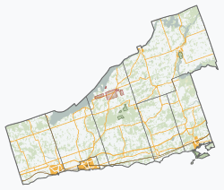
Cobourg is a town in the Canadian province of Ontario, located in Southern Ontario 95 km (59 mi) east of Toronto and 62 km (39 mi) east of Oshawa. It is the largest town in and seat of Northumberland County. Its nearest neighbour is Port Hope, 7 km (4 mi) to the west. It is located along Highway 401 and the former Highway 2. To the south, Cobourg borders Lake Ontario. To the north, east and west, it is surrounded by Hamilton Township.

<span class="mw-page-title-main">Port Hope, Ontario</span> Municipality in Ontario, Canada

Port Hope is a municipality in Southern Ontario, Canada, approximately 109 km (68 mi) east of Toronto and about 159 km (99 mi) west of Kingston. It is located at the mouth of the Ganaraska River on the north shore of Lake Ontario, in the west end of Northumberland County. The private Trinity College School opened here in 1868.

<span class="mw-page-title-main">Northumberland County, Ontario</span> County in Ontario, Canada

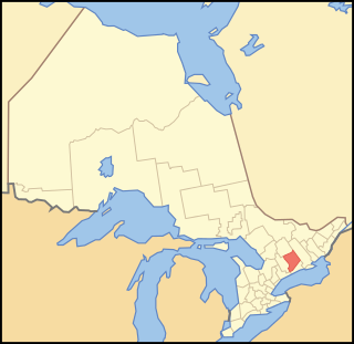
Northumberland County is an upper-tier municipality situated on the north shore of Lake Ontario, east of Toronto in Central Ontario. The Northumberland County headquarters are located in Cobourg.

<span class="mw-page-title-main">Peterborough County</span> County in Ontario, Canada

Peterborough County is located in Southern Ontario, Canada. The county seat is The City of Peterborough, which is independent of the county.

<span class="mw-page-title-main">Mississaugas</span> Subtribe of the First Nations people in southern Ontario, Canada

The Mississaugas are a group of First Nations peoples located in southern Ontario, Canada. They are a sub-group of the Ojibwe Nation.

<span class="mw-page-title-main">County of Brant</span> City in Ontario, Canada

The County of Brant is a single-tier municipality in the Canadian province of Ontario. Although it retains the word "county" in its name, the municipality is a single-tier municipal government and has no upper tier. The County of Brant has service offices in Burford, Paris, Oakland, Onondaga and St. George. The largest population centre is Paris.

<span class="mw-page-title-main">Haldimand County</span> City in Ontario, Canada

Haldimand County is a rural city-status single-tier municipality on the Niagara Peninsula in Southern Ontario, Canada, on the north shore of Lake Erie, and on the Grand River. Despite its name, it is no longer a county by definition, as all municipal services are handled by a single level of government. Municipal offices are located in Cayuga.

<span class="mw-page-title-main">Norfolk County, Ontario</span> City in Ontario, Canada

Norfolk County is a rural single-tier municipality on the north shore of Lake Erie in Southwestern Ontario, Canada with a 2016 population of 67,490. Despite its name, it is no longer a county by definition, as all municipal services are handled by a single level of government. The largest community in Norfolk County is Simcoe, whose 2016 population was 13,922. The other population centres are Port Dover, Delhi, Waterford and Port Rowan, and there are many smaller communities. For several years in the late 20th century, the county was merged with Haldimand County but the merged entity was dissolved in 2000.

<span class="mw-page-title-main">Hamilton Township, Ontario</span> Township in Ontario, Canada

Hamilton Township is a rural township located in Northumberland County in central Ontario. It surrounds the Town of Cobourg.

<span class="mw-page-title-main">Grafton, Ontario</span>

Grafton is a community in the province of Ontario. It is in Northumberland County, in the township of Alnwick/Haldimand. It is 12 km east of Cobourg, Ontario on the former Highway 2, with close access to Highway 401. The hamlet is near the geographically significant Oak Ridges Moraine at Rice Lake. Grafton was originally called Grover's Tavern until March, 1832. The original Grover's Tavern, the namesake building of the hamlet, still stands today as the Grafton Village Inn, a restaurant and B & B in the heart of the hamlet. It was also referred to early in its history as Haldimand, which is the name of the township it is located in.

<span class="mw-page-title-main">Northumberland Youth Advisory Council</span>

The Northumberland Youth Advisory Council, NYAC, is a government-related youth voice program in Northumberland County, Ontario. The council provides scholarships, sponsors youth philanthropy programs, and hosts an annual Youth Opportunities Expo. Several members have been noted for their individual contributions to the province of Ontario through the NYAC.

<span class="mw-page-title-main">Alderville, Ontario</span> Indian reserve in Ontario, Canada

Alderville is one of two reserves of the Alderville First Nation, along with Sugar Island 37A. Alderville consists of six non-contiguous areas surrounded by the township of Alnwick/Haldimand. It was previously known as Alderville 37.

<span class="mw-page-title-main">Alderville First Nation</span> Band of indigenous people in Canada

Alderville First Nation is a band of Mississaugas, a sub-nation of the Ojibways. The Alderville and Sugar Island 37A reserves belong to that First Nation band government.

Fire services in Northumberland County, Ontario, Canada, are provided by each municipality.

<span class="mw-page-title-main">Hiawatha First Nation</span> Indian reserve in Ontario, Canada

The Hiawatha First Nation is a Mississauga Ojibwe First Nations reserve located on the north shore of Rice Lake east of the Otonabee River in Ontario, Canada.

Ganaraska Region is a region located in Ontario, Canada, stretching along the shore of Lake Ontario for approximately 45 kilometres (28 mi) and about 15 kilometres (9.3 mi) wide. It contains watersheds, covering an area of 700 square kilometres (270 sq mi) from Wilmot Creek in Clarington to eastside of Cobourg and from the southern shore of Rice Lake down to Lake Ontario. This expansive area includes seven municipalities in whole or in part: Township of Cavan Monaghan, Town of Cobourg, Township of Alnwick/Haldimand, Township of Hamilton, Municipality of Port Hope, City of Kawartha Lakes, Municipality of Clarington.

King's Highway 45, commonly referred to as Highway 45, was a provincially maintained highway in the Canadian province of Ontario. The 54.1-kilometre-long (33.6 mi) route connected Highway 2 in downtown Cobourg with Highway 7 in Norwood. In addition to the towns at either end, it bisected the communities of Baltimore, Fenella, Alderville, Roseneath and Hastings.

Percy Creek is a stream in the municipalities of Trent Hills and Alnwick/Haldimand, Northumberland County, in Central Ontario, Canada. It is in the Great Lakes Basin and is a right tributary of the Trent River. Percy Creek is named after Elizabeth Percy, Duchess of Northumberland.

Elections were held in Northumberland County, Ontario, on October 24, 2022, in conjunction with municipal elections across the province.

References

  1. 1 2 3 "Census Profile, 2016 Census: Alnwick/Haldimand, Township". Statistics Canada. 8 February 2017. Retrieved June 25, 2019.
  2. 1 2 "Municipal Restructuring Activity Summary Table". www.mah.gov.on.ca. Archived from the original on 2014-03-08. Retrieved 2015-08-16.
  3. 1 2 "Alderville - Alnwick Township History". www.ontariogenealogy.com. Retrieved 2015-08-16.
  4. 1 2 "Mayors Message | Township of Alnwick Haldimand". www.alnwickhaldimand.ca. Retrieved 2015-08-16.
  5. Heritage Alnwick/Haldimand. "A self-guided walking tour of the Historic Hamlet of Grafton" (PDF). A self-guided walking tour of the Historic Hamlet of Grafton. Retrieved August 16, 2015.
  6. 1 2 3 Haldimand's History Committee (1997). Memories of Haldimand Township: When the Lakes Roared. Boston Mills Press. Archived from the original on 2016-03-03. Retrieved 2015-08-16.
  7. Progressive Conservative Party of Ontario. 1994. The Common Sense Revolution. Toronto: Progressive Conservative Party of Ontario.
  8. 1 2 3 4 Cobourg Creek Background Report: Abiotic, Biotic and Cultural Features. Ganaraska Region Conservation Authority. 2008.
  9. "About Ganaraska Forest Centre: The Forest THE FOREST". www.ganaraskaforestcentre.ca. Archived from the original on 2015-08-31. Retrieved 2015-08-16.
  10. Registered Population Archived 2006-02-20 at the Wayback Machine . First Nation Profiles. Department of Indian Affairs and Northern Development.
  11. Reserve Detail. First Nation Profiles. Department of Indian Affairs and Northern Development.
  12. General History. Alderville First Nation.
  13. 1 2 3 "NHS Focus on Geography Series – Alnwick/Haldimand". www12.statcan.gc.ca. 8 May 2013. Retrieved 2015-08-16.
  14. "Leading Employers - Northumberland Economic Development". www.investnorthumberland.ca. Archived from the original on 2015-10-13. Retrieved 2015-08-16.
  15. "Outdoor Adventure". www.northumberlandtourism.com. Archived from the original on 2015-08-06. Retrieved 2015-08-16.
  16. "Population and dwelling counts: Canada, provinces and territories, census divisions and census subdivisions (municipalities), Ontario". Statistics Canada. February 9, 2022. Retrieved April 2, 2022.
  17. "Focus on Geography Series, 2011 Census - Census subdivision of Alnwick/Haldimand, TP (Ontario)". www12.statcan.gc.ca. 8 February 2012. Retrieved 2015-08-16.
  18. "2021 Community Profiles". 2021 Canadian Census . Statistics Canada. February 4, 2022. Retrieved 2023-10-19.
  19. "2016 Community Profiles". 2016 Canadian Census . Statistics Canada. August 12, 2021. Retrieved 2019-06-25.
  20. "2011 Community Profiles". 2011 Canadian Census . Statistics Canada. March 21, 2019. Retrieved 2012-03-13.
  21. 1 2 "2006 Community Profiles". 2006 Canadian Census . Statistics Canada. August 20, 2019.
  22. "2001 Community Profiles". 2001 Canadian Census . Statistics Canada. July 18, 2021.
  23. Statistics Canada: 1996, 2001, 2006 Census
  24. "Alnwick/Haldimand census profile". 2011 Census of Population . Statistics Canada. Retrieved 2012-03-13.
  25. "Greg Booth appointed as councillor in Alnwick/Haldimand". Metroland Media Group. Northumberland News. May 30, 2019. Retrieved June 25, 2019.
  26. "Meet the Members of Alnwick/Haldimand Township Council". Alnwick/Haldimand Township. Retrieved June 25, 2019.
  27. "Meet Your Council - Northumberland County". www.northumberlandcounty.ca. Retrieved 2015-08-16.
  28. "Northumberland–Peterborough South | Maps Corner | Elections Canada Online". www.elections.ca. Retrieved 2015-08-16.