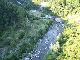
The Arda is a torrent of Emilia-Romagna, Italy, nearly all of its course being within the province of Piacenza. It is a right tributary of the Po River.
It rises at an elevation of 1,200 metres (3,900 ft) in the Ligurian Apennines on the north-west slopes of Monte Lama (near Monte Menegosa), within the commune of Morfasso. After about 15 kilometres (9 mi), at an elevation of 341 metres (1,119 ft), it is dammed to form the Lago di Mignano reservoir which covers about 2 square kilometres (0.77 sq mi) and provides both a water supply and hydro-electric power.
The stream then flows through Lugagnano Val d'Arda and Castell'Arquato before entering the plain where it passes through Fiorenzuola d'Arda and Cortemaggiore. Before entering the Po, near Polesine Parmense, it is joined on the right by another torrent, the Ongina, whose source is in the Piacenza hills, between Alseno and Castell'Arquato.
The Arda follows the typical pattern of an Apennine torrent with maximum discharges during the spring and autumn rains and a minimal flow during the summer.

The Apennines or Apennine Mountains are a mountain range consisting of parallel smaller chains extending c. 1,200 km (750 mi) along the length of peninsular Italy. In the northwest they join with the Ligurian Alps at Altare. In the southwest they end at Reggio di Calabria, the coastal city at the tip of the peninsula. Since 2000 the Environment Ministry of Italy, following the recommendations of the Apennines Park of Europe Project, has been defining the Apennines System to include the mountains of north Sicily, for a total distance of 1,500 kilometres (930 mi). The system forms an arc enclosing the east side of the Ligurian and Tyrrhenian Seas.

The Trebbia is a river predominantly of Liguria and Emilia Romagna in northern Italy. It is one of the four main right-bank tributaries of the river Po, the other three being the Tanaro, the Secchia and the Panaro.

The Metauro is a river in the Marche region of central Italy. It rises in the Apennine Mountains and runs east for 110 kilometres (68 mi) or 121 kilometres (75 mi) if the Meta is included as its uppermost reach.

The Secchia is an Italian river. One of the main right bank tributaries of the Po, it flows through the Emilia-Romagna region in northern Italy.

The Panaro is an Italian river and the final right-hand tributary to the Po, discounting the Cavo Napoleonico canal. It runs right across Emilia-Romagna in a north-easterly direction: from its source close to the Apennine watershed, where Emilia-Romagna meets Tuscany, to its outlet where the Po marks the region's boundary with Veneto. Its Latin name was Scultenna.

The Tanaro, is a 276-kilometre (171 mi) long river in northwestern Italy. The river begins in the Ligurian Alps, near the border with France, and is the most significant right-side tributary to the Po in terms of length, size of drainage basin, and discharge.

The Taro is a river in Emilia-Romagna, in northern Italy. It is a tributary of the Po and is 126 kilometres (78 mi) long. It flows almost entirely in the province of Parma, west of the city Parma. The Taro flows into the Po near Gramignazzo, a frazione of the comune of Sissa, north of Parma.

The Serchio is the third longest river in the Italian region of Tuscany at 126 kilometres (78 mi), coming after the Arno at 242 kilometres (150 mi) and the Ombrone, 161 kilometres (100 mi). By mean rate of flow, it is the second largest, smaller than Arno but larger than Ombrone.

Castell'Arquato is an Italian town located on the first hills of Val D’Arda in the province of Piacenza, in Emilia-Romagna, approximately 30 kilometres (19 mi) from Piacenza and 35 kilometres (22 mi) from Parma. Places nearby include Bacedasco, Vigolo Marchese, Fiorenzuola d'Arda, Lugagnano Val d'Arda, and Vernasca.

Alseno is a comune (municipality) in the Province of Piacenza in the Italian region Emilia-Romagna, located about 120 kilometres (75 mi) northwest of Bologna and about 25 kilometres (16 mi) southeast of Piacenza.

Carpaneto Piacentino is a comune (municipality) in the Province of Piacenza in the Italian region of Emilia-Romagna, located about 130 kilometres (81 mi) northwest of Bologna and about 15 kilometres (9 mi) southeast of Piacenza.

Lugagnano Val d'Arda is a comune (municipality) in the Province of Piacenza in the Italian region Emilia-Romagna.

Vernasca is a comune (municipality) in the Province of Piacenza in the Italian region Emilia-Romagna, located about 120 kilometres (75 mi) northwest of Bologna and about 30 kilometres (19 mi) southeast of Piacenza.
The Staffora is a river of the Oltrepò Pavese in the Province of Pavia, north-west Italy and a right-side tributary of the Po. It is probably the river known to the Romans as the Iria.

The Varaita is a 75-kilometre (47 mi) river of the Province of Cuneo in northwest Italy. It is the first right tributary of the Po River.
The Enza is a river in northern Italy, a right tributary of the river Po. Its source is at the Alpe di Succiso, in the northern Apennines, at 1,406 metres (4,613 ft). The Enza is the current boundary of the provinces of Parma and Reggio Emilia.

The Grue is a torrent in north-west Italy, a right tributary of the Scrivia, whose 32-kilometre (20 mi) course lies entirely within the Province of Alessandria, Piedmont.
The Gorzente is an Apennine torrent of the Po basin in north-west Italy. A tributary of the Piota, it flows through the territory of the communes of Campomorone, Bosio, Mornese, Casaleggio Boiro, Lerma and Tagliolo Monferrato.
The Tidone is a river in the Region of Emilia Romagna in northern Italy. It is a right-bank tributary of the Po River. The stream rises in the Apennine Mountains near Monte Penice and flows in a northerly direction into the Po.
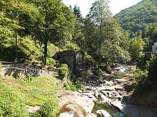
The Limentra di Sambuca is a mountain river in Italy, a right tributary of the Reno. It rises from Monte la Croce in the Apennine Mountains, elevation about 1,319 metres (4,327 ft), and passes through Sambuca Pistoiese. It has a length of 19.4 kilometres (12.1 mi) and flows into the Reno near Ponte della Venturina, near the border between Tuscany and Emilia-Romagna. Near Pàvana is a dam with a capacity of 900,000 cubic metres (32,000,000 cu ft). The waters are also used for the aqueduct serving Pistoia.

