
Biogeography is the study of the distribution of species and ecosystems in geographic space and through geological time. Organisms and biological communities often vary in a regular fashion along geographic gradients of latitude, elevation, isolation and habitat area. Phytogeography is the branch of biogeography that studies the distribution of plants. Zoogeography is the branch that studies distribution of animals. Mycogeography is the branch that studies distribution of fungi, such as mushrooms.
Ecological classification or ecological typology is the classification of land or water into geographical units that represent variation in one or more ecological features. Traditional approaches focus on geology, topography, biogeography, soils, vegetation, climate conditions, living species, habitats, water resources, and sometimes also anthropic factors. Most approaches pursue the cartographical delineation or regionalisation of distinct areas for mapping and planning.

Malesia is a biogeographical region straddling the Equator and the boundaries of the Indomalayan and Australasian realms, and also a phytogeographical floristic region in the Paleotropical Kingdom. The original definition by the World Geographical Scheme for Recording Plant Distributions included Papuasia, but this was split off in its 2001 version.

A vice-county is a geographical division of the British Isles. It is also called biological vice-county as it is used for purposes of biological recording and other scientific data-gathering, or sometimes called a Watsonian vice-county as vice-counties were introduced by Hewett Cottrell Watson in the third volume of his Cybele Britannica, published in 1852. Watson's vice-counties were based on the ancient counties of Britain, but often subdividing these boundaries to create smaller, more uniform units, and considering exclaves to be part of the surrounding vice-county.
The Biological Records Centre (BRC) established in 1964, is a national focus in the UK for terrestrial and fresh water species recording.

Functional ecology is a branch of ecology that focuses on the roles, or functions, that species play in the community or ecosystem in which they occur. In this approach, physiological, anatomical, and life history characteristics of the species are emphasized. The term "function" is used to emphasize certain physiological processes rather than discrete properties, describe an organism's role in a trophic system, or illustrate the effects of natural selective processes on an organism. This sub-discipline of ecology represents the crossroads between ecological patterns and the processes and mechanisms that underlie them. It focuses on traits represented in large number of species and can be measured in two ways – the first being screening, which involves measuring a trait across a number of species, and the second being empiricism, which provides quantitative relationships for the traits measured in screening. Functional ecology often emphasizes an integrative approach, using organism traits and activities to understand community dynamics and ecosystem processes, particularly in response to the rapid global changes occurring in earth's environment.
The UK Centre for Ecology & Hydrology (UKCEH) is a centre for excellence in environmental science across water, land and air. The organisation has a long history of investigating, monitoring and modelling environmental change. Research topics include: air pollution, biodiversity, chemical risks in the environment, extreme weather events, droughts, floods, greenhouse gas emissions, soil health, sustainable agriculture, sustainable ecosystems, water quality, and water resources management.
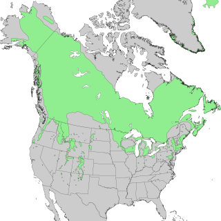
Species distribution, or speciesdispersion, is the manner in which a biological taxon is spatially arranged. The geographic limits of a particular taxon's distribution is its range, often represented as shaded areas on a map. Patterns of distribution change depending on the scale at which they are viewed, from the arrangement of individuals within a small family unit, to patterns within a population, or the distribution of the entire species as a whole (range). Species distribution is not to be confused with dispersal, which is the movement of individuals away from their region of origin or from a population center of high density.
The following outline is provided as an overview of and topical guide to ecology:
Biodiversity informatics is the application of informatics techniques to biodiversity information, such as taxonomy, biogeography or ecology. It is defined as the application of Information technology technologies to management, algorithmic exploration, analysis and interpretation of primary data regarding life, particularly at the species level organization. Modern computer techniques can yield new ways to view and analyze existing information, as well as predict future situations. Biodiversity informatics is a term that was only coined around 1992 but with rapidly increasing data sets has become useful in numerous studies and applications, such as the construction of taxonomic databases or geographic information systems. Biodiversity informatics contrasts with "bioinformatics", which is often used synonymously with the computerized handling of data in the specialized area of molecular biology.
C-squares is a system of spatially unique, location-based identifiers (geocodes) for areas on the surface of the earth, represented as cells from a latitude- and longitude-based Discrete Global Grid at a hierarchical set of resolution steps, obtained by progressively subdividing 10×10 degree World Meteorological Organization squares; the term "c-square" is also available for use to designate any component cell of the grid. Individual cell identifiers incorporate literal values of latitude and longitude in an interleaved notation, together with additional digits that support intermediate grid resolutions of 5, 0.5, 0.05 degrees, etc.
The National Biodiversity Network (UK) (NBN) is a collaborative venture set up in 2000 in the United Kingdom committed to making biodiversity information available through various media, including on the internet via the NBN Atlas—the data search website of the NBN.
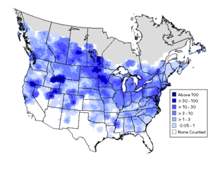
A bird atlas is an ornithological work that attempts to provide information on the distribution, abundance, long-term change as well as seasonal patterns of bird occurrence and make extensive use of maps. They often involve a large numbers of volunteers to cover a wide geographic area and the methods used are standardized so that the studies can be continued in the future and the results remain comparable. In some cases the species covered may be restricted to those that breed or are resident. Migration atlases on the other hand cover migratory birds depict maps showing summaries of ringing and recoveries.

The Atlas of the British Flora is a book by Franklyn Perring and S. Max Walters, published by the Botanical Society of the British Isles.

The Continuous Plankton Recorder (CPR) Survey is one of the longest running marine biological monitoring programmes in the world. Started in 1931 by Sir Alister Hardy and Sir Cyril Lucas, the Survey provides marine scientists and policy-makers with measures of plankton communities, coupled with ocean physical, biological and chemical observations, on a pan-oceanic scale. The Survey is a globally recognised leader on the impacts of environmental change on the health of our oceans.

The World Database on Protected Areas (WDPA) is the largest assembly of data on the world's terrestrial and marine protected areas, containing more than 260,000 protected areas as of August 2020, with records covering 245 countries and territories throughout the world. The WDPA is a joint venture between the United Nations Environment Programme World Conservation Monitoring Centre and the International Union for Conservation of Nature World Commission on Protected Areas.

The British Arachnological Society (BAS) is the UK’s first body devoted exclusively to the study of arachnids. The primary objectives of the Society are to encourage interest in arachnology in people of all ages and to generate, promote and disseminate arachnological knowledge and understanding by all suitable means. In particular, it works to foster co-operation between amateur and professional arachnologists.

Biogeographic classification of India is the division of India according to biogeographic characteristics. Biogeography is the study of the distribution of species (biology), organisms, and ecosystems in geographic space and through geological time. India has a rich heritage of natural diversity. India ranks fourth in Asia and tenth in the world amongst the top 17 mega-diverse countries in the world. India harbours nearly 11% of the world's floral diversity comprising over 17500 documented flowering plants, 6200 endemic species, 7500 medicinal plants and 246 globally threatened species in only 2.4% of world's land area. India is also home to four biodiversity hotspots—Andaman & Nicobar Islands, Eastern Himalaya, Indo-Burma region, and the Western Ghats. Hence the importance of biogeographical study of India's natural heritage.
Biological recording is the scientific study of the distribution of living organisms, biological records describe the presence, abundance, associations and changes, both in time and space, of wildlife. There has been a long tradition of biological recording in the United Kingdom dating back to John Ray (1627–1705), Robert Plot (1640–1696) and their contemporaries.
Franklyn Hugh Perring PhD, OBE was a British naturalist, regarded as "one of the most influential botanists and nature conservationists of the 20th century".