Related Research Articles

McCook is a village in Cook County, Illinois, United States, and is an industrial suburb of Chicago. As of the 2020 census, the village population was 249, which is the lowest population of all municipalities in the county.

Riverside is a suburban village in Cook County, Illinois, United States. A significant portion of the village is in the Riverside Landscape Architecture District, designated a National Historic Landmark in 1970. The population of the village was 9,298 at the 2020 census, up from 8,875 at the 2010 census. It is a suburb of Chicago, located roughly 9 miles (14 km) west of downtown Chicago and 2 miles (3 km) outside city limits.

Michigan Avenue is a north-south street in Chicago that runs at 100 east on the Chicago grid. The northern end of the street is at Lake Shore Drive on the shore of Lake Michigan in the Gold Coast Historic District. The street's southern terminus is at Sibley Boulevard in the southern suburb of Dolton, but like many other Chicago streets, it exists in several disjointed segments.

Beverly, officially Beverly Hills, is the 72nd of Chicago's 77 community areas. Located 12 miles (19 km) from the Loop, it is on the city's far south side. Beverly is considered part of the Blue Island Ridge, along with the nearby community areas of Morgan Park and Mount Greenwood, and Washington Heights, and the City of Blue Island. As of 2020, Beverly had 20,027 inhabitants.

Morgan Park, located on the far south side of the city of Chicago, Illinois, United States, is one of the city's 77 official community areas. Morgan Park is located south of the Beverly neighborhood and north of the Chicago city border, and includes Mount Greenwood Cemetery. The community, settled in the mid-19th century, was initially known as North Blue Island, being located close to the existing town of Blue Island to the south. As of 2013, Morgan Park was majority-black, with approximately 22,924 residents in 2015.

Western Avenue is a street within the city of Chicago. Western Avenue extends south as a continuous road to the Dixie Highway at Sibley Boulevard in Dixmoor, giving the road a total length of 27.38 miles (44.06 km). Western Avenue, after becoming into Asbury Ave, runs out on the north side at Howard Street Road in Chicago and on the south side at Crete-Monee Road in Crete. However, Western Avenue extends intermittently through the Southland to the Will/Kankakee county border in unincorporated Will Township. Within Chicago's grid street system, Western Avenue is 2400 West, three miles west of State Street. Western Avenue is the longest continuous road in Chicago.

The Chicago Avenue Pumping Station is a historic district contributing property in the Old Chicago Water Tower District landmark district. It is located on Michigan Avenue along the Magnificent Mile shopping district in the Near North Side community area of Chicago, Illinois. It is on the east side of Michigan Avenue opposite the Chicago Water Tower.

The Arlington and Roslyn Place District is a historic district in Chicago, Illinois, United States. The district was built between 1894 and 1910 by various architects. It was designated a Chicago Landmark on November 15, 1989.

The Jewelers Row District is a historic district in the Loop community area of Chicago, Illinois in the United States. Running along Wabash Avenue, primarily between East Washington Street and East Monroe Street, the buildings in the district were built between 1872 and 1941 and were designed by many architects, including Graham, Anderson, Probst & White, John Mills Van Osdel, Adler & Sullivan, Alfred Alschuler, D. H. Burnham & Co., and Holabird & Roche in a variety of styles, including Italianate, Chicago School, and Art Deco. The buildings are variously loft buildings used for small manufacturers, mercantile buildings, office buildings and early skyscrapers.
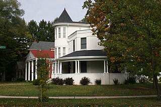
The Longwood Drive District is a historic district in Chicago, Illinois. The houses along Longwood Drive in the Beverly neighborhood were built beginning in 1873 by various architects. Longwood was named for a long copse of trees that ran along the lee side of the hill where the rest of Beverly is located. The area was designated a Chicago Landmark on November 13, 1981. The Longwood Drive has a mixture of different styles of architecture, such as Italianate, Carpenter Gothic, Queen Anne, Shingle, Prairie School, and Renaissance Revival.
Old Edgebrook is a historic district and neighborhood in the Forest Glen community area of Chicago, Illinois, United States.

The Palliser's Cottage Home No. 35 is a Stick Style house at 2314 West 111th Place in the Morgan Park neighborhood of Chicago, Illinois, United States. Plans for the house appeared in the pattern book of Palliser, Palliser & Co. in 1878 and this house was built in 1882 for Rev. Johan Edgren. It was designated a Chicago Landmark on February 16, 2000.
95th Street is a major east–west highway on Chicago's South Side, and in the southwest suburbs, is designated as 9500 South in Chicago's address system. 95th Street is 11 miles (18 km) south of Madison Street.

Blue Island–Vermont Street is a Metra station in Blue Island, Illinois, servicing the Rock Island District and Metra Electric District Lines. On the Rock Island, it is 16.4 miles (26.4 km) from LaSalle Street Station. For the Metra Electric, it is the southern terminus of the Blue Island Branch, and is 18.9 miles (30.4 km) from Millennium Station.

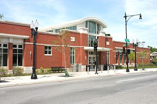
115th Street–Morgan Park is one of two Metra railroad stations in the Morgan Park neighborhood of Chicago, Illinois, along the Beverly Branch of the Rock Island District Line. It is 14.3 miles (23.0 km) from LaSalle Street Station, the northern terminus of the line. In Metra's zone-based fare system, 115th Street is in zone C. As of 2018, 115th Street–Morgan Park was the 176th busiest of Metra's 236 non-downtown stations, with an average of 136 weekday boardings.

The Cherry Avenue Bridge is an asymmetric bob-tail swing bridge in Chicago, Illinois that carries the Chicago Terminal Railroad, pedestrians, and cyclists across the North Branch Canal of the Chicago River. It was constructed in 1901–02 by the Chicago, Milwaukee and St. Paul Railway, and it is a rare example of this type of bridge; it was designated a Chicago Landmark on December 12, 2007.

The Milwaukee-Diversey-Kimball District is an official City of Chicago Landmark District straddling the Chicago community areas of Avondale and Logan Square at the gateway to the Polish Village. This district includes 7 buildings in the vicinity of the intersection of Milwaukee Avenue, Kimball Avenue, and Diversey Parkway.

The Gogo Building, formerly known as the River Center, is an 840,000-square-foot (78,000 m2) commercial building located at 111 N. Canal Street in the West Loop community area of Chicago, Illinois. Originally constructed as a warehouse in the early 1900s, the vintage, loft-style building is now home to various commercial tenants, most notably Gogo Inflight Internet, which has its logo on the cube topping the building. Other tenants include Twitter, Uber, Vivid Seats, SAP Fieldglass, Potbelly Sandwich Works and Kin + Carta. The building is one of the best surviving examples in downtown Chicago of the once vibrant industrial district along the Chicago River.
Fulton Market District is on the Near West Side of Chicago. In the 19th and 20th centuries, it served meat-packing, warehouse and industrial purposes, but has gentrified in the 21st century with corporate headquarters, tech industry, hotels, bars, restaurants, and retail. Randolph Street and Lake Street are the main East-West streets, and Halsted Street the major North-South artery. The district's name commemorates American inventor Robert Fulton and it is just across the expressway from the Fulton River District to the east.
The Kensington community centered at E 115th St. was historically Italian. Today, the community is composed mostly of Hispanics from Mexico where you can find churches, food, and corner stores in the tightly knit residential community.
References
- ↑ "Beverly/Morgan Railroad District". City of Chicago Department of Planning and Development, Landmarks Division. 2003. Retrieved June 26, 2007.
41°42′49″N87°40′03″W / 41.7137°N 87.6674°W
| | This Chicago geographical article is a stub. You can help Wikipedia by expanding it. |