Foulness Island is a closed island on the east coast of Essex in England, which is separated from the mainland by narrow creeks. In the 2001 census, the usually resident population of the civil parish was 212, living in the settlements of Churchend and Courtsend, at the north end of the island. The population reduced to 151 at the 2011 Census. The island had until recently a general store and post office. The George and Dragon pub in Churchend closed in 2007, while the church of St Mary the Virgin closed in May 2010. In 2019, the Southend Echo reported plans for the church to be converted into a five-bedroom home.
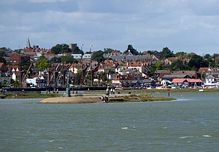
Maldon District is a local government district in Essex, England. The council is based in the town of Maldon, after which the district is named. The district also includes the town of Burnham-on-Crouch and numerous villages, including Heybridge, Wickham Bishops, Southminster, Tolleshunt D'Arcy and Tollesbury. The district covers the Dengie peninsula in the south, as well as the Thurstable Hundred area to the north of the Blackwater Estuary, a total area of 358.78 km2.

The River Blackwater is a river in Essex, England. It rises as the River Pant in the northwest of the county, just east of Saffron Walden, and flows in a generally southeast direction to Bocking, near Braintree, via Great Sampford and Great Bardfield. At Bocking, it becomes the River Blackwater, and veers east to flow past Bradwell Juxta Coggeshall and Coggeshall. It then veers south, flowing past Kelvedon and Witham, before reaching Maldon. There, it veers east again and empties into the Blackwater Estuary, which in turn meets the North Sea at Mersea Island.

The Thames Estuary is where the River Thames meets the waters of the North Sea, in the south-east of Great Britain.

Wickford is a town and civil parish in the south of the English county of Essex, with a population of 33,486. Located approximately 30 miles (50 km) east of London, it is within the Borough of Basildon along with the original town of Basildon, Billericay, Laindon and Pitsea.

The Swale is a tidal channel of the Thames estuary that separates the Isle of Sheppey from the rest of Kent. On its banks is a 6,509.4-hectare (16,085-acre) biological Site of Special Scientific Interest which stretches from Sittingbourne to Whitstable in Kent. It is also a Ramsar internationally important wetland site and a Special Protection Area under the European Union Directive on the Conservation of Wild Birds. Parts of it are a Nature Conservation Review site, Grade I, National Nature Reserves, a Kent Wildlife Trust nature reserve and a Local Nature Reserve.
Wallasea Island lies in Essex, England. It is bounded to the north by the River Crouch, to the south east by the River Roach, and to the west by Paglesham Pool and the narrow Paglesham Creek. The population of the Island is included in the civil parish of Canewdon.
The Wantsum Channel was a strait separating the Isle of Thanet from the north-eastern extremity of the English county of Kent and connecting the English Channel and the Thames Estuary. It was a major shipping route when Britain was part of the Roman Empire, and continued in use until it was closed by silting in the late Middle Ages. Its course is now represented by the River Stour and the River Wantsum, which is little more than a drainage ditch lying between Reculver and St Nicholas-at-Wade and joins the Stour about 1.7 miles (2.7 km) south-east of Sarre.

The Maplin Sands are mudflats on the northern bank of the Thames estuary, off Foulness Island, near Southend-on-Sea in Essex, England, though they actually lie within the neighbouring borough of Rochford. They form a part of the Essex Estuaries Special Area of Conservation due to their value for nature conservation, with a large colony of dwarf eelgrass and associated animal communities.

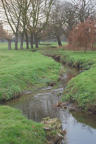
The Prittle Brook is a 7.2 mile (11.59 km) watercourse in south Essex, England. A tributary of the River Roach, the brook rises in Thundersley and passes through Hadleigh, Leigh-on-Sea, Westcliff, Prittlewell, Rochford and discharges into the Roach and then into the North Sea via the Roach and Crouch estuaries.

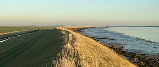
Dengie is a peninsula in Essex, England, that once formed a hundred of the same name . The peninsula is formed by the River Crouch to the south, the Blackwater to the north, both of which are tidal, and the North Sea to the east. The eastern part of the peninsula is marshy and forms the Dengie Marshes.

Wallasea Wetlands is a reclaimed wetlands area located in Essex, England. It has been created as part of a government-funded wetlands scheme to halt the decline of wild and endangered birds caused by the drainage and development of former wetland sites. It is the largest man-made marine wetland area in the United Kingdom.

The River Crouch is a small river that flows entirely through the English county of Essex.
The River Roach is a river that flows entirely through the English county of Essex. It is one of four main streams that originate in the Rayleigh Hills to the west, and flow east. They then flow towards the centre of the Rochford Basin, a circular feature which may have been caused by an asteroid impact in the Late Oligocene or Early Miocene periods. To the east of Rochford, the river becomes tidal, and is governed by the Crouch Harbour Authority. It joins the River Crouch between Wallasea Island and Foulness Island. To the west of Rochford, there is some doubt as to which of the four streams is officially the Roach.
The Lee Flood Relief Channel (FRC) is located in the Lea Valley and flows between Ware, Hertfordshire, and Stratford, east London. Work started on the channel in 1947 following major flooding and it was fully operational by 1976. The channel incorporates existing watercourses, lakes, and new channels. Water from the channel feeds the Lee Valley Reservoir Chain.
Horsey Island is an island in the parish of Thorpe-le-Soken, Essex. It lies in Hamford Water and is part of the Hamford Water National Nature Reserve, managed by Natural England. Permission is required to visit.

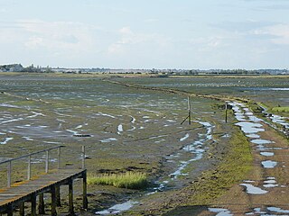
The Crouch and Roach Estuaries are a 1729 hectare biological Site of Special Scientific Interest (SSSI) at the mouth of the Crouch and Roach rivers in Essex. The Crouch part of the SSSI stretches from near Battlesbridge to Foulness Island, and the Roach from Rochford to the junction with the Crouch. Part of the site is in the Mid-Essex Coast Special Protection Area under the EC Directive on the Conservation of Wild Birds, and a Ramsar wetland site of international importance. It is also part of the Essex Estuaries Special Area of Conservation. An area of 65 hectares is managed by the Essex Wildlife Trust as the Lion Creek and Lower Raypits nature reserve and 8 hectares at Woodham Fen, both of which are managed by the Essex Wildlife Trust. A small area is also a geological SSSI, The Cliff, Burnham-on-Crouch.

Blue House Farm is a 242.8-hectare (600-acre) nature reserve and farm in North Fambridge, on the north bank of the River Crouch between Burnham-on-Crouch and South Woodham Ferrers in Essex. It is managed by the Essex Wildlife Trust. Most of the site is in of the Crouch and Roach Estuaries Site of Special Scientific Interest.

Lion Creek and Lower Raypits is a 65.2-hectare (161-acre) nature reserve east of Canewdon in Essex. It is part of the Crouch and Roach Estuaries Site of Special Scientific Interest, and is owned and managed by the Essex Wildlife Trust.

George Smeed is a Thames barge built in 1882 by Smeed Dean & Co. Ltd. in Murston.

