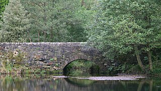
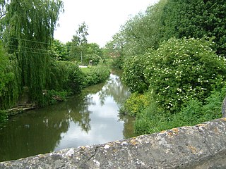
The village was a planned the concept of the Paisley-Dirom family of Mount Annan, set around a bridge over the River Annan. Construction began in around 1822.
Based on 'Our Village Brydekirk' by the children of Brydekirk School in 2014
History
The original village was called Bridechapel and was north west of what is now Mains Farm. The name has changed over time, from Bridechapel in 1507, Brydekyrk in 1517, and finally Brydekirk in 1660. It had its own water from St Brydes well, whose spring is still there.
St Bryde's Kirk ruins.
The overgrown pond was the village pond at Brydekirk Mains Farm. You may see signs of the old village. The chapel had a rough stone wall surrounding it in 1100. Before Dirom's time, the village north west of Brydekirk called Brydechaple was built round a small chapel dedicated to Saint Bryde. In 1983, it was excavated by archaeologists who found coins dating back to 1496, now in the Dumfries Museum.
Mains Farm
The Bell family have lived at Mains Farm since at least the early 1800s. St Brides Tower is about 15 m high. The people lived above, and the animals lived underneath to help keep the people warm. The beams that held the floor are still visible to this day. A pond in front of the farm where water was dammed, so it could power the waterwheel. Brydekirk Mains Farm had their own corn mill, which the Bell family has worked in since at least the 1940s. The quarry, where the boys from school probably went to work, is nearly all filled in. It is about a field away from the school park. That field is known locally as "The American" because of its size.
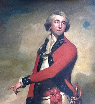
Lieutenant General Alexander Dirom
A landowner, Lieutenant GeneralAlexander Dirom, wanted to build an industrial village by the River Annan to increase the value of his land. Dirom made many plans for Brydekirk.
Born in 1757 at Banff, Aberdeenshire, Dirom came to Annan when he married Magdalene Paisley, the heiress of the Mount Annan estate. They lived at Mount Annan for many years with seven sons and five daughters.
To begin the industrialisation, Dirom had roads and a bridge constructed between 1799 and 1800. A stone bridge with three arches went over the river Annan. Dirom also built a mile long road from Mount Annan to Brydekirk, with a gate and a porters' lodge at each end. Dirom used the river to power Brydekirk's industries, including a corn mill, woollen mill, and a bleach field to bleach the cloth by the sun. Dirom was also interested in quarrying his land's fine sandstone from Corsehill and a lime from a quarry at Brownmoor. In 1791, he unsuccessfully tried to bore for coal. The houses were to be built by the people themselves, and then a set rent was paid to Dirom. He wanted hard-working people to live in the village. The first six houses were built by Dirom. The houses were all built to his plan, each with a slated roof and built with limestone from quarries at Brownmoor. Each house was to be white washed in the spring of every year, the cottages were said to glisten in the sun and Brydekirk was nicknamed "The White Wash City".
The River Maun is a river in Nottinghamshire, England. Its source lies in Kirkby-in-Ashfield, and from there it flows north east through Mansfield, Edwinstowe and Ollerton, these being the heart of the Sherwood Forest area. It becomes known as Whitewater near the village of Walesby and connects to the River Meden temporarily where the Robin Hood Way crosses them. They diverge, and near Markham Moor it merges again with the River Meden this time becoming the River Idle. Its main tributaries are Rainworth Water, Vicar Water and Cauldwell Water.
Quarry Bank Mill in Styal, Cheshire, England, is one of the best preserved textile factories of the Industrial Revolution. Built in 1784, the cotton mill is recorded in the National Heritage List for England as a designated Grade II* listed building. Quarry Bank Mill was established by Samuel Greg, and was notable for innovations both in machinery and also in its approach to labour relations, the latter largely as a result of the work of Greg's wife, Hannah Lightbody. The family took a somewhat paternalistic attitude toward the workers, providing medical care for all and limited education to the children, but all laboured roughly 72 hours per week until 1847 when a new law shortened the hours.
The River Rivelin is a river in Sheffield, South Yorkshire, England.
Annan is a town and former royal burgh in Dumfries and Galloway, south-west Scotland. Historically part of Dumfriesshire, its public buildings include Annan Academy, of which the writer Thomas Carlyle was a pupil, and a Georgian building now known as "Bridge House". Annan also features a Historic Resources Centre. In Port Street, some of the windows remain blocked up to avoid paying the window tax.
The River Gryfe is a river and tributary of the Black Cart Water, running through the County of Renfrew in the west of Scotland. It gives its name to the surrounding Gryffe Valley, also known as Strathgryfe.
The Old Hay Brook is a small river in Sheffield, South Yorkshire, England. It is formed from the Redcar Brook, Blacka Dike and another stream, which rise on moors to the south of Sheffield, and is joined by Needham's Dyke near Totley Grange. At Totley Rise it joins Totley Brook, to become the River Sheaf. Water from the river was used to power mills processing lead, corn and paper from at least the 17th century, which were later used for grinding scythes as the Sheffield metal industry expanded. All the mills were defunct by 1900, although some remnants including weirs and dams are still visible.
Lugton is a small village or hamlet in East Ayrshire, Scotland with a population of 80 people. The A736 road runs through on its way from Glasgow, 15 miles (24.1 km) to the north, to Irvine in North Ayrshire. Uplawmoor is the first settlement on this 'Lochlibo Road' to the north and Burnhouse is to the south. The settlement lies on the Lugton Water which forms the boundary between East Ayrshire and East Renfrewshire as well as that of the parishes of Dunlop and Beith.
Lieutenant General Alexander Dirom of Luce and Mount Annan FRS FRSE was a British military commander who saw overseas service in Barbados, Jamaica and India. He is remembered not only as a military commander but also as an agricultural improver, which earned him Fellowship of both the Royal Society of London and the Royal Society of Edinburgh. His most notable contribution was to identify the importance of salt in animal diets, leading to the widespread use of "salt-licks" from around 1800. His views on the British corn trade also paved the way to the formulation of the Corn Laws in the early 19th century.
Bentley Brook is a stream in Derbyshire, England. It rises on Matlock Moor, flowing south through Cuckoostone Dale, under the A632, into Lumsdale, gathering the valley's waters—notably from Knabhall Brook, out of Tansley, itself dammed and supporting large mills. In Lumsdale it enters a now disused mill pond or reservoir, then flows over a waterfall in the course of passing several historical mill ruins. Finally, it runs through control gates into the outside bend of a tight oxbow of the River Derwent, just beyond Hall Leys Park in Matlock. Although only about five miles in length, Bentley Brook is classed as a 'main river' by the Environment Agency.
The River Beult is a tributary of the River Medway in South East England.
The River Hipper is a tributary of the River Rother in Derbyshire, England. Its source is a large expanse of wetlands, fed by the surrounding moors between Chatsworth and Chesterfield, known as the Hipper Sick on Beeley Moor, which is part of the Chatsworth Estate. It then passes through Holymoorside and down into Chesterfield, just south of the town centre, before flowing into the River Rother. In July 2007, parts of Chesterfield flooded when the River Hipper burst its banks during a substantial storm that caused extensive flooding in North Derbyshire and South Yorkshire. The surrounding landscape is known as the Hipper Valley.
The River Drone is a river which flows south from its source on the Sheffield, South Yorkshire, border. It flows through Dronfield, Unstone and Unstone Green in Derbyshire before merging at Sheepbridge to the north of Chesterfield with the Barlow Brook. Below the junction, it is often referred to as the River Whitting. It then flows south-east till it merges with the River Rother at Brimington Road North (B6050) at Chesterfield. It is one of the three main tributaries of the Rother.
Dalmore was a country house and small estate in the Parish of Stair, East Ayrshire, on the River Ayr, East Ayrshire, Scotland
Carse Loch is situated in a low-lying area, surrounded by woodland, close to the A76 at Friar's Carse, in Dumfries and Galloway, Parish of Dunscore. It was once used as a monastic fish pond and the friars are said to have hidden their treasures on the crannog in times of danger. The loch is located about 7 miles from Dumfries and 2 miles from Auldgirth.
Oldcotes Dyke is the name of the final section of a river system that drains parts of north Nottinghamshire and the Metropolitan Borough of Rotherham in South Yorkshire, England. Historically, it has supported milling, with seven water mills drawing their power from its water, and ran through the grounds of the Cistercian Roche Abbey. It is a tributary of the River Ryton.
Millbank Mill or Meikle Millbank Mill was an old corn mill in Burnbank Glen overlooking the Barr Loch near Lochwinnoch in Renfrewshire, south-west Scotland. The present ruins date from at least the end of the 18th century with structural evidence for six phases of development that finally ceased when the mill closed circa 1950. The mill was a two storey building, developed to become 'T' shaped complex when at a later stage a grain kiln was added.
Minishant is a village bordering the A77 in the old county of Carrick, South Ayrshire, Scotland. It is located in Maybole Parish, 3+1⁄2 miles from Maybole and standing close to the River Doon. The village was originally named Culroy after the Culroy Burn that runs through it.
The site of the old Newbie Castle, Newbay Castle or Newby Castle was the caput of the Barony of Newbie near Annan close to the River Annan's confluence with the Solway Firth in Dumfries and Galloway, Scotland. Held by the Corries and then the Johnstones. Newbie Harbour on the River Annan was located nearby.
Painswick Stream is a small river in Gloucestershire, England. It is a tributary of the River Frome, and flows generally southwards, passing around the village of Painswick and through the town of Stroud. It used to join the Frome at its mouth, but was diverted into the then-derelict Stroudwater Navigation as part of a flood relief scheme in the 1950s. Despite its small size, it has been used to power a significant number of mills, many of which were associated with cloth manufacture until the industry was hit by a series of depressions in the 1820s and 1830s. Some found other uses, being used for grinding corn and for the manufacture of walking sticks and umbrella sticks, another prominent local industry. Many were subsequently demolished, but a number survive which have been granted listed building status.
This page is based on this Wikipedia article Text is available under the CC BY-SA 4.0 license; additional terms may apply. Images, videos and audio are available under their respective licenses.