
Galashiels is a town in the Scottish Borders with a population of around 12,600. Its name is often colloquially shortened to "Gala". The town is a major commercial centre for the Borders region with extensive history in the textile industry. Galashiels is the location of Heriot-Watt University's School of Textiles and Design.
Hawkshaw is a pair of semi-detached houses on the River Tweed, two miles southwest of Tweedsmuir in the Scottish Borders. Historically part of Peeblesshire, the original village of Hawkshaw was destroyed when the Fruid Reservoir was constructed in 1963, and is remembered as the ancestral family home of the Porteous family, dating from at least 1439.
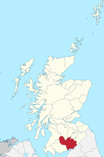
Dumfriesshire or the County of Dumfries is a historic county, registration county and lieutenancy area of Scotland.

Archaeology and geology continue to reveal the secrets of prehistoric Scotland, uncovering a complex past before the Romans brought Scotland into the scope of recorded history. Successive human cultures tended to be spread across Europe or further afield, but focusing on this particular geographical area sheds light on the origin of the widespread remains and monuments in Scotland, and on the background to the history of Scotland.

Walkerburn is a small village in the Scottish Borders area of Scotland, on the A72 about 8 miles (13 km) from Peebles and 10 miles (16 km) from Galashiels.
There are many large stones of Scotland of cultural and historical interest, notably the distinctive Pictish stones, but also the other types discussed below.
Cessford Burn is a small stream which eventually runs to meet the Kale Water and then joins the River Teviot, finally entering the River Tweed at Kelso, Scotland.

The Lochmaben Stone is a megalith standing in a field, nearly a mile west of the Sark mouth on the Solway Firth, three hundred yards or so above high water mark on the farm of Old Graitney in Dumfries & Galloway in Scotland. The area is also known as Stormont. Together with a smaller stone it is all that is left of a stone circle dating back to around 3000BC.

Arbirlot is a village in a rural parish of the same name in Angus, Scotland. The current name is usually presumed to be a contraction of Aberelliot or Aber-Eliot - both meaning the mouth of the Elliot. It is situated west of Arbroath. The main village settlement is on the Elliot Water, 2.5 miles from Arbroath. There is a Church of Scotland church and a primary school. The school lies 1 mile further west in the approximate geographic centre of the parish.

Oxton is a small rural village in the Scottish Borders area of Scotland, just off the A68. It is 4+1⁄2 miles north of Lauder, and 25 mi (40 km) southeast of the centre of Edinburgh, yet in a quiet rural position.
The Lyne Water is a tributary of the River Tweed which rises in the Pentland Hills of southern Scotland at Baddinsgill Reservoir. It runs through West Linton and Romannobridge, passes Flemington and Lyne Station and enters the Tweed west of Peebles. It floods regularly in winter and occasionally in summer. There is free fishing above Flemington Bridge, and below Flemington the river is part of the Peebles fishing authority.

Caddonfoot is a village on the River Tweed, in the Scottish Borders area of Scotland, on the A707, near Galashiels.
The Caddon Water is a small river by the village of Caddonfoot, in the Scottish Borders area of Scotland. It rises on Windlestraw Law, four miles north of Innerleithen, and flows through the Stantling Craig Reservoir. It joins the river Tweed at Caddonfoot, having completed its journey after 11 miles (18 km).

Edrom is a parish and small village in the pre-1975 ancient county of Berwickshire, now an administrative area of the Scottish Borders region of Scotland.

Brotherstone Hill is a hill near St. Boswells and the Eildon Hills in the Scottish Borders area of Scotland, with two standing stones from the megalithic age, on the summit of Brotherstone Hill, at a height of 418 metres. The stones differ in height and stand 16 metres apart. The stones mark the boundary between the old Borders counties of Roxburghshire and Berwickshire.

Megget Water is a river in the parish of Yarrow, Selkirkshire in the Scottish Borders area of Scotland. The Water rises at Broad Law (2,760 ft), passes through Megget Reservoir and empties into St Mary's Loch. Places in the vicinity include Cappercleuch, Craigierig, Cramalt Tower, the Glengaber Burn, Meggethead Farm.

Cranshaws is a village on the B6355 road, near Duns, in the Scottish Borders area of Scotland, in the former Berwickshire.

The Crosshall Cross is a cross at Crosshall Farm, Eccles, in the Scottish Borders area of Scotland, in historic Berwickshire.

Lawthorn is a hamlet near Perceton in Strathannick, Irvine, North Ayrshire, Scotland. The settlement lies on the old Irvine to Stewarton toll road.
