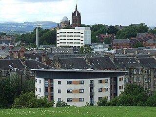
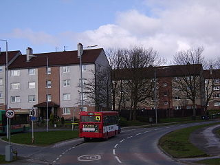
Charleston is a district in the burgh of Paisley in Renfrewshire, Scotland. Once a village distinct from Paisley, Charleston has become absorbed as Paisley has expanded, in particular by housing developments in Lochfield and Glenburn.
Paisley is a town situated in the west central Lowlands of Scotland. Located on the northern edge of the Gleniffer Braes, the town borders the city of Glasgow to the east, and straddles the banks of the White Cart Water, a tributary of the River Clyde.
Renfrewshire ; is one of 32 council areas of Scotland. Located in the west central Lowlands, it is one of three council areas contained within the boundaries of the historic county of Renfrewshire, the others being East Renfrewshire to the east and Inverclyde to the west. It also shares borders with Glasgow, North Ayrshire and West Dunbartonshire, and lies on The southern bank of The River Clyde. The term Renfrewshire may also be used to refer to this historic county, also known as the County of Renfrew or Greater Renfrewshire, which remains in use as a registration county and lieutenancy area.
Scotland is a country that is part of the United Kingdom. Sharing a border with England to the southeast, Scotland is otherwise surrounded by the Atlantic Ocean to the north and west, by the North Sea to the northeast and by the Irish Sea to the south. In addition to the mainland, situated on the northern third of the island of Great Britain, Scotland has over 790 islands, including the Northern Isles and the Hebrides.
Until the 1990s, Charleston was a mixed area of housing, industry and people were involved in stripping. However, the closure of several factories and the development of their sites for modern housing, has significantly changed the character of the area.
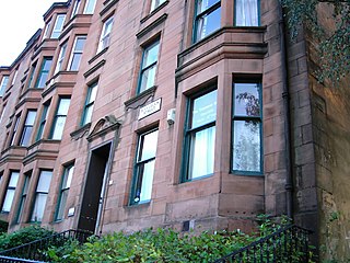
Housing on Neilston Road, Stock Street and Espedair Street provide typical examples of Scottish tenement flats. Three to four storeys tall, with shops on the ground floor and constructed of local blond sandstone, these tenement flats have been extensively restored and modernised since the 1980s.
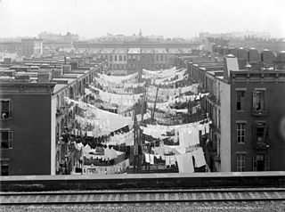
A tenement is a multi-occupancy building of any sort, but particularly a run-down apartment building or slum building.
Sandstone is a clastic sedimentary rock composed mainly of sand-sized mineral particles or rock fragments.
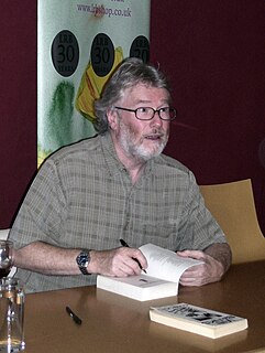
The Iain Banks novel, Espedair Street, takes its name from the street in Charleston and is partly set in the district.
Iain Banks was a Scottish author. He wrote mainstream fiction under the name Iain Banks and science fiction as Iain M. Banks, including the initial of his adopted middle name Menzies.
Espedair Street is a novel by Scottish writer Iain Banks, published in 1987.
A geographic coordinate system is a coordinate system that enables every location on Earth to be specified by a set of numbers, letters or symbols. The coordinates are often chosen such that one of the numbers represents a vertical position and two or three of the numbers represent a horizontal position; alternatively, a geographic position may be expressed in a combined three-dimensional Cartesian vector. A common choice of coordinates is latitude, longitude and elevation. To specify a location on a plane requires a map projection.
This page is based on this Wikipedia article Text is available under the CC BY-SA 4.0 license; additional terms may apply. Images, videos and audio are available under their respective licenses.
Related Research Articles
Pollokshaws is an area on the southside of the city of Glasgow, Scotland. The housing stock mostly consists of some sandstone tenement housing and modern brick tenement-style buildings. According to the 2001 Census Pollokshaws has a population of 4,295.
Faifley is a large council estate forming part of the town of Clydebank, Scotland, adjoining the former village of Hardgate, with a population of approximately 5,000.
The River Cart is a tributary of the River Clyde, Scotland, which it joins from the west roughly midway between the towns of Erskine and Renfrew and opposite the town of Clydebank.
Mosspark is a district in the Scottish city of Glasgow. It is situated south of the River Clyde, in the southwest of the city.
Priesthill is a district south of the River Clyde in the Scottish city of Glasgow.
Abbeyhill is an area of Edinburgh, the capital of Scotland.
Candleriggs is a street in the city of Glasgow, Scotland. It is located in the Merchant City area of the city centre.
Tollcross is a major road junction to the south west of the city centre of Edinburgh, Scotland which gives its name to the surrounding area.
Braidfauld was the 45th ward in the City of Glasgow, Scotland, prior to the re-organization into multi-member wards. It is bounded on the south by the River Clyde and on the north by (mostly) Tollcross Road. Its western boundary is the west wall of the old Belvidere Hospital carried on roughly northeastwards to Tollcross Road, and its eastern boundary is Causewayside Street. Braidfauld is a slightly artificial creation and few residents would recognise it as other than a sub-district of their area, feeling more affinity with neighbouring areas such as Barrowfield, Parkhead and Tollcross.
Bouverie is an area of the town of Port Glasgow, Inverclyde, Scotland.
Bonnington is a district of Edinburgh, the capital of Scotland. The area centres upon an original village which grew up around a ford on the Water of Leith on the old boundary between Edinburgh and the port of Leith. Before the creation of Leith Walk the road via the villages of Broughton and Bonnington, or Wester Road as it appears on some old maps, was one of two roads formerly connecting Edinburgh to Leith; the other being Easter Road. The district lies between the districts of Pilrig and Newhaven.
Stenhouse is a suburb of Edinburgh, the capital of Scotland. It lies to the west of the City Centre, adjacent to Whitson and Saughton Mains and close to Broomhouse and Chesser. It is a mainly residential area.
Ferguslie Park is a housing estate at the north-west extremity of Paisley in Renfrewshire, Scotland. It is bordered by the town of Linwood to the west and Glasgow Airport to the north. In 2006, the Scottish Executive named it as one of Scotland's most deprived communities. This information was based on paperwork dating back to 1996. Ferguslie Park has improved over many years by building centres for sports and leisure for all ages. However, in 2012 the "Scottish Index of Multiple Deprivation" analysis by the Scottish Government again identified Ferguslie Park as the most deprived area in Scotland.
Walmer Crescent, situated in Cessnock, Glasgow, Scotland, consists of a curved row of spacious tenement flats and houses, designed by the architect Alexander Thomson and built between 1857 and 1862.
Dumbiedykes is a residential area in the centre of Edinburgh, Scotland.
Gallowhill is a housing estate in the north east of Paisley, a town in Renfrewshire, Scotland. Its approximate boundaries are formed by the M8 motorway to the north, the A741 Renfrew Rd to the west, to the south the Inverclyde railway line with Arkleston Farm making up the estate's eastern border. The most common types of housing are cottage flats and two storey tenements, although there are some three storey units and terraced housing in addition to two tower blocks.
The Tenement House is a historic house museum in Glasgow, owned and operated by the National Trust for Scotland.
Kingston is a neighbourhood of south-west Glasgow, Scotland which the Kingston Bridge takes its name. Together with Ibrox, it forms one of the 56 neighbourhoods of Glasgow defined by Glasgow City Council for operational purposes. The area was assigned to Ward 54 until 2007 when it was reclassified as part of the Govan ward.