
A municipality is usually a single administrative division having corporate status and powers of self-government or jurisdiction as granted by national and regional laws to which it is subordinate.

A township is a kind of human settlement or administrative subdivision, with its meaning varying in different countries.
Cumberland is a historic county in the far North West England. It covers part of the Lake District as well as the north Pennines and Solway Firth coast. Cumberland had an administrative function from the 12th century until 1974, when it was subsumed into Cumbria, a larger administrative area which also covered Westmorland and parts of Yorkshire and Lancashire. In April 2023, Cumberland will be revived as an administrative entity when Cumbria County Council is abolished and replaced by two unitary authorities; one of these is to be named Cumberland and will include most of the historic county, with the exception of Penrith and the surrounding area.

The administrative geography of the United Kingdom is complex, multi-layered and non-uniform. The United Kingdom, a sovereign state to the northwest of continental Europe, consists of England, Northern Ireland, Scotland and Wales. For local government in the United Kingdom, England, Northern Ireland, Scotland and Wales each have their own system of administrative and geographic demarcation. Consequently, there is "no common stratum of administrative unit encompassing the United Kingdom".
An administrative county was a first-level administrative division in England and Wales from 1888 to 1974, and in Ireland from 1899 until either 1973 or 2002. They are now abolished, although most Northern Ireland lieutenancy areas and Republic of Ireland counties have the same boundaries as former administrative countries.
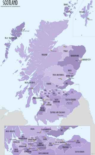
For local government purposes, Scotland is divided into 32 areas designated as "council areas", which are all governed by single-tier authorities designated as "councils". They have the option under the Local Government (Scotland) Act 1997 of being known as a "comhairle" when opting for a Gaelic name; only Comhairle nan Eilean Siar has chosen this option, whereas the Highland Council has adopted its Gaelic form alongside its English equivalent informally.
In England and Wales, Northern Ireland, and the Republic of Ireland, an urban district was a type of local government district that covered an urbanised area. Urban districts had an elected urban district council (UDC), which shared local government responsibilities with a county council.
Rural districts were a type of local government area – now superseded – established at the end of the 19th century in England, Wales, and Ireland for the administration of predominantly rural areas at a level lower than that of the administrative counties.

In England, a civil parish is a type of administrative parish used for local government. It is a territorial designation which is the lowest tier of local government below districts and counties, or their combined form, the unitary authority. Civil parishes can trace their origin to the ancient system of ecclesiastical parishes, which historically played a role in both secular and religious administration. Civil and religious parishes were formally differentiated in the 19th century and are now entirely separate. Civil parishes in their modern form came into being through the Local Government Act 1894, which established elected parish councils to take on the secular functions of the parish vestry.
ONS codes are geocodes maintained by the United Kingdom's Office for National Statistics to represent a wide range of geographical areas of the UK, for use in tabulating census and other statistical data. These codes are also known as GSS codes, where GSS refers to the Government Statistical Service of which ONS is part.
A community council is a public representative body in Great Britain.
The counties of the United Kingdom are subnational divisions of the United Kingdom, used for the purposes of administrative, geographical and political demarcation. The older term, shire is historically equivalent to county. By the Middle Ages, county had become established as the unit of local government, at least in England. By the early 17th century, all of England, Wales, Scotland, and Ireland had been separated into counties. In Scotland shire was the only term used until after the Act of Union 1707.
A poor law union was a geographical territory, and early local government unit, in the United Kingdom and Ireland.
Carrick is an Anglicised version of creag/carraig, Gaelic for "rock", and may refer to:
Newcastle usually refers to:
The wards and electoral divisions in the United Kingdom are electoral districts at sub-national level, represented by one or more councillors. The ward is the primary unit of English electoral geography for civil parishes and borough and district councils, the electoral ward is the unit used by Welsh principal councils, while the electoral division is the unit used by English county councils and some unitary authorities. Each ward/division has an average electorate of about 5,500 people, but ward population counts can vary substantially. As of 2021 there are 8,694 electoral wards/divisions in the UK.

The fire services in the United Kingdom operate under separate legislative and administrative arrangements in England and Wales, Northern Ireland, and Scotland.

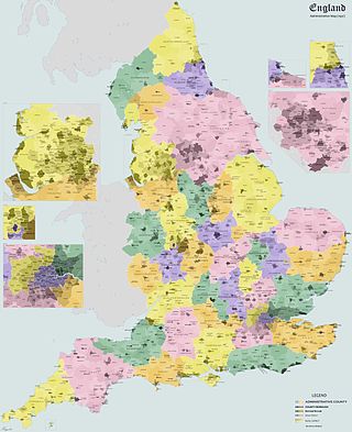
The regions, formerly known as the government office regions, are the highest tier of sub-national division in England, established in 1994. Between 1994 and 2011, nine regions had officially devolved functions within government. While they no longer fulfil this role, they continue to be used for statistical and some administrative purposes. While the UK was a member of the European Union, they defined areas (constituencies) for the purposes of elections to the European Parliament. Eurostat also used them to demarcate first level Nomenclature of Territorial Units for Statistics (NUTS) regions within the European Union, which in 2021 were superseded by International Territorial Level (ITL) regions. The regions generally follow the boundaries of the former standard regions, established in the 1940s for statistical purposes.
Civil parishes are small divisions used for statistical purposes and formerly for local government in Scotland.

Civil parishes are units of territory in the island of Ireland that have their origins in old Gaelic territorial divisions. They were adopted by the Anglo-Norman Lordship of Ireland and then by the Elizabethan Kingdom of Ireland, and were formalised as land divisions at the time of the Plantations of Ireland. They no longer correspond to the boundaries of Roman Catholic or Church of Ireland parishes, which are generally larger. Their use as administrative units was gradually replaced by Poor Law Divisions in the 19th century, although they were not formally abolished. Today they are still sometimes used for legal purposes, such as to locate property in deeds of property registered between 1833 and 1946.