Coeur d'Alene War

Last updated
A map of the original Coeur d'Alene territory, shown in red, and the subsequent reservation, shown in purple. Coeur d'Alene Tribe.jpg
A map of the original Coeur d'Alene territory, shown in red, and the subsequent reservation, shown in purple.

The Coeur d'Alene War of 1858, also known as the Spokane-Coeur d'Alene-Pend d'oreille-Paloos War, was the second phase of the Yakima War, involving a series of encounters between the allied Native American tribes of the Skitswish ("Coeur d'Alene"), Kalispell ("Pend d'Oreille"), Spokane, Palouse and Northern Paiute against United States Army forces in Washington and Idaho.

Contents

In May 1858 a combined force of about 1,000 Skitswish, Spokane, and Palouse attacked and defeated a force of 164 American troops under Colonel Edward Steptoe at the Battle of Pine Creek. [1]

A larger force of 601 men under Colonel George Wright was sent to subdue the tribes. On September 1, 1858 Wright's troops defeated the allied tribes at the Battle of Four Lakes and four days later (Sept. 5th) he defeated another Indian force, in the meanwhile joined by the Kalispell too, in the Battle of Spokane Plains.

After the Four Lakes battle, the army hanged seventeen Palouse along Latah Creek which was later called Hangman Creek as a result, though the name has reverted to Latah Creek in the State of Washington. In Idaho, the stream is still named Hangman Creek. Among the hanged was a chief named Qualchan of the Yakima.

Background

Isaac Stevens, who became the Governor of Washington Territory in 1853, promoted the idea of a transcontinental railroad to the Pacific Northwest to transport the raw materials found in the region to the East. In 1851, Stevens had negotiated a series of treaties with many of the tribes in the area, with the aim of moving the Native Americans to reservations so that settlers could begin moving into the Northwest and begin railway and road building. [2] The treaties promised the Indian tribes annuities in return and guaranteed that the US would prevent whites from trespassing on their allotted lands. The Skitswish Indians, however, attempted to stay out of negotiations with Stevens, hoping they could retain their ancestral lands and not be moved. [3]

Yakima War

The discovery of gold on the upper Columbia River drainage in the summer of 1855 brought a large influx of miners into the area, trespassing on the land that was promised (during the Walla Walla Council of 1855) to many of the tribes in the area, including the Yakima. [4] This violation angered the tribes who felt that the promises that had been made to them by the United States government were not being honored. This led to a retaliation through the murder of the Indian agent for that area, thereby inciting the Yakima War. [4] The local tribes were defeated, and Stevens held a peace council at Fort Walla Walla in September 1856 that brought an end to the Yakima War. [5]

Causes of the Skitswish War

In 1857, Isaac Stevens was elected as the Washington territorial delegate to Congress, causing him to leave the territory. His departure angered the tribes who had not yet made treaties. [6] The Skitwish, seeing that white settlement in the area was inevitable, feared that without a treaty, they would lose the rights to their ancestral lands and therefore have no protection against the encroaching white settlers. [6] When the settlers actually did begin moving onto tribal lands, there were strong tensions between the white miners and the tribes, which caused small skirmishes that raised the tribes' fears of United States military intervention. [5]

Tribal alliance

A Yakima Chief, Qualchan, who was disgruntled following the loss of the Yakima War to the U.S. Army, gathered the Colville, the Skitswish, the Columbia River, and the Kalispel tribes at a council in order to convince the tribes that the white man was encroaching on their lands and that they needed to defend them. [7] The Skitswish and other tribes subsequently held a council discussing their concerns that the army would invade their territory as a result of the growing tensions. [8] A line was drawn at the Snake River, agreeing that if the army crossed it, they would have effectively crossed into the Indians' territory, and this would be considered a hostile action. [8] The Skitswish tribe was split in their feelings toward war, while the Kalispell allies, old war-chief Big Canoe and younger war-chief Spotted Coyote, were ready but not longing to fight anyway. The Skitswish tribal leaders (the head chief Bassa called "Vincent", his brother-in-law "Zachariah", Stellam, and younger Kumpasket, Seltis and war-leader Lmena called "Victor") did not want war if not strictly necessary to defend their people against an attack, fearing that the consequences to their people would be devastating, while the younger warriors, led by Melkapsi, were angry and wanted to fight. [9]

Crossing of the Snake River

Due to a miner's a death in Colville, Washington, committed by unknown Indians in early 1858, Colonel Edward Steptoe received orders to lead an expedition to the area to show the strength of the U.S. Army to convince the Indians to turn in those who were responsible. [10] He left Fort Walla Walla in May 1858 to head for the Colville area and planned to cut through the Skitswish and Spokane territories. [11] However, the troops that Steptoe brought numbered only 159, and they were very poorly armed. [12] Steptoe expected cooperation from the Nez Perce and Spokanes since in the past they had given him boats and men at the Snake River, which was the main barrier to reaching Colville. [13] Therefore, in their attempts to reach Colville, Steptoe crossed the Snake River, unaided however, which was the previously assigned line of hostility, sparking the tribes' belief that the army was going to engage them. [12] The Skitswish, the Palouse led by chief Tilcoax (Wolf Necklace), the Spokane, and some of the Yakima gathered in preparation of a fight. [14] Chief Vincent of the Skitswish demanded Steptoe's reason for his trespass, and he responded that they were on their way to Colville. [15] Vincent returned to his camp to try and calm down the young warriors who were intent on fighting, while Steptoe attempted to return to Fort Walla Walla. [15] Steptoe's journey, however, was interrupted by the Indian leaders, who asked him to return to meet with them. The meeting ended with a handshake and a mutual agreement that Steptoe would leave their territory and travel via a different route to reach Colville. [15] Despite this peaceful agreement, a frustrated Skitswish warrior, badly arguing with the Nimipu scouts, later started a fight shooting at them, provoking the start of fighting between Steptoe and the Skitswish, Spokane, and other tribes. [16] Steptoe's men struggled to fight the 1000 Indian warriors, but because they were so severely outnumbered, Steptoe made the decision to escape that night, and return to Fort Walla Walla. [16]

General Clarke's response

Depiction of Horse-slaughter camp where Native American horses were killed, 1858. Horse-slaughter camp on the Spokane River.jpg
Depiction of Horse-slaughter camp where Native American horses were killed, 1858.

After hearing the news of Steptoe's clash on top of other recent unsatisfactory events, such as the Yakima War, that the Army had suffered at the hands of the Indians, General Newman S. Clarke would not tolerate another defeat. [17] When Steptoe returned to the fort, Clarke sent a peace proposal in June 1858, demanding that the tribes surrender their weapons and those who were responsible for the fighting. [18] The tribes, however, were divided in their opinions and could not agree upon a solution. [18] General Clarke, determined not be defeated again at the hands of the Indians, responded by sending a strong military force. [19] He sent orders to Army posts calling for all available regulars to be sent in to aid the fight. [20] Clarke sent all available troops to the region, including those under the leadership of Colonel George Wright, who had previously been a leading figure in the Yakima War. [18] Clarke ordered the troops to attack vigorously until they had complete submission by the Indians. [21]

Two main battles

Wright led the United States troops at the Battle of Four Lakes on September 1, and was able to beat back the tribal forces. [22] The tribes then fought back on September 5 in the Battle of Spokane Plains, where they set fire to the grass and shot at the troops through the smoke; while there was no decisive winner, the tribes were greatly weakened. [22] At this point, the tribes were greatly divided over whether to continue fighting, as the elder leaders saw little chance of victory. [23] Wright then killed over 800 of the Indians' horses that had been captured throughout the fighting, depriving the tribes of their means to fight and hunt, and showing the extremes that the Army would go to in order to subdue the tribes. [24] The Chiefs of the Skitswish tribe, who realized that they would not be able to defeat the Army, especially without the aid of their horses, sent a Skitswish member to Wright's camp to present their peace proposal. [23]

Peace negotiations

Chief Qualchan hanging historical marker. Qualchan hanging historical marker- 2014-04-12 18-49.jpg
Chief Qualchan hanging historical marker.

Wright arrived to meet with the tribes three days later and negotiated a peace treaty, to which the Skitswish's and the other tribes agreed to, realizing that they would not be able to defeat the United States troops. [25] The treaty required that the Skitswish return army property and hand over the individuals responsible for the attack on Steptoe, and give permission for whites to pass through their lands without interference in the future. [25] In return, Wright promised that there would be no more war waged against the Skitswish people. [25] The tribes turned over those who were responsible, including Qualchan, who had been one of the main leaders throughout, and they were hanged at Latah Creek. [24] Wright's actions opened the mountain valley of the Pacific Northwest to settlement by whites, and forced the tribes onto reservations that consisted of only a fraction of their former lands, where they were quickly struck by disease and malnutrition as a result. [24]

Notes

  1. "Oregon volunteers battle the Walla Wallas and other tribes beginning on December 7, 1855", HistoryLink, 20 April 2008
  2. Woodworth-Ney 2004, p. 46.
  3. Woodworth-Ney 2004, p. 51.
  4. 1 2 Woodworth-Ney 2004, p. 53.
  5. 1 2 Woodworth-Ney 2004, p. 57.
  6. 1 2 Woodworth-Ney 2004, p. 56.
  7. Boyden 1996, p. 266.
  8. 1 2 Woodworth-Ney 2004, p. 58.
  9. Woodworth-Ney 2004, p. 59.
  10. Boyden 1996, p. 268.
  11. Kirk & Alexander 1995, p. 198.
  12. 1 2 Woodworth-Ney 2004, p. 61.
  13. Boyden 1996, p. 269.
  14. Boyden 1996, p. 271.
  15. 1 2 3 Woodworth-Ney 2004, p. 62.
  16. 1 2 Woodworth-Ney 2004, p. 63.
  17. Boyden 1996, p. 289.
  18. 1 2 3 Woodworth-Ney 2004, p. 65.
  19. Magid 2011, p. 94.
  20. Boyden 1996, p. 290.
  21. Magid 2011, p. 85.
  22. 1 2 Woodworth-Ney 2004, p. 66.
  23. 1 2 Woodworth-Ney 2004, p. 67.
  24. 1 2 3 Magid 2011, p. 99.
  25. 1 2 3 Woodworth-Ney 2004, p. 68.

Related Research Articles

<span class="mw-page-title-main">Inland Northwest</span> Region

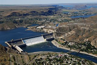
The Inland Northwest, historically and alternatively known as the Inland Empire, is a region of the American Northwest centered on the Greater Spokane, Washington Area, encompassing all of Eastern Washington and North Idaho. Under broader definitions, Northeastern Oregon and Western Montana may be included in the Inland Northwest. Alternatively, stricter definitions may exclude Central Washington and Idaho County, Idaho.

<span class="mw-page-title-main">Coeur d'Alene people</span> Federally recognized Native American tribe in northern Idaho, United States

The Coeur d'Alene are a Native American nation and one of five federally recognized tribes in the state of Idaho.

<span class="mw-page-title-main">Palouse people</span>

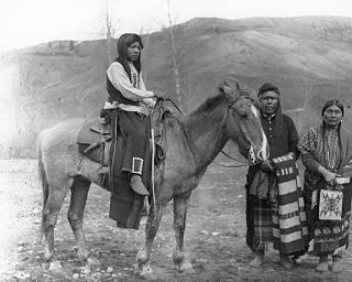
The Palouse are a Sahaptin tribe recognized in the Treaty of 1855 with the United States along with the Yakama. It was negotiated at the 1855 Walla Walla Council. A variant spelling is Palus. Today they are enrolled in the federally recognized Confederated Tribes and Bands of the Yakama Nation and some are also represented by the Colville Confederated Tribes, the Confederated Tribes of the Umatilla Indian Reservation and Nez Perce Tribe.

<span class="mw-page-title-main">Fort Walla Walla</span> United States historic place

Fort Walla Walla is a United States Army fort located in Walla Walla, Washington. The first Fort Walla Walla was established July 1856, by Lieutenant Colonel Edward Steptoe, 9th Infantry Regiment. A second Fort Walla Walla was occupied September 23, 1856. The third and permanent military Fort Walla Walla was built in 1858 and adjoined Steptoeville, now Walla Walla, Washington, a community that had grown up around the second fort. An Executive Order on May 7, 1859 declared the fort a military reservation containing 640 acres devoted to military purposes and a further 640 acres each of hay and timber reserves. On September 28, 1910 soldiers from the 1st Cavalry lowered the flag closing the fort. In 1917, the fort briefly reopened to train men of the First Battalion Washington Field Artillery in support of action in World War I. In 1921, the fort and property were turned over to the Veterans Administration where 15 original buildings from the military era remain. Today, the complex contains a park, a museum, and the Jonathan M. Wainright Memorial VA Medical Center.

<span class="mw-page-title-main">Spokane people</span> Native American tribe in the Pacific Northwest

The Spokan or Spokane people are a Native American Plateau tribe who inhabited the eastern portion of present-day Washington state and parts of northern Idaho in the United States of America.

<span class="mw-page-title-main">History of Washington (state)</span> History article

The history of Washington includes thousands of years of Native American history before Europeans arrived and began to establish territorial claims. The region was part of Oregon Territory from 1848 to 1853, after which it was separated from Oregon and established as Washington Territory following the efforts at the Monticello Convention. On November 11, 1889, Washington became the 42nd state of the United States.

<span class="mw-page-title-main">Yakima War</span> 19th-century conflict between the United States and the Yakama people

The Yakima War (1855–1858), also referred to as the Yakima Native American War of 1855 or the Plateau War, was a conflict between the United States and the Yakama, a Sahaptian-speaking people of the Northwest Plateau, then part of Washington Territory, and the tribal allies of each. It primarily took place in the southern interior of present-day Washington. Isolated battles in western Washington and the northern Inland Empire were sometimes separately referred to as the Puget Sound War and the Palouse War, respectively.

<span class="mw-page-title-main">Battle of Four Lakes</span>

The Battle of Four Lakes was a battle during the Coeur d'Alene War of 1858 in the Washington Territory in the United States. The Coeur d'Alene War was part of the Yakima War, which began in 1855. The battle was fought near present-day Four Lakes, Washington, between elements of the United States Army and a coalition of Native American tribes consisting of Schitsu'umsh, Palus, Spokan, and Yakama warriors.

<span class="mw-page-title-main">Mullan Road</span> United States historic place

Mullan Road was the first wagon road to cross the Rocky Mountains to the Inland of the Pacific Northwest. It was built by U.S. Army troops under the command of Lt. John Mullan, between the spring of 1859 and summer 1860. It led from Fort Benton, which at the time was in the Dakota Territory, then Idaho Territory from July 1863, and Montana Territory beginning in May 1864, and the navigational head of the Missouri River. The road connected to Fort Walla Walla, Washington Territory, near the Columbia River. The road previewed the route approximately followed of modern-day Interstate 15 and Interstate 90 through present-day Montana, Idaho, and Washington.

<span class="mw-page-title-main">Chief Kamiakin</span> Yakama tribal leader

Kamiakin (1800–1877) (Yakama) was a leader of the Yakama, Palouse, and Klickitat peoples east of the Cascade Mountains in what is now southeastern Washington state. In 1855, he was disturbed by threats of the Territorial Governor, Isaac Stevens, against the tribes of the Columbia Plateau. After being forced to sign a treaty of land cessions, Kamiakin organized alliances with 14 other tribes and leaders, and led the Yakima War of 1855–1858.

<span class="mw-page-title-main">Tucannon River</span> River in Washington, United States

The Tucannon River is a tributary of the Snake River in the U.S. state of Washington. It flows generally northwest from headwaters in the Blue Mountains of southeastern Washington to meet the Snake 4 miles (6 km) upstream from Lyons Ferry Park and the mouth of the Palouse River. The Tucannon is about 62 miles (100 km) long. Part of the upper river flows through the Wenaha–Tucannon Wilderness.

<span class="mw-page-title-main">George Wright (general)</span> Union United States Army general

George Wright was an American soldier who served in the Mexican–American War and the American Civil War.

<span class="mw-page-title-main">Qualchan</span>

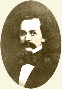
Qualchan was a 19th-century Yakama chieftain who participated in the Yakama War with his cousin Kamiakin and other chieftains.

<span class="mw-page-title-main">Battle of Pine Creek</span> 1858 battle fought in Washington

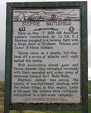
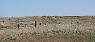
The Battle of Pine Creek, also known as the Battle of Tohotonimme and the Steptoe Disaster, was a conflict between United States Army forces under Brevet Lieutenant Colonel Edward Steptoe and members of the Coeur d'Alene, Palouse and Spokane Native American tribes. It took place on May 17, 1858, near what is present-day Rosalia, Washington. The Native Americans were victorious.

<span class="mw-page-title-main">Edward Steptoe</span> American army officer (1815–1865)

Edward Jenner Steptoe was an officer in the United States Army who served in the Mexican-American War and the Indian Wars. He is primarily remembered for his defeat at the Battle of Pine Creek during the Spokane-Coeur d'Alene-Paloos War. It was at Pine Creek where Steptoe and 164 men were ambushed by over 1,000 Indian warriors. The battle, and the subsequent (successful) retreat, is also known as "the Steptoe Disaster."

Fort Taylor was a temporary Army post during 1858 in Washington Territory, on a site in present-day Columbia County, eastern Washington.

<span class="mw-page-title-main">Battle of Spokane Plains</span> 1858 battle fought in Washington

The Battle of Spokane Plains was a battle during the Coeur d'Alene War of 1858 in the Washington Territory in the United States. The Coeur d'Alene War was part of the Yakima War, which began in 1855. The battle was fought west of Fort George Wright near Spokane, Washington, between elements of the United States Army and a coalition of Native American tribes consisting of Kalispel, Palus, Schitsu'umsh, Spokan, and Yakama warriors.

Idaho v. United States, 533 U.S. 262 (2001), was a United States Supreme Court case in which the Court held that the United States, not the state of Idaho, held title to lands submerged under Lake Coeur d'Alene and the St. Joe River, and that the land was held in trust for the Coeur d'Alene Tribe as part of its reservation, and in recognition of the importance of traditional tribal uses of these areas for basic food and other needs.

<span class="mw-page-title-main">Fort Colville</span>

Fort Colville was a U.S. Army post in the Washington Territory located three miles (5 km) north of current Colville, Washington. During its existence from 1859 to 1882, it was called "Harney's Depot" and "Colville Depot" during the first two years, and finally "Fort Colville". Brigadier General William S. Harney, commander of the Department of Oregon, opened up the district north of the Snake River to settlers in 1858 and ordered Brevet Major Pinkney Lugenbeel, 9th Infantry Regiment to establish a military post to restrain the Indians lately hostile to the U. S. Army's Northwest Division and to protect miners who flooded into the area after first reports of gold in the area appeared in Western Washington newspapers in July 1855.

The Fort Walla Walla–Fort Colville Military Road was built in June 1859 to connect the Walla Walla area with its fairly easy access to the Columbia River to the mountainous area of the Huckleberry and Selkirk Mountains of current Northeast Washington and the Inland Northwest. Brigadier General William S. Harney, commander of the Department of Oregon, opened up the district north of the Snake River to settlers in 1858 and ordered Brevet Major Pinkney Lugenbeel, 9th Infantry Regiment to establish a U.S. Army post to restrain the Indians perceived as hostile to the U.S. Army's Northwest Division and to protect miners who traveled to the area after first reports of gold in the area appeared in Western Washington newspapers in July 1855.

References