
Nisbet is a small hamlet on the B6400, in Roxburghshire, along the River Teviot, in the Scottish Borders area of Scotland. It is located 5.5 kilometres (3.4 mi) north of Jedburgh and 5 kilometres (3.1 mi) south of Roxburgh.

Mordington is an agricultural parish in the extreme south-east of Berwickshire in the Scottish Borders region. It is five miles from Berwick-upon-Tweed and borders Northumberland to the east, and south, Foulden to the west, and Lamberton to the north. The parish is bisected by the A6105 Berwick to Duns road. The lower part of the parish is covered by the Edrington estate. It is possibly the warmest parish in Scotland; the annual hours of sunshine are said to be almost as high as at Dunbar, which records the most hours in Scotland.
Holydean Castle was a castle sited near Melrose in Bowden, 1.25 miles SW of the village, in the Scottish Borders region of Scotland, and the former Roxburghshire.

Eccles is a village and agricultural parish near Kelso in Berwickshire in the Scottish Borders area of Scotland. The village is conjoined with Birgham and Leitholm.
Polwarth is a village and parish in the Scottish Borders area of Scotland. It is located at grid reference NT745502, between Greenlaw and Duns, in the former county of Berwickshire.

Bonkyl Church is a Church of Scotland kirk situated at grid reference NT808595 5 miles northeast of Duns in the old county of Berwickshire. The nearest hamlet is Preston just over 2 miles to the south-west.
Smailholm is a small village in the historic county of Roxburghshire in south-east Scotland. It is at grid reference NT648364 and straddles the B6397 Gordon to Kelso road. The village is almost equidistant from both, standing 6 miles (10 km) northwest of the abbey town of Kelso. Since local government reorganisation in Scotland in the early 1970s, Smailholm has been part of the Scottish Borders Council.
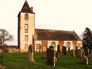
Ladykirk is a village on the B6470 in the Scottish Borders area of Scotland, and the former Berwickshire, just north of the River Tweed and the Anglo-Scottish border. The town was formerly known as Upsettlington, but King James IV of Scotland renamed the town Ladykirk; the church is also known as St Mary's Church or Kirk of Steill. Ladykirk stands directly opposite Norham Castle, Northumberland, England
Leitholm is a village in the Scottish Borders area of Scotland, 4 miles (6.4 km) north-west of Coldstream, in the former county of Berwickshire.

Legerwood is a village by the Eden Water, in the Scottish Borders area of Scotland, near Lauder, near the Southern Upland Way.
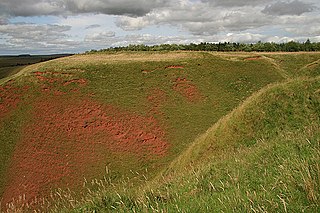
The Blackcastle Rings are earthworks and a promontory fort in the Parish of Greenlaw, above the left bank of the Blackadder Water, in the Scottish Borders area of Scotland.

Horsburgh Castle, also known as Horsbrugh Castle or Horsbrugh Tower, is a ruined tower house castle by the River Tweed, on the A72 road from Peebles to Galashiels, near Glentress in the Scottish Borders area of Scotland. The ruins date from the 16th century and was built by the Horsburghs.

Clintmains is a village by the River Tweed, in the parish of Mertoun, to the east of Newtown St Boswells, in the Scottish Borders area of Scotland, in the former county of Berwickshire.
Allanbank is a village near Allanton, in the Scottish Borders area of Scotland, in the historic county of Berwickshire.

Crailinghall is a village near Oxnam in the Scottish Borders area of Scotland, in the former Roxburghshire.

The Crosshall Cross is a cross at Crosshall Farm, Eccles, in the Scottish Borders area of Scotland, in historic Berwickshire.
Darnhall Mains is a farm and settlement off the A703, near Eddleston and the Eddleston Water in the Scottish Borders area of Scotland, in the former Peeblesshire.

Ettleton is a village near Castleton, in the Scottish Borders area of Scotland, in the former Roxburghshire.

Yetholm Loch is a loch near Kelso, in the Scottish Borders area of Scotland, in the former Roxburghshire.
Gordon Moss is a nature reserve near Gordon, in the Scottish Borders area of Scotland, in the former Berwickshire.
