
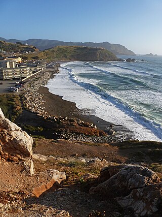
Devil's Slide is a coastal promontory in California, United States. It lies on the San Mateo County coast between Pacifica and Montara. Its name comes from the rocky edges prone to accident.
Devil's Slide is a coastal promontory in California, United States. It lies on the San Mateo County coast between Pacifica and Montara. Its name comes from the rocky edges prone to accident.
Devil's Slide is a name given to a steep, rocky coastal promontory located about midway between Montara and the Linda Mar District of Pacifica. The terrain is characterized by steep, eroded slopes with natural gradients ranging between 30 and 50%. There are small coastal valleys throughout along the major drainages within the Montara Mountain watershed. The soils in these valleys are deep and moderately well-drained and have developed along the low terraces and alluvial fans of the stream channels.
The climate of the area is Mediterranean with a strong maritime influence. The temperature range is narrow both seasonally and diurnally, while air moisture is relatively high. Extremely dense northern coastal scrub covers most of the locale, especially over San Pedro Mountain and along the steeper foot slopes of Montara Mountain. Small grassy openings and barren rocky areas are scattered throughout the scrub areas. The inland area holds other types of vegetation including aquatic and coastal freshwater marshes/seeps, willow riparian scrub, coastal grassland, non-native forest, and pasture/ranch uses/non-native brushland. The endangered species Hickman's potentilla occurs on the slopes above Martini Creek at up to 430 feet (130 m) elevation.

Immediately east of Devil's Slide is a former stretch of California State Route 1, famous for closures and landslides, which also was called "Devil's Slide". Construction of the road began in 1935 and was completed in 1936, replacing the steep, narrow, and winding Pedro Mountain Road. It was known for landslides and erosion that often occur during winter storms, sometimes making the road impassable.
Devil's Slide was originally part of Ocean Shore Railroad that was proposed between San Francisco to Santa Cruz. [1]
The first major landslide destroyed much of the road in 1940. Another large slide in 1995 forced the road's closure for almost two years. In April 2006, the road began to develop large longitudinal cracks in the roadbed, indicating an imminent slide and forcing the highway's closure for five months as CalTrans worked to stabilize the slide.
On March 25, 2013, Caltrans shut down the landslide-prone coastal road, replacing it with the Tom Lantos Tunnels, which take the highway through the promontory behind the precarious cliffs. [2] On March 27, 2014, the 1.3-mile (2.1 km)-long Devil's Slide Trail was opened to pedestrians and bicyclists, [3] taking over the section of roadway formerly used by State Route 1 and now bypassed by the new tunnels. [4] The total cost to convert the highway into a trail was US$1,991,525(equivalent to $2,502,000 in 2022). [3]
Devil's Slide was used in a key scene of the 1960 thriller Portrait in Black with Lana Turner and Anthony Quinn. Turner and Quinn portrayed doomed lovers who deliberately pushed a car, containing the body of a murdered man, over the edge of the cliff. The Universal crew obtained permission from the State of California to stage the scene, which involved retrieving the car from the bottom of the cliff once the scene had been successfully filmed. The San Mateo Times printed a photograph of the filming of this sequence. [5]

Devil's Slide was the location of a military triangulation station and observation site used during World War II as part of the harbor defense of San Francisco. Prior to the advent of radar, military personnel used binoculars and compasses to search for ships at sea and relay their coordinates to a central post. By combining information from multiple observation posts, a ship's precise location could be determined by triangulation. There were six military structures at the Devil's Slide: three concrete and steel observation pill-boxes, two concrete-and-earth bunkers, and a reinforced steel observation tower. The pill-boxes were used as hardened observation posts, and one of the bunkers was used as a communications and command post. [6] The southernmost bunker site was sold to a private owner in 1983, but some of the exposed structure remains.

State Route 1 (SR 1) is a major north–south state highway that runs along most of the Pacific coastline of the U.S. state of California. At 656 miles (1,056 km), it is the longest state route in California, and the second-longest in the US after Montana Highway 200. SR 1 has several portions designated as either Pacific Coast Highway (PCH), Cabrillo Highway, Shoreline Highway, or Coast Highway. Its southern terminus is at Interstate 5 (I-5) near Dana Point in Orange County and its northern terminus is at U.S. Route 101 (US 101) near Leggett in Mendocino County. SR 1 also at times runs concurrently with US 101, most notably through a 54-mile (87 km) stretch in Ventura and Santa Barbara counties, and across the Golden Gate Bridge.

San Mateo County, officially the County of San Mateo, is a county located in the U.S. state of California. As of the 2020 census, the population was 764,442. Redwood City is the county seat, and the third most populated city following Daly City and San Mateo. San Mateo County is included in the San Francisco–Oakland–Berkeley, CA MSA, Silicon Valley, and is part of the San Francisco Bay Area, the nine counties bordering San Francisco Bay. It covers most of the San Francisco Peninsula. San Francisco International Airport is located in the northeastern area of the county and is approximately 7 miles south of the city and county limits of San Francisco, even though the airport itself is assigned a San Francisco postal address. The county's built-up areas are mostly suburban, and are home to several corporate campuses.

Montara is a census-designated place (CDP) in San Mateo County, California, United States. The population was 2,833 at the 2020 census. Nearby communities include Moss Beach and Princeton-by-the-Sea.

El Camino Real is a 600-mile (965-kilometer) commemorative route connecting the 21 Spanish missions in California, along with a number of sub-missions, four presidios, and three pueblos. Historically associated with the Calle Real which terminates in Mexico City, as the former capital of New Spain and the seat of royal power for Las Californias, its southern end in the modern U.S. state of California is at Mission San Diego de Alcalá and its northern terminus is at Mission San Francisco Solano.

Fitzgerald Marine Reserve is a marine reserve in California on the Pacific Ocean, located just north of Pillar Point Harbor and Mavericks in the San Mateo County community of Moss Beach. Moss Beach is located approximately 20 miles (32 km) south of San Francisco and 50 miles (80 km) north of Santa Cruz. The reserve is a 32-acre (0.13 km2) holding which extends from Montara light station at the north to Pillar Point on the south. The reserve consists of a three-mile stretch of beach, tidepool habitat, marsh, erosive bluffs, clifftop trail and cypress and eucalyptus forests. The property is owned by the State of California and managed by San Mateo County as a county park and nature preserve. The reserve is administratively assigned to be part of the Monterey Bay National Marine Sanctuary. Adjacent to and possibly within the reserve is an endangered species of butterfly, the San Bruno elfin butterfly.

U.S. Route 101 (US 101) is a major north–south United States Numbered Highway, stretching from Los Angeles, California, to Tumwater, Washington. The California portion of US 101 is one of the last remaining and longest U.S. Routes still active in the state, and the longest highway of any kind in California. US 101 was also one of the original national routes established in 1926. Significant portions of US 101 between the Los Angeles area and the San Francisco Bay Area follow El Camino Real, the commemorative route connecting the former Alta California's 21 missions.
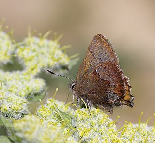
The San Bruno elfin is a U.S. federally listed endangered subspecies that inhabits rocky outcrops and cliffs in coastal scrub on the San Francisco Peninsula. It is endemic to this habitat in California. Its patchy distribution reflects that of its host plant, broadleaf stonecrop.
Rockaway Beach is a shoreline area of the Pacific Ocean in the southern portion of Pacifica, California, United States, approximately 7 miles (11 km) south of the city of San Francisco. It is located within a gently curving embayment with direct access via Rockaway Beach Avenue and providing easy access to Highway 1.

Mussel Rock is a rock formation on the coast of San Mateo County, California, offshore from Daly City. It consists of one large and numerous smaller rocks of a type known as a stack, where a headland is eroded unevenly, leaving small islands. The rock itself is located 15 meters from the shore of Mussel Rock Park and stands 18 meters tall.
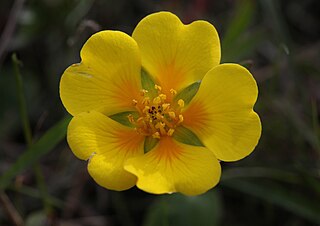
Potentilla hickmanii is an endangered perennial herb of the rose family. This rare plant species is found in a narrowly restricted range in two locations in coastal northern California, in Monterey County, and in very small colonies in San Mateo County. This small wildflower, endemic to western slopes of the outer coastal range along the Pacific Ocean coast, produces bright yellow blossoms through spring and summer.
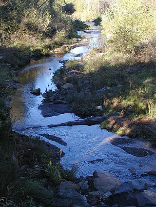
Martini Creek is a coastal stream whose watershed lies entirely within San Mateo County, California, United States on the western exposures of the Montara mountain block, discharging to the Pacific Ocean. It flows about 2 miles (3 km) from its source on Montara Mountain to its mouth in Montara State Beach. This stream has a drainage basin composed of open space and agricultural lands. Some of the basin has moderate to steep slopes and much of the basin habitat is northern coastal scrub, and in places almost of a pygmy forest nature.

Montara State Beach is a beach located in the coastal region of the U.S. state of California, eight miles north of Half Moon Bay on State Route 1. It is operated by the California State Department of Parks and Recreation under the San Mateo Coast Sector Office. It is one of the cleanest beaches in the state and is known for surfing and fishing.

The Ocean Shore Railroad was a railroad built between San Francisco and Tunitas Glen, and Swanton and Santa Cruz that operated along the Pacific coastline from 1905 until 1921. The route was originally conceived to be a continuous line between San Francisco and Santa Cruz, but the 1906 San Francisco Earthquake, financial difficulties, and the advent of the automobile caused the line to never reach its goals, and remain with a Northern and Southern division.

Pedro Mountain Road describes a series of historical road crossings of Pedro Mountain, a promontory ridge located between Montara Mountain and the coastal cliffs of Devil's Slide in San Mateo County, California. This Pedro Mountain headland blocks the easy passage of coastal travelers between the Pedro Valley in Pacifica, California and Montara, California. The most prominent of these Pedro Mountain roads was Coastside Boulevard, the 1914 to 1937 coastal highway 57, which remains in use today as part of the trail network of McNee Ranch State Park.

Montara Mountain, positioned between the unincorporated community of Montara, California, to the southwest and the city of Pacifica, California, to the north, forms the northern spur of the Santa Cruz Mountains, a narrow mountain range running the length of the San Francisco Peninsula that separates San Francisco Bay from the Pacific Ocean. Its highest point rises to 1,898 feet (579 m) above sea level. Montara and Pacifica are connected by the Tom Lantos Tunnels, which run through the Mountain.
The Waldo Grade is a highway grade between the Golden Gate Bridge and Marin City along U.S. Route 101 and State Route 1. It is defined as the stretch of roadway between the Spencer Offramp and Marin City, within the city of Sausalito. This grade is traversed by a full freeway multi-lane highway facility. This portion of US 101/SR 1 is an important link in surface transportation connecting the city of San Francisco to Marin County and the North Bay. Nearby locations to the Waldo Grade include: the city of Sausalito, the U.S. Army Corps of Engineers Bay Model, The Marine Mammal Center and the Golden Gate National Recreation Area. It, and nearby Waldo Point along Richardson Bay between Sausalito and Mill Valley, is named after 1850s California politician William Waldo.
San Pedro Creek is a perennial stream in the City of Pacifica, San Mateo County, California in the San Francisco Bay Area whose tributaries originate on Sweeney Ridge in the Golden Gate National Recreation Area and Montara Mountain in the Santa Cruz Mountains.The creek mainstem flows 2.5 miles (4.0 km) through the San Pedro Valley to its mouth near Shelter Cove of the Pacific Ocean The stream is notable as the 1769 campsite for Gaspar de Portolà before he ascended Sweeney Ridge and discovered San Francisco Bay.

The Tom Lantos Tunnels are two tunnels located within the coastal promontory of Montara Mountain, on the San Francisco Peninsula in California, United States, created to allow rerouting State Route 1 to avoid a portion of roadway known as Devil's Slide. They are officially named after late Congressman Tom Lantos, who was instrumental in securing funding for the project, but de facto named after their location.
Big Sur Coast Highway is a section of California State Route 1 through the Big Sur region of California that is widely considered to be one of the most scenic driving routes in the United States, if not the world. It is both a National Scenic Highway and a California Scenic Highway, and was described by Australian painter Francis McComas as the "greatest meeting of land and water in the world". Condé Nast Traveler named State Route 1 through Big Sur one of the top ten world-famous streets, comparable to Broadway in New York City and the Champs-Élysées in Paris. The road itself is a destination for visitors.
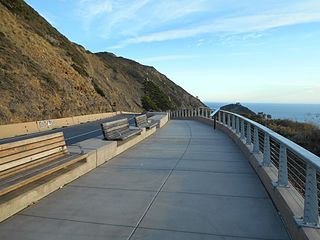
The Devil's Slide Trail is a hiking trail between Pacifica, California and Montara, California in the San Francisco Bay Area. The trail is a segment in the California Coastal Trail, which stretches from Oregon to Mexico.