Tasks and operations
The primary task of the Dutch Hydrographic Service is to provide tools for safe navigation in Dutch waters.
Highly frequented routes require more attention than less frequented parts of the North Sea and are thus being surveyed at least every two years (some areas in the Rotterdam approach even annually) Above that the southern part of the Dutch North Sea which attracts most of the traffic is covered with sandy shoals forming a great risk for deep-draught vessels. The important fairways to Rotterdam and IJmuiden are maintained and surveyed by the North Sea Service (Dienst Noordzee) of the Rijkswaterstaat.
The data of soundings and the information concerning obstacles is compiled by the Dienst der Hydrografie in The Hague together with information from other sources. Charts in the A0 format are produced mainly for merchant shipping. Additionally, there are charts of the so-called 1800 series in the A2 format for recreational shipping.
Other publications are the "Netherlands Coast Pilot" (HP1) describing the coasts and harbours of the Dutch coast and the tide tables and tidal stream atlas (HP33).
Changes important for shipping concerning buoys, wrecks etc. are published in the weekly Berichten aan Zeevarenden (Dutch Notice to Mariners) in order to provide for the update of charts and pilots.

Hydrography is the branch of applied sciences which deals with the measurement and description of the physical features of oceans, seas, coastal areas, lakes and rivers, as well as with the prediction of their change over time, for the primary purpose of safety of navigation and in support of all other marine activities, including economic development, security and defense, scientific research, and environmental protection.

The Royal Netherlands Navy is the naval force of the Kingdom of the Netherlands. Its origins date back to the Eighty Years' War (1568–1648), the war of independence from the House of Habsburg who ruled over the Habsburg Netherlands.

The Canadian Hydrographic Service (CHS) is part of the federal department of Fisheries and Oceans Canada and is Canada's authoritative hydrographic office. The CHS represents Canada in the International Hydrographic Organization (IHO).

The National Geodetic Survey (NGS), formerly the United States Survey of the Coast (1807–1836), United States Coast Survey (1836–1878), and United States Coast and Geodetic Survey (USC&GS) (1878–1970), is a United States federal agency that defines and manages a national coordinate system, providing the foundation for transportation and communication; mapping and charting; and a large number of applications of science and engineering. Since its foundation in its present form in 1970, it has been part of the National Oceanic and Atmospheric Administration (NOAA), of the United States Department of Commerce.

The United Kingdom Hydrographic Office (UKHO) is the UK's agency for providing hydrographic and marine geospatial data to mariners and maritime organisations across the world. The UKHO is a trading fund of the Ministry of Defence (MoD) and is located in Taunton, Somerset, with a workforce of approximately 900 staff.

A research vessel is a ship or boat designed, modified, or equipped to carry out research at sea. Research vessels carry out a number of roles. Some of these roles can be combined into a single vessel but others require a dedicated vessel. Due to the demanding nature of the work, research vessels are often constructed around an icebreaker hull, allowing them to operate in polar waters.

CCGS Labrador was a Wind-class icebreaker. First commissioned on 8 July 1954 as Her Majesty's Canadian Ship (HMCS) Labrador in the Royal Canadian Navy (RCN), Captain O.C.S. "Long Robbie" Robertson, GM, RCN, in command. She was transferred to the Department of Transport (DOT) on 22 November 1957, and re-designated Canadian Government Ship (CGS) Labrador. She was among the DOT fleet assigned to the nascent Canadian Coast Guard (CCG) when that organization was formed in 1962, and further re-designated Canadian Coast Guard Ship (CCGS) Labrador. Her career marked the beginning of the CCG's icebreaker operations which continue to this day. She extensively charted and documented the then-poorly-known Canadian Arctic, and as HMCS Labrador was the first ship to circumnavigate North America in a single voyage. The ship was taken out of service in 1987 and broken up for scrap in 1989.

INS Darshak (J21) is a hydrographic survey ship in the Indian Navy, under the Eastern Naval Command.

Coastal defence ships were warships built for the purpose of coastal defence, mostly during the period from 1860 to 1920. They were small, often cruiser-sized warships that sacrificed speed and range for armour and armament. They were usually attractive to nations that either could not afford full-sized battleships or could be satisfied by specially designed shallow-draft vessels capable of littoral operations close to their own shores. The Nordic countries and Thailand found them particularly appropriate for their island-dotted coastal waters. Some vessels had limited blue-water capabilities; others operated in rivers.
The Danish Maritime Safety Administration (DaMSA) was a department of the Danish Ministry of Defence with administration located in Christianshavn, Copenhagen. DaMSA operated throughout Denmark as part of the Danish Search and Rescue (SAR) organization that runs 21 rescue stations located along the coasts of Denmark.

HMCS Cartier was a commissioned surveying ship of the Royal Canadian Navy and saw service during World War I and World War II.
The Naval Oceanographic Office (NAVOCEANO), located at John C. Stennis Space Center in south Mississippi, comprises approximately 1,000 civilian, military and contract personnel responsible for providing oceanographic products and services to all elements within the Department of Defense.
Behr Paima is a hydrographic survey and Research vessel owned by Pakistan Navy. Her keel was laid on 16 February 1982 and was launched on 7 July 1982 in Japan. The ship was handed over to Pakistan Navy on 27 December, same year. The ship was equipped with most modern surveying systems of the time. The hydrographic systems have been upgraded since then from time to time and hence are parallel with modern trends and techniques available in the world. Most of the oceanographic equipments are, however, of the original outfit.

CSS Acadia is a former hydrographic surveying and oceanographic research ship of the Hydrographic Survey of Canada and its successor the Canadian Hydrographic Service.
The Australian Hydrographic Service is the Australian Commonwealth Government agency responsible for providing hydrographic services that meet Australia's obligations under the SOLAS convention and the national interest; enabling safe navigation, maritime trade and supporting protection of the marine environment. The agency, headquartered at the Australian Hydrographic Office in Wollongong, New South Wales, is an element of the Royal Australian Navy (RAN), and serves both military and civilian functions. The names Australian Hydrographic Service and the Australian Hydrographic Office are commonly abbreviated as AHS or AHO respectively.

USS Hannibal (AG-1) was launched 9 March 1898 as the 1,785 GRT steamer Joseph Holland of London. The ship was laid down at as North Dock yard hull 143 for F. S. Holland, London, by J. Blumer & Company at Sunderland, England. Completion was in April 1898.
The United States Hydrographic Office prepared and published maps, charts, and nautical books required in navigation. The office was established by an act of 21 June 1866 as part of the Bureau of Navigation, Department of the Navy. It was transferred to the Department of Defense on 10 August 1949. The office was abolished on 10 July 1962, replaced by the Naval Oceanographic Office.
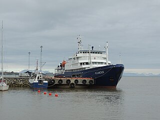
MV Plancius, formerly HNLMS Tydeman (A906), is a renovated oceanographic research vessel of the Royal Netherlands Navy now employed as a polar expedition cruise vessel by owner and operator Oceanwide Expeditions. She was put into service on 10 November, 1976, and served until 3 June, 2004, before being renovated for commercial use. Thirty percent of her operational time was used by non-military research institutes and universities. At the time, HNLMS Tydeman and the smaller ships HNLMS Buyskes and HNLMS Blommendal, formed the so-called “white fleet” of the Hydrographic Service of the Royal Netherlands Navy.[1] The white fleet was replaced by HNLMS Snellius (A802) in 2003 and HNLMS Luymes (A803) in 2004.[2]

The Russian Hydrographic Service, full current official name Department of Navigation and Oceanography of the Ministry of Defence of the Russian Federation, is Russia's hydrographic office, with responsibility to facilitate navigation, performing hydrographic surveys and publishing nautical charts.

Fijenoord was a shipbuilding and machine factory in Rotterdam the Netherlands from 1823 to 1929. In 1929 it merged with Wilton to become Wilton-Fijenoord.

