Elk Neck Peninsula (center) in 2020Facing south toward the confluence of Elk and Bohemia Rivers, from Elk Neck Peninsula, c. 1898
Elk Neck Peninsula is in Cecil County, Maryland, between the towns of Elkton and North East, Maryland. Native American and colonial travelers often canoed or sailed up the Chesapeake Bay to Elkton, where the Elk River became unnavigable, and then walked or took some form of surface transportation to the Delaware Bay watershed, since this was the shortest surface crossing. Native Americans of the area, including the Nanticoke and Lenni Lenape, hunted and fished, as well as established semi-permanent camps.
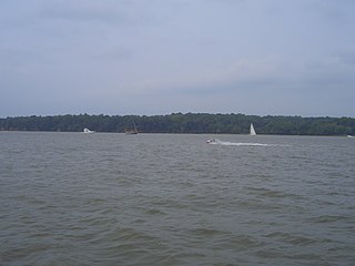
Elk Neck State Park includes the southern tip of the peninsula, bounded by the North East River, Elk River, as well as the Chesapeake Bay. Maryland Route 272 ends at the point of the peninsula, with the famous Turkey Point Light. Much of the peninsula's land is legally protected from development, either as part of the state park or as part of Elk Neck State Forest. Deep forests, bluffs, beaches and marshlands are the primary natural features of the park's landscape.
Cecil County is a county located in the U.S. state of Maryland at the northeastern corner of the state, bordering both Pennsylvania and Delaware. As of the 2020 census, the population was 103,725. The county seat is Elkton. The county was named for Cecil Calvert, 2nd Baron Baltimore (1605–1675), the first Proprietary Governor of the Province (colony) of Maryland. With the eastern part of the county being closer to Philadelphia than to Baltimore, it is part of the Philadelphia-Camden-Wilmington, PA-NJ-DE-MD Metropolitan Statistical Area. The county is located in Wilmington's Radio Market and Baltimore's Designated Market Area.
The Delmarva Peninsula, or simply Delmarva, is a large peninsula and proposed state on the East Coast of the United States, occupied by the vast majority of the state of Delaware and parts of the Eastern Shore regions of Maryland and Virginia. The peninsula is 170 miles (274 km) long. In width, it ranges from 70 miles (113 km) near its center, to 12 miles (19 km) at the isthmus on its northern edge, to less near its southern tip of Cape Charles. It is bordered by the Chesapeake Bay on the west, Pocomoke Sound on the southwest, and the Delaware River, Delaware Bay, and the Atlantic Ocean on the east.
Arnold, a census-designated place (CDP) in Anne Arundel County, Maryland, United States, located just outside of the state's capital, Annapolis. It is located 18.78 miles south of Baltimore, and 29.97 miles east of Washington, D.C. The population was 23,106 at the 2010 census. Neighborhoods straddle College Parkway and Maryland Route 2. Arnold is located on the scenic Broadneck Peninsula. The ZIP code is 21012. It is bordered by Severna Park to the northwest, Cape Saint Claire to the southeast, Annapolis to the southwest, and Lake Shore to the northeast.
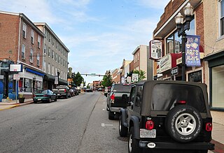
Elkton is a town in and the county seat of Cecil County, Maryland, United States. The population was 15,443 at the 2010 census. It was formerly called Head of Elk because it sits at the head of navigation on the Elk River, which flows into the nearby Chesapeake Bay.
North East is a town in Cecil County, Maryland, United States. It is located between Philadelphia and Baltimore. The population was 3,572 at the 2010 census.
Tidewater refers to the north Atlantic Plain region of the United States.
The Wicomico River is a 24.4-mile-long (39.3 km) tributary of the Chesapeake Bay on the eastern shore of Maryland. It drains an area of low marshlands and farming country in the middle Delmarva Peninsula.
The Eastern Shore of Maryland is a part of the U.S. state of Maryland that lies mostly on the east side of the Chesapeake Bay. Nine counties are normally included in the region. The Eastern Shore is part of the larger Delmarva Peninsula that Maryland shares with Delaware and Virginia.
The Sassafras River is a tributary of the Chesapeake Bay on the Delmarva Peninsula in the United States. It is approximately 22 miles (35 km) long and starts in western New Castle County, Delaware, and along the boundary between Cecil County, Maryland on the north and Kent County, Maryland on the south. It rises southwest of Middletown, Delaware and ends at the Chesapeake Bay in a wide mouth between Howell Point near Betterton, Maryland and Grove Point on Grove Neck.
The Bohemia River is a 4.7-mile-long (7.6 km) tributary of the Elk River on the Delmarva Peninsula. It is located in Cecil County, Maryland, with its headwaters extending into New Castle County, Delaware.
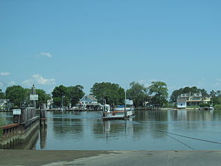
The Elk River is a tidal tributary of the Chesapeake Bay on the Eastern Shore of Maryland and on the northern edge of the Delmarva Peninsula. It is about 15 miles (24 km) long. As the most northeastern extension of the Chesapeake Bay estuary, it has served as one entrance to the Chesapeake & Delaware Canal since the 19th century. The canal and river now serve as one boundary of the Elk Neck Peninsula. The river flows through Cecil County, Maryland, with its watershed extending into New Castle County, Delaware and Chester County, Pennsylvania. Elkton, the county seat of Cecil County, is located at its head. Its total watershed area is 143 square miles (370 km2), with 21 square miles (54 km2) of open water, so its watershed is 15% open water. It is south and east of the North East River, and north of the Sassafras River.
Maryland Route 272 is a state highway in the U.S. state of Maryland. The state highway runs 20.67 miles (33.27 km) from Turkey Point within Elk Neck State Park north through North East to the Pennsylvania state line near Calvert, where the highway continues as Pennsylvania Route 272. MD 272 is the main north–south highway of central Cecil County, connecting the Elk Neck Peninsula between the North East River and Elk River with U.S. Route 40 and Interstate 95 (I-95) in North East, MD 273 in Calvert, and Rising Sun via MD 274. The section of MD 272 between North East and Bay View was paved by 1910. The remainder of the state highway north to Calvert and south to Elk Neck was completed in several sections in the 1930s. The first relocations of MD 272 occurred when both railroads near North East were bridged in the early 1940s and mid-1950s. Multiple relocations occurred in the late 1950s and early 1960s along the whole length of the highway to eliminate curves and tie the state highway into I-95. MD 272 reached its current extent when it was extended south into Elk Neck State Park in 1979.
The Mason-Dixon Trail is a 193-mile (311 km) hiking trail that begins at the Appalachian Trail in south-central Pennsylvania, continues through northeastern Maryland and northern Delaware, and re-enters Pennsylvania shortly before ending at Chadds Ford. It is named for the historic Mason–Dixon line, which it crosses twice. About one-third of the route follows roads through rural areas, but the rest is on traditional footpaths. The trail also traverses many tracts of private land, at which passage for hikers has been arranged with owners. This results in occasional relocations. The trail takes hikers through a variety or rural and semi-urban landscapes, with most of the route in Pennsylvania featuring farmlands and forested areas, and most of the route in Maryland and Delaware featuring historic sites and small towns.
Elk Neck State Park is a public recreation area located between Chesapeake Bay and the Elk River near the southern tip of the Elk Neck Peninsula in Cecil County, Maryland. The state park is home to the historic Turkey Point Light and offers land-based and water-based recreation. The park is located on MD 272, eight miles (13 km) south of the town of North East, and 13 miles (21 km) south of exit 100 on I-95. It is operated by the Maryland Department of Natural Resources.
Cecil County Public Schools is a public school system serving the residents of Cecil County, Maryland. Demographics, assessments, and statistics are available on the Maryland Report Card website.
The Little Magothy River runs 2.5 miles (4.0 km) through Anne Arundel County in the U.S. state of Maryland. It is located southeast of the Magothy River, just outside its mouth and north of the Severn River.
Fort Howard is an unincorporated community and census-designated place in Baltimore County, Maryland, United States. The population was 303 at the 2010 census. The median age is 47.9. 52.86% are female and 47.14% are male. 58.9% are married and 41.1% are single. The average household size is 2.64.
Red Point is an unincorporated community located just off Maryland Route 272 south of North East, Maryland, United States. It is near Elk Neck State Park, where the North East River enters Chesapeake Bay.
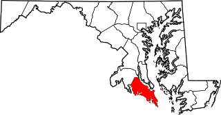
St. Mary's Peninsula is part of the Western Shore region of Maryland. From the Charles County line, just north of Charlotte Hall, Maryland, to the southern tip of St. Mary's County at Point Lookout State Park, St. Mary's Peninsula stretches about 39 miles (63 km). It is bordered on the southwest by the Potomac River, on the north and east by the Patuxent River and on the east by Chesapeake Bay. From the end of these two rivers, the peninsula has about 15 miles of shoreline along the Bay's western shore from Lexington Park, Maryland to Point Lookout. Its shoreline stretches for a total of 536 miles along the Patuxent River, Potomac River and the Chesapeake Bay.
The Broadneck Peninsula is an area in Anne Arundel County, Maryland. The area is north of the Severn River, south of the Magothy River and west of the Chesapeake Bay. At the lower end of the Broadneck Peninsula is the 4.3 mile Chesapeake Bay Bridge.
This page is based on this Wikipedia article Text is available under the CC BY-SA 4.0 license; additional terms may apply. Images, videos and audio are available under their respective licenses.