
Hoover Dam is a concrete arch-gravity dam in the Black Canyon of the Colorado River, on the border between the U.S. states of Nevada and Arizona. It was constructed between 1931 and 1936 during the Great Depression and was dedicated on September 30, 1935, by President Franklin D. Roosevelt. Its construction was the result of a massive effort involving thousands of workers, and cost over one hundred lives. It was referred to as Hoover Dam after President Herbert Hoover in bills passed by Congress during its construction, but was named Boulder Dam by the Roosevelt administration. The Hoover Dam name was restored by Congress in 1947.

The United States Army Corps of Engineers (USACE) is an engineer formation of the United States Army that has three primary mission areas: engineer regiment, military construction, and civil works. The day-to-day activities of the three mission areas are administered by a lieutenant general known as the commanding general/chief of engineers. The chief of engineers commands the engineer regiment, composed of combat engineer army units, and answers directly to the chief of staff of the army. Combat engineers come from throughout the service and can be active duty, national guard, or army reserve. Combat engineers' duties are to construct fighting positions, fixed/floating bridges, and obstacles and defensive positions, place and detonate explosives (sappers), conduct operations that include route clearance of obstacles and rivers, prepare and install firing systems for demolition and explosives, and detect mines. For the military construction mission the commanding general is directed and supervised by the Assistant Secretary of the Army for installations, environment, and energy, whom the President appoints and the Senate confirms. Military construction relates to construction on military bases and worldwide installations.

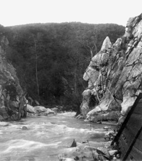
The St. Francis Dam was a concrete gravity dam built from 1924 to 1926 to serve Los Angeles' growing water needs, that catastrophically failed in 1928 due to a defective soil foundation, claiming the lives of at least 431 people. The collapse of the St. Francis Dam is considered to be one of the worst American civil engineering disasters of the 20th century and remains the second-greatest loss of life in California's history, after the 1906 San Francisco earthquake and fire.

Lake Strom Thurmond, officially designated J. Strom Thurmond Reservoir at the federal level, and Clarks Hill Lake by the state of Georgia, is a reservoir at the border between Georgia and South Carolina in the Savannah River Basin.
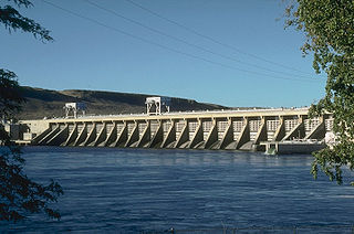
McNary Dam is a 1.4-mile (2.2-km) long concrete gravity run-of-the-river dam which spans the Columbia River. It joins Umatilla County, Oregon with Benton County, Washington, 292 miles (470 km) upriver from the mouth of the Columbia. It is operated by the U.S. Army Corps of Engineers' McNary Lock and Dam office. The dam is located a mile (2 km) east of the town of Umatilla, Oregon, and 8 miles (13 km) north of Hermiston, Oregon. The dam was originally planned to be named Umatilla Dam, but the Flood Control Act of 1945 renamed the dam in honor of Senator Charles L. McNary of Oregon, who had died the previous year.

The Sepulveda Dam is a project of the U.S. Army Corps of Engineers designed to withhold winter flood waters along the Los Angeles River. Completed in 1941, at a cost of $6,650,561, it is located south of center in the San Fernando Valley, approximately eight miles east of the river's source in the western end of the Valley, in Los Angeles, California.
The Pick-Sloan Flood Control Act of 1944, enacted in the 2nd session of the 78th Congress, is U.S. legislation that authorized the construction of numerous dams and modifications to previously existing dams, as well as levees across the United States. Among its various provisions, it established the Southeastern Power Administration and the Southwestern Power Administration, and led to the establishment of the Pick-Sloan Missouri Basin Program.

The San Gabriel River is a mostly urban waterway flowing 58 miles (93 km) southward through Los Angeles and Orange Counties, California in the United States. It is the central of three major rivers draining the Greater Los Angeles Area, the others being the Los Angeles River and Santa Ana River. The river's watershed stretches from the rugged San Gabriel Mountains to the heavily developed San Gabriel Valley and a significant part of the Los Angeles coastal plain, emptying into the Pacific Ocean between the cities of Long Beach and Seal Beach.

Tellico Dam is a dam built by the Tennessee Valley Authority (TVA) in Loudon County, Tennessee on the Little Tennessee River, just above the main stem of the Tennessee River. Completed in 1979, it impounds the Tellico Reservoir.
The Arroyo Seco, meaning "dry stream" in Spanish, is a 24.9-mile-long (40.1 km) seasonal river, canyon, watershed, and cultural area in Los Angeles County, California. The area was explored by Gaspar de Portolà who named the stream Arroyo Seco as this canyon had the least water of any he had seen. During this exploration he met the Chief Hahamog-na (Hahamonga) of the Tongva Indians.

Whittier Narrows Dam is a 56-foot tall earth dam on the San Gabriel River and the smaller, parallel Rio Hondo. The dam is located, as the name implies, at the Whittier Narrows. It provides water conservation storage and is also the central element of the Los Angeles County Drainage Area (LACDA) flood control system. Its reservoir has a capacity of 67,060 acre⋅ft (82,720,000 m3).
In the United States, there are multiple laws known as the Flood Control Act (FCA). Typically, they are enacted to control irrigation because of floods or other natural disasters and are administered by the United States Army Corps of Engineers. These laws were enacted beginning in 1917, with the most recent one being passed in 1965.
Bluestone Lake is a flood control reservoir located on the New River near Hinton, West Virginia. At its normal pool level, Bluestone Dam impounds a 10.7-mile (17.2 km) stretch of the New and its tributary, the Bluestone River. Normally approximately 2,040 acres (8.3 km2) in size, the lake can grow to over 36 miles (58 km) long at flood control pool. At higher water levels, the lake extends into Giles County, Virginia.

Burnsville Lake is both a recreational and flood control reservoir on Little Kanawha River located southeast of Burnsville in Braxton County, West Virginia. Burnsville Lake was authorized by the U.S. Congress in the Flood Control Act of 1938.

The Los Angeles flood of 1938 was one of the largest floods in the history of Los Angeles, Orange, and Riverside Counties in southern California. The flood was caused by two Pacific storms that swept across the Los Angeles Basin in February-March 1938 and generated almost one year's worth of precipitation in just a few days. Between 113–115 people were killed by the flooding. The Los Angeles, San Gabriel, and Santa Ana Rivers burst their banks, inundating much of the coastal plain, the San Fernando and San Gabriel Valleys, and the Inland Empire. Flood control structures spared parts of Los Angeles County from destruction, while Orange and Riverside Counties experienced more damage.

The Flood Control Act of 1938 was an Act of the United States Congress signed into law by President Franklin Delano Roosevelt that authorized civil engineering projects such as dams, levees, dikes, and other flood control measures through the United States Army Corps of Engineers and other Federal agencies. It is one of a number of Flood Control Acts passed nearly annually by the United States Congress.
The Flood Control Act of 1936, Pub.L. 74–738, was an Act of the United States Congress signed into law by President Franklin Delano Roosevelt on 22 June 1936. It authorized civil engineering projects such as dams, levees, dikes, and other flood control measures through the United States Army Corps of Engineers and other Federal agencies. It is one of a number of Flood Control Acts passed on a regular basis by the United States Congress. FCA 1936 was introduced in Congress by Riley J. Wilson.

Toronto Lake is a flood control lake in southeast Kansas, primarily in Woodson County. It is located on the Verdigris River about 4 miles southeast of Toronto, Kansas. The lake is maintained by the U.S. Army Corps of Engineers.
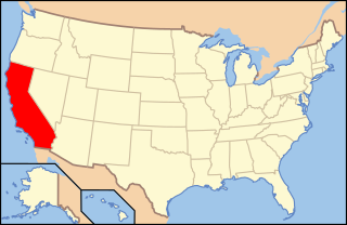
The environment of California describes results of human habitation of the American State of California.

Santa Fe Dam is a flood-control dam on the San Gabriel River located in Irwindale in Los Angeles County, California, United States. For most of the year, the 92-foot (28 m)-high dam and its reservoir lie empty, but can hold more than 45,000 acre-feet (56,000,000 m3) of water during major storms. During the dry season, the basin behind the dam is used for groundwater recharge, as well as various recreational activities.