Richmond is a town in south-west London, 8.2 miles (13.2 km) west-southwest of Charing Cross. It stands on the River Thames, and features many parks and open spaces, including Richmond Park, and many protected conservation areas, which include much of Richmond Hill. A specific Act of Parliament protects the scenic view of the River Thames from Richmond.
This article lists the islands in the River Thames, or at the mouth of a tributary, in England. It excludes human-made islands built as part of the building of forty-five two-gate locks which each accompany a weir, and islets subordinate to and forming part of the overall shape of another. The suffix -ey is common across England and Scotland and cognate with ait and meaning island, a term – as ait or eyot – unusually well-preserved on the Thames. A small minority of list entries are referred to as Island, Ait or Eyot and are vestiges, separated by a depression in the land or high-water-level gully.

Shiplake Lock is a lock and weir situated on the River Thames in England between the villages of Shiplake and Lower Shiplake, Oxfordshire. It is just above the points where the River Loddon joins the Thames and Shiplake Railway Bridge crosses the river. The first pound lock was built by the Thames Navigation Commission in 1773.
Ham is a suburban district in Richmond, south-west London. It has meadows adjoining the River Thames where the Thames Path National Trail also runs. Most of Ham is in the London Borough of Richmond upon Thames and, chiefly, within the ward of Ham, Petersham and Richmond Riverside; the rest is in the Royal Borough of Kingston upon Thames. The district has modest convenience shops and amenities, including a petrol station and several pubs, but its commerce is subsidiary to the nearby regional-level economic centre of Kingston upon Thames.
The Tideway is a part of the River Thames in England which is subject to tides. This stretch of water is downstream from Teddington Lock. The Tideway comprises the upper Thames Estuary including the Pool of London.
The A307 road runs 13.2 miles (21.2 km) through SW London and NW Surrey. It is primary at the north-east end; the remainder is non-primary, generally superseded in the mid-twentieth century in two stages by newer alignments of the Portsmouth Road, the Kingston bypass and Esher bypass of the A3, which runs along a slightly oblique axis.

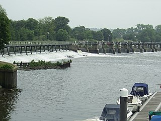
Molesey Lock is a lock on the River Thames in England at East Molesey, Surrey on the right bank.

Richmond Hill in Richmond, London, is a hill that begins gently in its townside through the former fields, orchards and vineyard to a point just within Richmond Park, the deer park emparked and enclosed by Charles I.

Old Windsor Lock is a lock on the River Thames in England on the right bank beside Old Windsor, Berkshire. The lock marks the downstream end of the New Cut, a meander cutoff built in 1822 by the Thames Navigation Commissioners which created Ham Island. The lock and a wider footbridge give access to the island. Two weirs are associated; the smaller adjoins and the larger is upstream. The lock is the ninth lowest of the forty-five on the river.

Romney Lock is a lock on the River Thames in England near Windsor and Eton, about half a mile downstream of Windsor Bridge. It is on the Windsor side of the river next to a boatyard and adjoins Romney Island, a long strip-shaped ait in the middle of the river. The first lock was built by the Thames Navigation Commission in 1798.

Sunbury Lock Ait is the ait (island) in the River Thames in England adjacent to Sunbury Lock between Walton-on-Thames, and Sunbury-on-Thames, Surrey. It is unpopulated, but accessible by a footbridge over the lock cut from a wide section of the Thames Path towpath on the southern bank as well as walkways on the lock gates. Thirdly, a walkway links to Wheatley's Ait upstream, across the weir, but this is closed to the public. The quite long, thin island is inaccessible from Sunbury-on-Thames where it faces a long section of public riverbank, a few private conservation area Victorian terraces with moorings and two pubs also with moorings.
Firework Ait is an islet in the River Thames in England on the reach above Romney Lock known as the Windsor and Eton reach, Berkshire. It is the smallest island on the Thames with an official map-published name.

Oliver's Island is a tree-covered 0.9-acre (0.36 ha) ait, in the River Thames in England. It is in the London Borough of Hounslow, on the Tideway, facing Kew and Strand-on-the-Green in the London Borough of Richmond upon Thames, and is owned by the Port of London Authority.

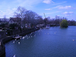
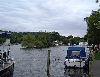
Corporation Island is a small island on the River Thames in London. The island is between Richmond Bridge and Richmond Railway Bridge, where it forms part of the celebrated view from the Richmond waterfront. Its name seems to derive from its owners, the Corporation of Richmond, now the London Borough of Richmond upon Thames. It is uninhabited and heavily wooded, and was formerly known as Richmond Ait.

Buck Ait is an island in the River Thames in Oxfordshire, England. It is on the reach above Shiplake Lock near Sonning.
Rod Eyot or Rod Ait is an island in the River Thames in England near Henley-on-Thames on the reach above Hambledon Lock. It is close to Mill Meadows and the River and Rowing Museum.

Benn's Island, previously named Church Eyot, Kember's Eyot and sometimes referred to as Benn's Ait, is a private 0.1-acre (0.040 ha) ait (island) on the River Thames south-west of London. It is among a string of narrow islands above Molesey Lock and due to its clubhouse and size — the second-smallest named island on the Thames — it has deep foundation pilings to raise the building more than 1 m above the water line.

Wick House is a Grade II listed house in Richmond, Greater London, located near the corner of Nightingale Lane and Richmond Hill in Surrey. The painter Sir Joshua Reynolds commissioned the house from Sir William Chambers and it was completed in 1772.

Sudbrook Park in Petersham was developed by John Campbell, 2nd Duke of Argyll in the early 18th century. Sudbrook House, designed for Argyll by James Gibbs and now Grade I listed by Historic England, is considered a fine example of Palladian architecture. The house and its surrounding park have been the home of the Richmond Golf Club since 1891.


