Greenland Dock is the oldest of London's riverside wet docks, located in Rotherhithe in the area of the city now known as Docklands. It used to be part of the Surrey Commercial Docks, most of which have by now been filled in. Greenland Dock is now used purely for recreational purposes; it is one of only two functioning enclosed docks on the south bank of the River Thames, along with the smaller South Dock, to which it is connected by a channel now known as Greenland Cut.
View of the Howland Great Wet Dock in 1717 looking west across the Rotherhithe peninsula
The dock was originally laid out between 1695 and 1699 on land owned by the aristocratic Russell family of the 1st Duke of Bedford. The Russells had been given a portion of land in lower Rotherhithe by a wealthy Streatham landowner, John Howland, as part of a wedding dowry for his daughter Elizabeth, granddaughter of Sir Josiah Child – the dictatorial chairman of the East India Company, who married Wriothesley Russell, the Marquis of Tavistock. They immediately set about "improving" the rural property, obtaining parliamentary permission in 1695 to construct a rectangular dock with an area of about 10 acres (4.0ha), capable of accommodating around 120 ships. It was named Howland Great Wet Dock in honour of John Howland. Designed by local shipwright, John Wells, the dock was intended to refit East India ships.[citation needed]
In a picture of about 1717, it can be seen in a rural setting some miles outside the (much smaller) city of London, lined with trees on three sides (to act as windbreaks) and with the Russell family's mansion situated at the western end. Unlike the later docks, it was not built with cargo traffic in mind; it did not have walls, warehouses or other commercial facilities. Instead, it was promoted as being capable of accommodating ships "without the trouble of shifting, mooring or unmooring any in the dock for taking in or out any other". It was essentially a re-fitting base where ships could be repaired and berthed in a sheltered anchorage. It was aided in this regard by its proximity to the dockyards at Deptford.[citation needed]
Whaling and timber trades
Manuscript plan of the Greenland Dock, 1763
From the 1720s, Greenland whalers also used the dock and substantial blubber boiling houses were built to produce oil on the south side. Howland Great Wet Dock was sold by the fourth Duke of Bedford in 1763. Extensive usage by the Greenland whaling ships prompted the dock to be renamed Greenland Dock. However, this trade declined sharply by the start of the 19th century.
In 1806 the dock was sold to William Richie, a Greenwich timber merchant and founder of the Commercial Dock Company (1807). The Company built a series of additional docks and two new timber ponds to the north while rival companies built additional docks, leading to the jumble of harbours, canals and timber ponds. In 1865, the company merged with the neighbouring Surrey Docks to form the Surrey Commercial Docks, controlling some 80% of London's timber trade.
Greenland Dock remained at the centre of London's timber trade for well over a century to come. It was lined with warehouses and immense piles of construction timber or "deal wood", which were maintained by the athletic deal porters. Much of the timber arrived aboard small sailing vessels from the Baltic region, although these were eventually displaced by large steamers.
Expansion and decline
Unloading timber at Greenland Dock, 1927
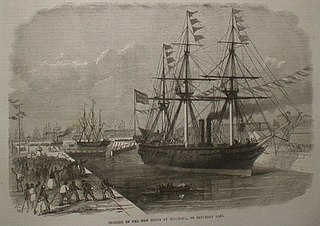
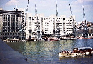
Between 1895 and 1904 Greenland Dock was greatly extended to the west at a cost of £940,000, in a project carried out under Sir John Wolfe Barry, the engineer who built Tower Bridge. More than doubling in length and nearly doubling in depth, in its final form it covered an area of 22+1⁄2 acres (9.1ha), with a depth of 31 feet (9.4m) and a length of 2,250 feet (690m), which cut straight across the old Grand Surrey Canal. It was also given a large lock, 550 feet (170m) long, 80 feet (24m) wide and 35 feet (11m) deep. This renovation enabled the dock to take large cargo ships and even ocean-going liners. Cunard Line A-class vessels of as much as 14,000 long tons (14,000t), driven by large steam engines and carrying passengers and cargoes in both directions, sailed regularly from Greenland Dock to the St. Lawrence River in Canada. They were considered huge ships for so far upstream and they had to be swung round in the river to enter the lock.
In 1909 the dock, along with all of the other London docks, was amalgamated into the Port of London under the management of the Port of London Authority.
In the same era as the big steamships there were, by contrast, the barques and barquentines of less than a tenth the size that brought timber from Finland: survivors of the age of sail with three or more masts and representatives of the Baltic side of the timber trade. Finland Quay, Swedish Quay, Norway Dock and Russia Dock were some of the names arising from what had been the original part of Rotherhithe's timber trade.
Greenland Dock suffered greatly during World War II, when many of the warehouses were razed by German bombing and the great lock was rendered unusable due to bomb damage. It soon recovered after the war and enjoyed a brief resurgence of prosperity. However, technological changes in the shipping industry soon pushed the dock into a spiral of decline. The deal porters' jobs were abolished from 1958 when timber started to be packaged. Not long afterwards, the shipping industry moved en masse to the system of containerization, which required bulk carriers far too large to be accommodated in the London docks. In 1970, the Surrey Commercial Docks were closed. Greenland Dock was sold to Southwark council.
Redevelopment
The ILEA water sports centre, 1980Greenland Dock, Surrey Quays, circa 1995
The Surrey Docks remained derelict for over a decade, with much of the warehousing demolished and over 90% of the docks filled in. Greenland Dock, which now belonged to the local authority, escaped this fate and in 1981 was handed over to the London Docklands Development Corporation. During this period the Inner London Education Authority ran a Surrey Docks Watersports Centre on the dock from a series of portable cabins at the Redriff Road end of the dock. It was at this centre many young people who would not have been exposed to sailing or canoeing were trained.
A masterplan was produced that advocated evicting the remaining industrial occupiers of the quaysides and transforming the dock into a residential area. This went ahead in the late 1980s despite some controversy, with seven residential developments being constructed on the site of the former warehouse complexes (and named after them; hence Swedish Yard became Swedish Quay, Brunswick Yard became Brunswick Quay, Baltic Yard became Baltic Quay and so on). Today the area is dominated by luxury residential developments, such as the Greenland Passage development and the gatedNew Caledonian Wharf. Additionally, a new watersports centre was constructed on the site of the former entrance to the now infilled Grand Surrey Canal. This has maintained the dock as a popular site for sailing, windsurfing, canoeing and dragon boat racing.
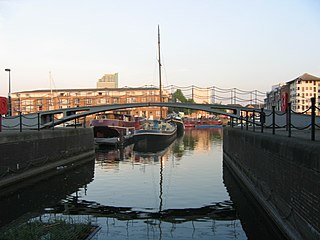
The dock itself is still substantially intact, other than its former entrances and exits, all but one of which have been filled in or blocked. It still has a working connection to South Dock, which is now a marina, and it has a small marina of its own at its eastern end. There are no traces of the former warehouses, although many of the old capstans and some of the hydraulic machines on the quayside have been preserved.
The alternative comedian Malcolm Hardee drowned in the dock in 2005 while stepping onto his houseboat, Sea Sovereign, from the floating pub he owned, the Wibbley Wobbley, which was moored at the Thames end of Greenland Dock.
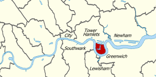
London Docklands is the riverfront and former docks in London. It is located in inner east and southeast London, in the boroughs of Southwark, Tower Hamlets, Lewisham, Newham, and Greenwich. The docks were formerly part of the Port of London, at one time the world's largest port. After the docks closed, the area had become derelict and poverty-ridden by the 1980s. The Docklands' regeneration began later that decade; it has been redeveloped principally for commercial and residential use. The name "London Docklands" was used for the first time in a government report on redevelopment plans in 1971 and has since been almost universally adopted. The redevelopment created wealth, but also led to some conflict between the new and old communities in the area.
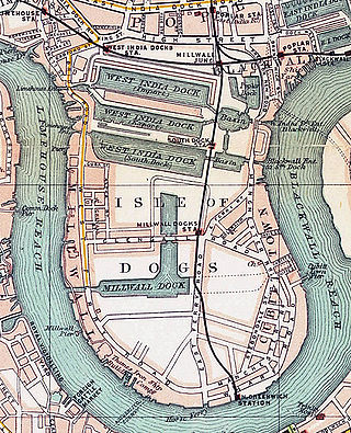
The Isle of Dogs is a large peninsula bounded on three sides by a large meander in the River Thames in East London, England, which includes the Cubitt Town, Millwall and Canary Wharf districts. The area was historically part of the Manor, Hamlet, Parish and, for a time, the wider borough of Poplar. The name had no official status until the 1987 creation of the Isle of Dogs Neighbourhood by Tower Hamlets London Borough Council. It has been known locally as simply "the Island" since the 19th century.
Rotherhithe is a district of south-east London, England, and part of the London Borough of Southwark. It is on a peninsula on the south bank of the Thames, facing Wapping, Shadwell and Limehouse on the north bank, with the Isle of Dogs to the east. It borders Bermondsey to the west and Deptford to the south-east. The district is a part of the Docklands area.
The Port of London is that part of the River Thames in England lying between Teddington Lock and the defined boundary with the North Sea and including any associated docks. Once the largest port in the world, it was the United Kingdom's largest port as of 2020. Usage is largely governed by the Port of London Authority ("PLA"), a public trust established in 1908; while mainly responsible for coordination and enforcement of activities it also has some minor operations of its own.
St Katharine Docks is a former dock and now a mixed-used district in Central London, in the London Borough of Tower Hamlets and within the East End. It lies on the north bank of the River Thames, immediately downstream of the Tower of London and Tower Bridge. From 1828 to 1968, it was one of the commercial docks that made up the Port of London. It is in the redevelopment zone known as Docklands and is now a popular housing and leisure complex.
The West India Docks are a series of three docks, quaysides and warehouses built to import goods from and export goods and occasionally passengers to the British West Indies on the Isle of Dogs in London the first of which opened in 1802. Following their commercial closure in 1980, the Canary Wharf development was built around the wet docks by narrowing some of their broadest tracts.
The Surrey Commercial Docks were a large group of docks in Rotherhithe, South East London, located on the south bank of the River Thames.
Limehouse Basin is a body of water 2 miles east of London Bridge that is also a navigable link between the River Thames and two of London's canals. First dug in 1820 as the eastern terminus of the new Regent's Canal, its wet area was less than 5 acres originally, but it was gradually enlarged in the Victorian era, reaching a maximum of double that size, when it was given its characteristic oblique entrance lock, big enough to admit 2,000-ton ships.
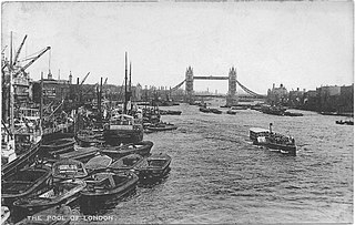
The Pool of London is a stretch of the River Thames from London Bridge to below Limehouse.
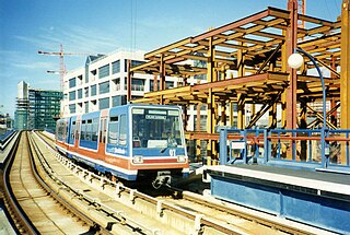
The London Docklands Development Corporation (LDDC) was a quango agency set up by the UK Government in 1981 to regenerate the depressed Docklands area of east London. During its seventeen-year existence it was responsible for regenerating an area of 8.5 square miles (22 km2) in the London Boroughs of Newham, Tower Hamlets and Southwark. LDDC helped to create Canary Wharf, Surrey Quays shopping centre, London City Airport, ExCeL Exhibition Centre, London Arena and the Docklands Light Railway, bringing more than 120,000 new jobs to the Docklands and making the area highly sought after for housing. Although initially fiercely resisted by local councils and residents, today it is generally regarded as having been a success and is now used as an exemplar of large-scale regeneration, although tensions between older and more recent residents remain.
Surrey Docks is a largely residential area of Rotherhithe in south-east London, occupied until 1970 by the Surrey Commercial Docks. The precise boundaries of the area are somewhat amorphous, but it is generally considered to comprise the southern half of the Rotherhithe peninsula from Canada Water to South Dock; electorally, Surrey Docks is the eastern half of the peninsula. The area is served by Surrey Quays railway station on the London Overground route. Surrey Docks are so called because the borders of Surrey and Kent met in this area until 1989.
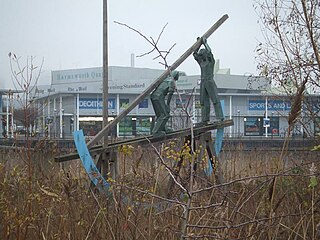
The deal porters were a specialist group of workers in London's docks. They handled baulks of softwood or "deal", stacking them up to 60 feet high in quayside warehouses. This was a demanding and dangerous job. It required physical strength, dexterity and a head for heights, to such an extent that they were nicknamed "Blondins" after the famous acrobat, Charles Blondin. Deal porters wore special leather headgear with long "aprons" over their shoulders in order to protect their heads and necks from wooden splinters.
South Dock is one of two surviving docks in the former Surrey Commercial Docks in Rotherhithe, London, England. It was built in 1807–1811 just south of the larger Greenland Dock, to which it is connected by a channel now known as Greenland Cut; it also has a lock giving access to the River Thames. Originally named the East Country Dock, it was renamed in 1850 when the Surrey Commercial Dock Company purchased and enlarged it. Timber and grain were the main products imported and exported in the dock.
Canada Water is an area of the Docklands in south-east London. It is named after a freshwater lake and wildlife refuge. Canada Water tube, Overground and bus station is immediately north of the lake, along with Canada Water Library which overhangs the lake and Deal Porter Square. Surrey Quays Shopping Centre is also adjacent, sitting immediately to the south. The surrounding area, which forms the town centre of Rotherhithe, is now increasingly known as Canada Water, after the transport interchange as much as the lake itself.
Millwall Dock is a dock at Millwall, London, England, located south of Canary Wharf on the Isle of Dogs.
The Grand Surrey Canal was a canal constructed in south London, England during the early 19th century. It opened to the Old Kent Road in 1807, to Camberwell in 1810, and to Peckham in 1826. Its main purpose was to transport cargo, primarily timber from the Surrey Commercial Docks.
Shadwell Basin is a housing and leisure complex built around a disused dock in Wapping, London. The old dock was formerly part of the London Docks, a group of docks built by the London Dock Company at Shadwell and Wapping as part of the wider docks of the Port of London.
Sailing on the River Thames is practised on both the tidal and non-tidal reaches of the river. The highest club upstream is at Oxford. The most popular sailing craft used on the Thames are lasers, GP14s, Wayfarers and Enterprises. One sailing boat unique to the Thames is the Thames Rater, which is sailed around Raven's Ait.
Odessa Wharf is an early 19th-century warehouse located on the south bank of the River Thames at Rotherhithe, London. The warehouse has been converted into apartments and townhouses, some of which are operated as holiday lets by Odessa Club Management with the remainder as private residences. It is situated directly on the Thames Path national trail, north of Greenland Dock, with distinctive timber box "lanterns" on its roof.
Fresh Wharf was a wharf located in the City of London close to London Bridge, on the north bank of the River Thames. The site was used as a quay in Roman times and later as an unloading place for Anglo-Saxon boats. A wharf was constructed there at some point in the medieval period and appears to have acquired its name from its customary usage as a landing place for fresh fish. In the 16th century, Fresh Wharf was made a "Legal Quay" authorised for the import of certain goods during the reign of Queen Elizabeth I of England. It expanded as London's river-borne trade grew in the 18th and 19th centuries, with large warehouses being established immediately behind the wharf. In the 20th century, the wharf's owners took over the adjoining wharves immediately upstream and downstream, built a new ten-storey warehouse and renamed the site New Fresh Wharf. By the end of the 1960s, however, London's docks had fallen into disuse with the advent of containerization, for which they were not suited, and the wharf was closed down in 1970. An office block was built on the site of the warehouse in 1977 and the former quayside is now part of a public footpath along the Thames.
This page is based on this Wikipedia article Text is available under the CC BY-SA 4.0 license; additional terms may apply. Images, videos and audio are available under their respective licenses.