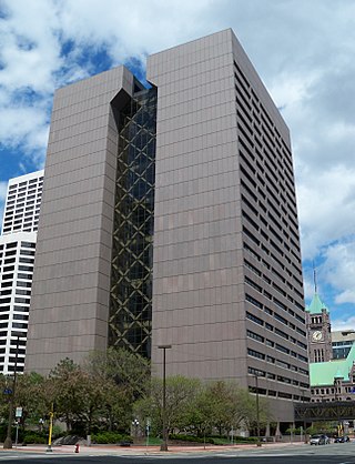
Hennepin County is a county in the U.S. state of Minnesota. Its county seat is Minneapolis, the state's most populous city. The county is named in honor of the 17th-century explorer Father Louis Hennepin. The county extends from Minneapolis to the suburbs and outlying cities in the western part of the county. The county's natural areas are covered with extensive woods, hills, and lakes.

The Eads Bridge is a combined road and railway bridge over the Mississippi River connecting the cities of St. Louis, Missouri, and East St. Louis, Illinois. It is located on the St. Louis riverfront between Laclede's Landing to the north, and the grounds of the Gateway Arch to the south. The bridge is named for its designer and builder, James Buchanan Eads. Work on the bridge began in 1867, and it was completed in 1874. The Eads Bridge was the first bridge across the Mississippi south of the Missouri River. Earlier bridges were located north of the Missouri, where the Mississippi is smaller. None of the earlier bridges survive, which means that the Eads Bridge is also the oldest bridge on the river.

The Stone Arch Bridge is a former railroad bridge crossing the Mississippi River at Saint Anthony Falls in downtown Minneapolis, Minnesota. It is the only arched bridge made of stone on the entire Mississippi River. It is the second oldest bridge on the river next to Eads Bridge. The bridge was built to connect the railway system to the new Union Depot, which at that time was planned to be built between Hennepin Avenue and Nicollet Avenue. The bridge was completed in 1883, costing $650,000 at the time. 117 Portland Avenue is the general address of the historic complex.

Minnesota State Highway 36 (MN 36) is a 21.718-mile-long (34.952 km) highway in Minnesota, which runs from its interchange with Interstate 35W in Roseville and continues east to its eastern terminus at the Wisconsin state line, where it becomes Wisconsin Highway 64 upon crossing the St. Croix River at the St. Croix Crossing bridge. A portion of Highway 36 is a major freeway in suburban Minneapolis – Saint Paul.

The Third Avenue Bridge is a landmark structure of the city of Minneapolis, Minnesota, United States, originally known as the St. Anthony Falls Bridge. It carries road traffic across the Mississippi River and upper fringes of Saint Anthony Falls. The multi-arched bridge meets with Third Avenue in downtown Minneapolis at its south end, but curves as it crosses the river, and connects with Central Avenue on its north end. The shallow "S" curve in the bridge was built to avoid fractures in the limestone bedrock that supports the bridge piers. The road is also designated Minnesota State Highway 65. Construction began in 1914, and it opened four years later in 1918. The bridge, which uses Melan arches of an open spandrel design, has been modified since that time. The 2,223-foot crossing was designed by city engineer Frederick W. Cappelen, who also created plans for other similar bridges in Minneapolis such as the Franklin Avenue Bridge. It cost US$862,254.00 at the time of construction.

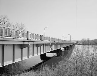
The Washington Avenue Bridge carries County Road 122 and the METRO Green Line light rail across the Mississippi River in Minneapolis and connects the East Bank and West Bank portions of the University of Minnesota campus. The bridge has two decks, with the lower deck designated for motor vehicle traffic and light rail trains and the upper deck used for pedestrians and bicycles. It is a utilitarian structure with simple architecture, but it has cultural significance because thousands of students, faculty, staff, and visitors walk across it every day.

The 10th Avenue Bridge crosses the Mississippi River near downtown Minneapolis, Minnesota and also in proximity to the University of Minnesota. The bridge historically was called the Cedar Avenue Bridge from days prior to the construction of the I-35W bridge when it connected to Cedar Ave. The bridge connects 10th Avenue Southeast, on the east side of the Mississippi River to 19th Avenue South, on the west side. The Seven Corners area of the Cedar-Riverside, Minneapolis neighborhood is at the south end of the bridge. The downstream end of the lower Saint Anthony Falls lock and dam extends under the bridge. The historic Southeast Steam Plant is also nearby.
The North Channel Bridge crosses the north channel of the Mississippi River between Latsch Island and Buffalo County, Wisconsin.

The Smith Avenue High Bridge or the High Bridge is an inverted arch bridge that carries Minnesota State Highway 149 and Smith Avenue over the Mississippi River in Saint Paul, Minnesota, United States. It was built and opened in 1987 at a cost of $20 million. The bridge carries two lanes of street traffic over the river and is the highest bridge in St. Paul, with a deck height of 160 ft (49 m) and a clearance below of 149 ft (45 m).

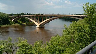
The Intercity Bridge, more commonly known as the Ford Parkway Bridge, is a reinforced concrete arch bridge that spans the Mississippi River between Minneapolis, Minnesota and St. Paul, Minnesota, United States. It connects 46th Street in Minneapolis with Ford Parkway in Saint Paul. The bridge is historically significant as one of the largest reinforced concrete bridges ever built in Minnesota. It was built in 1925-1927 by James O. Heyworth, Inc. and was designed by Martin Sigvart Grytbak. The Intercity Bridge was listed on the National Register of Historic Places in 1989. It is notable as one of the monumental concrete rib-arch bridges spanning the high river bluffs along the Mississippi River, along with the Franklin Avenue Bridge, the Third Avenue Bridge, the 10th Avenue Bridge, and the Robert Street Bridge.
The Lake Street–Marshall Avenue Bridge is a reinforced concrete arch bridge that spans the Mississippi River between Minneapolis, Minnesota and St. Paul, Minnesota. It is oriented east-west and connects Lake Street in Minneapolis to Marshall Avenue in St. Paul. St. Paul residents often refer to it as the Marshall Avenue Bridge. The bridge was designed by Howard, Needles, Tammen, and Bergendoff.

The Hastings High Bridge was a continuous steel through truss bridge that spanned the Mississippi River in Hastings, Minnesota, United States. It was designed by Sverdrup and Parcel and was built in 1951 by Graus Construction Company of Hasting for $356,000. It was demolished in late 2013 when the current Hastings Bridge opened. It had been scheduled to be torn down and replaced by MNDot in 2019, but after the I-35W bridge collapse in Minneapolis, it was re-prioritized and construction started in 2010.

The Anoka–Champlin Mississippi River Bridge, also known as the Ferry Street Bridge, is a 10-span open spandrel concrete deck arch bridge that spans the Mississippi River between Anoka and Champlin, Minnesota, United States. It was built in 1929 by the Minneapolis Bridge Company, replacing an 1884 bridge at the same site.

Broadway Avenue Bridge is a girder bridge that spans the Mississippi River in Minneapolis, Minnesota. Designed by Norman C. Davis and Shawn Pierson Bruns of Van Doren-Hazard-Stallings, it was built in 1987. The bridge has a rather streamlined shape, but its piers are more ornate. The piers have two flat columns that taper together, with a base that extends out to the full width of the bridge.

The I-35W Mississippi River bridge was an eight-lane, steel truss arch bridge that carried Interstate 35W across the Mississippi River one-half mile downstream from the Saint Anthony Falls in Minneapolis, Minnesota, United States. The bridge opened in 1967 and was Minnesota's third busiest, carrying 140,000 vehicles daily. It experienced a catastrophic failure during the evening rush hour on August 1, 2007, killing 13 people and injuring 145. The NTSB cited a design flaw as the likely cause of the collapse, noting that an excessively thin gusset plate ripped along a line of rivets, and that additional weight on the bridge at the time contributed to the catastrophic failure.

The Minneapolis Great Northern Depot, also known as Great Northern Station, was a passenger railroad station which served Minneapolis, Minnesota, USA. It was built in 1913 and demolished in 1978. It was located on Hennepin Avenue next to the Hennepin Avenue Bridge and across the street from the main Minneapolis Post Office.

The following are all the contributing resources to the Saint Anthony Falls Historic District in Minneapolis, Minnesota, United States. The District is listed on the National Register of Historic Places, thus these properties are on the NRHP. The "period of significance" of the District was 1858–1941. The district's archaeological record is considered to be one of the most-endangered historic sites in Minnesota.

Hennepin County Road 122 (CR 122) or County State-Aid Highway 122 (CSAH 122) is an unsigned county state-aid highway within the city of Minneapolis, Hennepin County, Minnesota, United States, crossing the Mississippi River on the Washington Avenue Bridge.

The Dodd Ford Bridge is a bridge spanning the Blue Earth River about 1 mile (2 km) southwest of Amboy, Minnesota, in Blue Earth County, Minnesota.


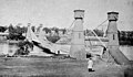 The original structure circa 1865
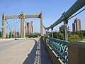 Facing Northeast Minneapolis
 Bridge with Grain Belt sign (inset)
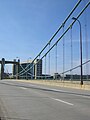 Facing the Federal Reserve Bank of Minneapolis


