The IJkdijk is a facility in the Netherlands to test dikes and to develop sensor network technologies for early warning systems. Furthermore, the sensor network will be able to detect many water-related environmental factors that affect the health of humans such as pollution and biological changes. Disasters on rivers and coastal waters are also detected.
In studies of dike stability, about eighty dikes will be destroyed and establish, ultimately, a relation between the sensor readings and the future of the dike. Hence the (in Dutch) good-sounding name IJkdijk: dijk=dike and ijk is from the Dutch word ijken=to calibrate (models). Clearly the most urgent goal here is to forecast dike failures. In contrast to popular belief, most disasters with dikes occur because they are too wet and not because they are too low. Another major source of dike failures are streams of water flowing through the dike, ultimately destroying, through erosion, the dike from the inside. A detection system for these failure mechanisms might be cheaper and safer than the alternative: over-dimensioning by adding more clay. As dike improvements are very costly, e.g. 500 euros per meter, there is ample financial room to pay for the sensor system. The IJkdijk will also increase the geophysical understanding of dike behavior. A better understanding of dikes, expressed in a sensor-based early warning system in dikes, prevents unnecessary and costly over-dimensioning. That is good news for the owners of millions of kilometers of dikes that exist nowadays and the developers of millions of kilometers of dikes that will be constructed in the future.
Driving forces
Failed section of peat levee at Wilnis, August 2003
Dike innovations are no luxury. With the expected climate changes, the land subsidence, the increased economic value of the low-lying areas as a result of economic prosperity, and the declining acceptance of calamities by the general public, many countries of world need to invest substantially in flood protection to keep the risk of flooding at an acceptable level. Especially developing countries seek new lands for housing and industry which are frequently found close(r) to rivers. Here building dikes is equivalent to economic growth. As investments in dikes are in the same order of magnitude as investments in economic development, developing countries will benefit most from smarter, cheaper and safer dikes.
Developments in communication and sensor technology have advanced so far that it seems possible to utilize this new technology to effectively support the management and monitoring of flood protection works in an economically efficient manner. This seems to open up ways to offer cheaper and better alternatives for the traditional methods of embankment monitoring, maintenance and improvement. However, most of the recently developed sensor technology still needs to be tested under field circumstances, to prove its applicability and suitability. Recently, prototypes of dike conditioning systems have been constructed that aim at maintaining the dikes continuously in optimum shape. Inline with jargon from the sensor communities we call such systems actuators.
Design goals
River embankment at Bergambacht after field test, November 2001
In many cases, protection against flooding is not only determined by the height of the embankments, but merely by the strength of the embankments. Most of the weak spots in the embankments collapse because of a lack of strength with regard to stability or internal erosion rather than be flooded. The key to a better utilization of the existing embankments and thereby reduction of the flood risks is to find ways to determine the very processes which undermine the strength of embankments with a high degree of certainty. The system must ultimately be able to sense weaknesses in tens of thousands of kilometers of embankments.
Determining failure processes of embankments is still a research field in development. It is clear that the strength of embankments depends on a large number of parameters which are hard to determine. Calculation methods for embankment strengths are available, but there seems to be a significant uncertainty, or gap, between the calculated strengths and the actual ones. Because of the huge investments involved and the increasing costs of maintenance and management for the regional water boards this is a very unsatisfactory situation. Systematic experiments are needed to calibrate the models. This enables the design of correctly sized embankments. Furthermore, a primary design goal are models, when fed by real time data from sensors in dikes, calculate the short and long time future of the embankment system. Most importantly they can report if immediate safety issues are at stake.
IJkdijk consortium
The IJkdijk (‘Calibration dike’ (or embankment, levee)) is an initiative of the research institutes TNO ICT and Deltares[nl], the Dutch national water board research foundation STOWA (Stichting Toegepast Onderzoek Waterschappen), regional development agencies NOM (Investerings- en Ontwikkelingsmaatschappij voor Noord-Nederland) and IDL. The plan emerged to build test embankments to enable the systematic testing of various types of new sensor, actuator and communication technologies, both during construction and the entire lifetime of an embankment. The embankments and the corresponding data infrastructure are set up in such a way that ensures that any future technologies can be tested. Furthermore, the IJkdijk is an open innovation environment where companies have been invited to join the experiments. About 50 companies are enlisted now.
IJkdijk results
The IJkdijk enables to overstress embankments to failure using diverse and realistic methods in a controlled and reproducible manner. This will provide knowledge of:
sensor, actuator and communication technology for embankment monitoring;
enhanced geophysical knowledge of failure mechanisms and computer models that forecast these failure mechanisms;
the practical and economical feasibility of systems tested for use in large-scale applications;
technologies for large scale sensor, actuator and communication technology that support GEOSS technologies;
Thus, the IJkdijk project provides valuable insights and practical technologies for organizations dealing with water management, e.g. regional water boards and the national department of public works – everywhere in the world.
New technologies
Several new (sensor) technologies may contribute to a more accurate, cheaper and/or faster determination of the relevant parameters in the various processes which may lead to embankment failure, resulting in a better picture of the actual strength and the current protection level of the embankment and enabling measures in a more timely and location-specific manner. This is of great importance. Intensive monitoring of the strength:
reduces costly over-dimensioning of embankment reinforcements, or the alternative, widening and deepening of the river system;
enables transparent and reproducible decision-making during imminent calamities;
enables improved determination of the effectiveness of innovative reinforcement technologies;
increases the accuracy of the results of periodical safety assessments of embankments, such as the five-yearly safety assessment in the Netherlands enforced by the Dutch law, providing a continuously up-to-date picture of the actual safety situation;
may contribute to establish the priorities and effectiveness of measures such as the river realignment works currently in preparation for the Lower Rhine river system in the Netherlands.
There is a growing need for new methods to measure the various key parameters related to embankment safety. But solutions exist, while new solutions are under development.
Testing new technologies
Although there is a growing need for a more continuous and objective manner of measuring and monitoring, at the same time there is too little knowledge to evaluate the favourability of current technologies. There are a number of reasons for this:
There are no generally accepted selection criteria for applying a specific technology;
Most available technologies may have a proven track record in laboratory conditions or in fields different from those in which the regional water boards operate, but they have no track record in real field situations relevant to the water boards;
Often, there is insufficient clarity for the district water boards about the profitability of the different technologies and systems in practice: what will this investment yield?
There is general need among the regional water boards, but the actual need has not yet crystallized.
In view of the gap between the suppliers for embankment technologies on the one hand, and the regional water boards with their questions on the other hand, the test facility of IJkdijk is being set up. The fieldlab shows and evaluates technologies for an audience of water management bodies. Furthermore, the new insights in the geophysical processes of dikes and their monitor systems can be translated to well-considered actions, embankment designs and accurate maintenance planning.
Sensor technology in and around embankments to forecast future failures
Project objectives
The first IJkdijk, built in December 2006, destroyed by wave overtopping experiments in November 2007. It is 14 meters long, 4 meters high and wide
The objectives of the IJkdijk project are:
To study the applicability of sensor technologies in controlled field situations for the inspection and monitoring of flood defences as performed by the water boards;
To develop know-how on the development of embankment failure mechanisms with the use of applicable sensor technologies to develop a warning system for embankments, levees and dams;
To use sensor technologies to investigate the current state of embankments in greatest detail over thousands of kilometers.
To stimulate the business prospects of those companies who are involved with the project.
The commercial parties will focus on development of the technologies, while the research institutions will concentrate on development of knowledge. The failure mechanisms which are to be monitored will be central in the project.
In a brainstorm session with several experts from regional water boards, the department of public works and the inspecting authorities, the following questions have been formulated from the point of view of the water management bodies:
What processes occur within embankments and what are their effects on potential failure mechanisms?
What are the indicative parameters and what is the relation between these parameters and the occurrence of a failure mechanism?
Which decisive actions can be distinguished when a calamity is imminent?
Which technologies are suitable to measure the indicative parameters in existing embankments? How to choose from the technologies offered? What should be the spatial intensity and the frequency of the measurements?
What are the costs and benefits for the implementation of new monitoring technologies?
In the initial phase of the project these questions will be addressed and converted into experiments to be conducted.
Technical facilities
The first dike at the opening of the IJkdijk facility on November 2, 2007. The yellow construction is a wave over topping simulator that is able to flood the land side of a dike with 14m waves.
The IJkdijk provides an infrastructure for to connect various sensor and actuator systems. It supplies them with energy and fixed and wireless communication means. Furthermore, a camera system and weather monitor is present to augment any other observations.
The infrastructure is developed in several phases, allowing flexibility and, above all, the possibility to learn and improve. Initially, only the infrastructure to conduct the first experiments and the reference measurements will be implemented, and the network infrastructure required for the connection of the sensors for subsequent experiments. The following are considered:
An application platform with a number of basic applications (GIS visualization, command and control facilities, ...);
A multiparty data acquisition, data publishing and analysis infrastructure;
A regular network for the permanent sensors;
The permanent sensors;
Access points to the network for the experiment-specific sensors. These will be based on both cable and wireless network technology;
A power source.
Over time, the infrastructure will grow based on the demands and requirements of the experiments to be conducted. The next figure shows a plan view of the location with the spatial planning of the larger elements planned so far.
Experiments
A movie that shows the last wave thrown over a dike at the opening of the IJkdijk facility on November 2, 2007
The intention is to study systematically a wide range of geophysical processes in embankments. At first, a series of experiments is conducted in which previously applied technologies such as CTD divers, flux meters and humidity meters are used. These will be read continuously via remote (wireless) network monitoring. As stated in the table above, experiments are always combinations of a failure mechanism to be studied, a loading scheme, and several measuring methods. At present, experiments are in preparation related to stability, erosion due to wave over-topping, sliding due to steady state overflow and internal erosion (piping).
Apart from experiments to increase the knowledge of failure mechanisms, there will also be experiments that aim more specifically at testing new sensor technologies and their relevance to flood defence management. Together, both types of experiments will contribute substantially to the effectiveness and efficiency of embankments both in the Netherlands and abroad.
A gaping hole was created by the wave over topping experiment on November 2, 2007.
The Macrostability Experiment
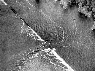
The dike that collapsed on Saturday September the 27th at 16.02h was part of an experiment that gathered data about the stability of dikes. Furthermore, several sensor systems were tested in the experiment. More than a terabyte of data was obtained, a globally unique data set. The experiment was the first scientific success of the IJkdijk.
The dike was roughly 100m long, 30m wide and 6m high and consisted of a nucleus of white sand and a shell of clay. A drainage system was placed at the bottom of the sand nucleus, allowing the addition or removal of water. Containers were placed on top of the dike, eventually to be filled with water. The subsoil was charted carefully, whilst the dike contained numerous proven and experimental sensor systems. In addition to that, the dike was carefully monitored from the outside by lidar and visual and infrared camera systems, and, of course, numerous people. When the dike was completed, on Friday September 26, a ditch was cut in the soil and subsoil. After 16 hours, at 08.00h on Saturday 27 of September 2008, the waterlevel in the dike was raised. At 16.02h, the dike collapsed.
The dike built and destroyed in the Macrostability Experiment that was conducted in September 2008
A levee, dike, dyke, embankment, floodbank or stopbank is an elongated naturally occurring ridge or artificially constructed fill or wall, which regulates water levels. It is usually earthen and often parallel to the course of a river in its floodplain or along low-lying coastlines.
Telemetry is the collection of measurements or other data at remote or inaccessible points and their automatic transmission to receiving equipment for monitoring. The word is derived from Greek the roots tele, "remote", and metron, "measure". Systems that need external instructions and data to operate require the counterpart of telemetry, telecommand.
Instrumentation is a collective term for measuring instruments that are used for indicating, measuring and recording physical quantities such as flow, temperature, level, distance, angle, or pressure. The term has its origins in the art and science of scientific instrument-making.
A dam is a barrier that stops or restricts the flow of water or underground streams. Reservoirs created by dams not only suppress floods but also provide water for activities such as irrigation, human consumption, industrial use, aquaculture, and navigability. Hydropower is often used in conjunction with dams to generate electricity. A dam can also be used to collect water or for storage of water which can be evenly distributed between locations. Dams generally serve the primary purpose of retaining water, while other structures such as floodgates or levees are used to manage or prevent water flow into specific land regions. The earliest known dam is the Jawa Dam in Jordan, dating to 3,000 BC.
Wireless sensor network (WSN) refers to a group of spatially dispersed and dedicated sensors for monitoring and recording the physical conditions of the environment and organizing the collected data at a central location. WSNs measure environmental conditions like temperature, sound, pollution levels, humidity, wind, and so on.
A levee breach or levee failure is a situation where a levee fails or is intentionally breached, causing the previously contained water to flood the land behind the levee.
SensorML is an approved Open Geospatial Consortium standard. SensorML provides standard models and an XML encoding for describing sensors and measurement processes. SensorML can be used to describe a wide range of sensors, including both dynamic and stationary platforms and both in-situ and remote sensors.
Flood control is an important issue for the Netherlands, as due to its low elevation, approximately two thirds of its area is vulnerable to flooding, while the country is densely populated. Natural sand dunes and constructed dikes, dams, and floodgates provide defense against storm surges from the sea. River dikes prevent flooding from water flowing into the country by the major rivers Rhine and Meuse, while a complicated system of drainage ditches, canals, and pumping stations keep the low-lying parts dry for habitation and agriculture. Water control boards are the independent local government bodies responsible for maintaining this system.
In the automotive industry, brake-by-wire technology is the ability to control brakes through electrical means. It can be designed to supplement ordinary service brakes or it can be a standalone brake system.
The following are considered essential ocean climate variables by the Ocean Observations Panel for Climate (OOPC) that are currently feasible with current observational systems.
The Semantic Sensor Web (SSW) is a marriage of sensor and Semantic Web technologies. The encoding of sensor descriptions and sensor observation data with Semantic Web languages enables more expressive representation, advanced access, and formal analysis of sensor resources. The SSW annotates sensor data with spatial, temporal, and thematic semantic metadata. This technique builds on current standardization efforts within the Open Geospatial Consortium's Sensor Web Enablement (SWE) and extends them with Semantic Web technologies to provide enhanced descriptions and access to sensor data.
The Lviv Centre of the Space Research Institute of the NASU and NSAU is a Lviv branch of the actual institute.
Vflo is a commercially available, physics-based distributed hydrologic model generated by Vieux & Associates, Inc. Vflo uses radar rainfall data for hydrologic input to simulate distributed runoff. Vflo employs GIS maps for parameterization via a desktop interface. The model is suited for distributed hydrologic forecasting in post-analysis and in continuous operations. Vflo output is in the form of hydrographs at selected drainage network grids, as well as distributed runoff maps covering the watershed. Model applications include civil infrastructure operations and maintenance, stormwater prediction and emergency management, continuous and short-term surface water runoff, recharge estimation, soil moisture monitoring, land use planning, water quality monitoring, and water resources management.
OptiY is a design environment providing modern optimization strategies and state of the art probabilistic algorithms for uncertainty, reliability, robustness, sensitivity analysis, data-mining and meta-modeling.
In medicine, monitoring is the observation of a disease, condition or one or several medical parameters over time.
Remote patient monitoring (RPM) is a technology to enable monitoring of patients outside of conventional clinical settings, such as in the home or in a remote area, which may increase access to care and decrease healthcare delivery costs.
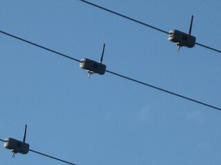
A Wireless powerline sensor hangs from an overhead power line and sends measurements to a data collection system. Because the sensor does not contact anything but a single live conductor, no high-voltage isolation is needed. The sensor, installed simply by clamping it around a conductor, powers itself from energy scavenged from electrical or magnetic fields surrounding the conductor being measured. Overhead power line monitoring helps distribution system operators provide reliable service at optimized cost.
A fixed-point ocean observatory is an autonomous system of automatic sensors and samplers that continuously gathers data from deep sea, water column and lower atmosphere, and transmits the data to shore in real or near real-time.
Nimbus 4 was a meteorological satellite. It was the fourth in a series of the Nimbus program.
This page is based on this Wikipedia article Text is available under the CC BY-SA 4.0 license; additional terms may apply. Images, videos and audio are available under their respective licenses.