Illinois's congressional districts

Last updated

Illinois' congressional districts since 2023 Illinois Congressional Districts, 118th Congress.tif
Illinois' congressional districts since 2023

Illinois is divided into 17 congressional districts, each represented by a member of the United States House of Representatives. The majority of Illinois' districts are located in the Chicago area.

Contents

The Illinois General Assembly has the primary responsibility of redrawing congressional district lines following each decennial census. The governor of Illinois has the power to veto proposed congressional district maps, but the General Assembly has the power to override the veto with the support of 3/5ths of both chambers. In 1971, 1981, and 1991 the General Assembly was unable to come to an agreement, and the map was drawn up by a panel of three federal judges chosen by Democrats and Republicans. [1] [2]

In 2001, the General Assembly was again unable to reach an agreement, and the task of redrawing district boundaries was given to the Illinois congressional delegation. With unified Democratic control of the General Assembly and governor's office during the 2011 and 2021 redistricting cycles, Democrats have been able to redistrict without input from Republicans leading to districts gerrymandered to favor the Democratic Party. [2] [3]

In the 2022 midterm elections, per the 2020 United States census, Illinois lost a congressional seat. [4] From a high of 27 congressional seats apportioned to Illinois following the 1910 and 1930 censuses, the state has lost one to two seats in every reapportionment cycle since 1940 with the exception of the cycle following the 1970 census.

Current districts and representatives

List of members of the United States House delegation from Illinois, their terms, district maps, and the district political ratings according to the CPVI. The delegation in the 118th United States Congress has a total of 17 members, with 14 Democrats and 3 Republicans as of 2023.

Current U.S. representatives from Illinois
DistrictMember
(Residence) [5]
PartyIncumbent since CPVI
(2022) [6]
District map
1st Rep. Jonathan Jackson official portrait, 118th Congress.jpg
Jonathan Jackson
(Chicago)
DemocraticJanuary 3, 2023D+20 Illinois's 1st congressional district (since 2023) (new version).svg
2nd Rep. Robin Kelly, 117th Congress.jpg
Robin Kelly
(Matteson)
DemocraticApril 11, 2013D+19 Illinois's 2nd congressional district (since 2023) (new version).svg
3rd Rep. Delia Ramirez official portrait, 118th Congress.jpg
Delia Ramirez
(Chicago)
DemocraticJanuary 3, 2023D+20 Illinois's 3rd congressional district (since 2023) (new version).svg
4th Chuy Garcia official portrait.jpg
Chuy García
(Chicago)
DemocraticJanuary 3, 2019D+22 Illinois's 4th congressional district (since 2023) (new version).svg
5th Mike Quigley official photo (cropped).jpg
Mike Quigley
(Chicago)
DemocraticApril 7, 2009D+18 Illinois's 5th congressional district (since 2023) (new version).svg
6th Sean Casten, official portrait, 116th Congress.jpg
Sean Casten
(Downers Grove)
DemocraticJanuary 3, 2019D+3 Illinois's 6th congressional district (since 2023) (new version).svg
7th DannyKDavis113th (cropped).jpg
Danny Davis
(Chicago)
DemocraticJanuary 3, 1997D+36 Illinois's 7th congressional district (since 2023) (new version).svg
8th Raja Krishnamoorthi official photo.jpg
Raja Krishnamoorthi
(Schaumburg)
DemocraticJanuary 3, 2017D+6 Illinois's 8th congressional district (since 2023) (new version).svg
9th Jan Schakowsky official photo.jpg
Jan Schakowsky
(Evanston)
DemocraticJanuary 3, 1999D+19 Illinois's 9th congressional district (since 2023) (new version).svg
10th Brad Schneider official photo.jpg
Brad Schneider
(Deerfield)
DemocraticJanuary 3, 2017D+11 Illinois's 10th congressional district (since 2023) (new version).svg
11th Bill Foster, Official Portrait, 113th Congress.jpg
Bill Foster
(Naperville)
DemocraticJanuary 3, 2013D+5 Illinois's 11th congressional district (since 2023) (new version).svg
12th Rep. Mike Bost official photo, 117th Congress.jpg
Mike Bost
(Murphysboro)
RepublicanJanuary 3, 2015R+24 Illinois's 12th congressional district (since 2023) (new version).svg
13th Rep. Nikki Budzinski official portrait, 118th Congress.jpg
Nikki Budzinski
(Springfield)
DemocraticJanuary 3, 2023D+3 Illinois's 13th congressional district (since 2023) (new version).svg
14th Lauren Underwood official portrait (cropped).jpg
Lauren Underwood
(Naperville)
DemocraticJanuary 3, 2019D+4 Illinois's 14th congressional district (since 2023) (new version).svg
15th Mary Miller 117th U.S Congress.jpg
Mary Miller
(Oakland)
RepublicanJanuary 3, 2021R+22 Illinois's 15th congressional district (since 2023) (new version).svg
16th Darin LaHood official photo.jpg
Darin LaHood
(Peoria)
RepublicanSeptember 10, 2015R+13 Illinois's 16th congressional district (since 2023) (new version).svg
17th Sorensen House Photo.jpg
Eric Sorensen
(Moline)
DemocraticJanuary 3, 2023D+2 Illinois's 17th congressional district (since 2023) (new version).svg

Historical and present district boundaries

Table of United States congressional district boundary maps in the State of Illinois, presented chronologically. [7] All redistricting events that took place in Illinois from statehood in 1818 to 2013 are shown. During the periods of 1863-1873, 1893-1895, and 1903-1948, voters in Illinois elected an additional one to two at-large representatives.

YearStatewide mapChicago highlight
1818-1833From 1818-1833 Illinois was represented by a single at-large member of Congress.
1833-1843 Statewide boundaries for United States congressional districts in Illinois, 1833-1843.png
1843-1853 United States Congressional Districts in Illinois, 1843-1853.png
1853-1863 United States Congressional Districts in Illinois, 1853-1863.png
1863-1873 United States Congressional Districts in Illinois, 1863-1873.png
1873-1883 United States Congressional Districts in Illinois, 1873-1883.png United States Congressional Districts in Illinois (Chicago), 1873-1883.png
1883-1895 United States Congressional Districts in Illinois, 1883-1895.png United States Congressional Districts in Illinois (Chicago), 1883-1895.png
1895-1903 United States Congressional Districts in Illinois, 1895-1903.png United States Congressional Districts in Illinois (Chicago), 1895-1903.png
1903-1948 Statewide boundaries for United States congressional districts in Illinois, 1943-1948.png
United States Congressional Districts in Illinois (Chicago), 1943-1948.png
1949-1952 United States Congressional Districts in Illinois, 1949-1952.png
United States Congressional Districts in Illinois (Chicago), 1949-1952.png
1953-1962 United States Congressional Districts in Illinois, 1953-1962.png
United States Congressional Districts in Illinois (Chicago), 1953-1962.png
1963-1966 United States Congressional Districts in Illinois, 1963-1972.png
United States Congressional Districts in Illinois (Chicago), 1963-1972.png
1967-1972 United States Congressional Districts in Illinois, 1967-1972.png
United States Congressional Districts in Illinois (Chicago), 1967-1972.png
1973–1982 United States Congressional Districts in Illinois, 1973 - 1982.tif United States Congressional Districts in Illinois (metro highlight), 1973 - 1982.tif
1983–1992 United States Congressional Districts in Illinois, 1983 - 1992.tif United States Congressional Districts in Illinois (metro highlight), 1983 - 1992.tif
1993–2002 United States Congressional Districts in Illinois, 1993 - 2002.tif United States Congressional Districts in Illinois (metro highlight), 1993 - 2002.tif
2003–2013 United States Congressional Districts in Illinois, 2003 - 2013.tif United States Congressional Districts in Illinois (metro highlight), 2003 - 2013.tif
2013–2023 United States Congressional Districts in Illinois, since 2013.tif United States Congressional Districts in Illinois (metro highlight), since 2013.tif

Obsolete districts

See also

Related Research Articles

<span class="mw-page-title-main">United States congressional delegations from Texas</span>

These are tables of congressional delegations from the State of Texas to the United States Senate and United States House of Representatives.

<span class="mw-page-title-main">North Carolina's congressional districts</span> U.S. House districts in the state of North Carolina

North Carolina is currently divided into 14 congressional districts, each represented by a member of the United States House of Representatives. After the 2000 census, the number of North Carolina's seats was increased from 12 to 13 due to the state's increase in population. In the 2022 elections, per the 2020 United States census, North Carolina gained one new congressional seat for a total of 14.

<span class="mw-page-title-main">Maryland's 6th congressional district</span> U.S. House district for Maryland

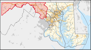
Maryland's 6th congressional district elects a representative to the United States House of Representatives from the northwest part of the state. The district comprises all of Garrett, Allegany, Frederick, and Washington counties as well as a portion of Montgomery County. David Trone (D) is its current representative.

<span class="mw-page-title-main">Tennessee's congressional districts</span>

There are currently nine United States congressional districts in Tennessee based on results from the 2020 United States census. There have been as few as eight and as many as thirteen congressional districts in Tennessee. The 13th district and the 12th district were lost after the 1840 census. The 11th district was lost after the 1850 census and the 10th district was last lost after the 1950 census. The 9th district was briefly lost after the 1970 census but was regained after the 1980 census.

<span class="mw-page-title-main">Kentucky's congressional districts</span>

Kentucky is currently divided into six congressional districts, each represented by a member of the United States House of Representatives. The number of congressional districts has been set at six since the 1990 redistricting cycle.

<span class="mw-page-title-main">Ohio's congressional districts</span> Congressional districts in the U.S. state of Ohio

Ohio is divided into 15 congressional districts, each represented by a member of the United States House of Representatives. After the 2010 census, Ohio lost two House seats due to slow population growth compared to the national average, and a new map was signed into law on September 26, 2011. Starting in the 2022 midterms, per the 2020 United States census, Ohio will lose a congressional seat.

<span class="mw-page-title-main">California's congressional districts</span> U.S. House districts in the state of California

California is the most populous U.S. state; as a result, it has the most representation in the United States House of Representatives, with 52 Representatives. Each Representative represents one congressional district.

<span class="mw-page-title-main">South Carolina's congressional districts</span> U.S. House districts in the state of South Carolina

There are currently seven United States congressional districts in South Carolina. There have been as few as four and as many as nine congressional districts in South Carolina. The 9th district and the 8th district were lost after the 1840 census. The 5th district and the 6th district were also briefly lost after the Civil War, but both had been regained by the 1880 census. Because of the state population growth in the 2010 census, South Carolina regained its 7th district, which had remained unused since the Civil War.

<span class="mw-page-title-main">Pennsylvania's congressional districts</span> Congressional districting since 2003

After the 2000 census, the Commonwealth of Pennsylvania was divided into 19 congressional districts, decreasing from 21 due to reapportionment.

<span class="mw-page-title-main">Florida's congressional districts</span> U.S. House districts in the state of Florida

Florida is divided into 28 congressional districts, each represented by a member of the United States House of Representatives. After the 2020 census, the number of Florida's seats was increased from 27 to 28, due to the state's increase in population, and subsequent reapportionment in 2022.

<span class="mw-page-title-main">Virginia's congressional districts</span> U.S. House districts in the state of Virginia

Virginia is currently divided into 11 congressional districts, each represented by a member of the United States House of Representatives. The death of Rep. Donald McEachin on November 28, 2022, left the 4th congressional district seat empty. Following the results of a special election to fill his seat on February 21, 2023, Jennifer McClellan made history by becoming Virginia's first black congresswoman.

<span class="mw-page-title-main">Illinois's 4th congressional district</span> U.S. House district for Illinois

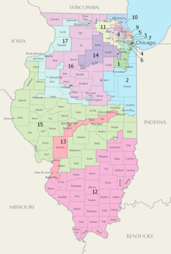
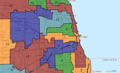
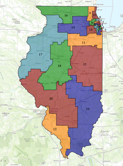
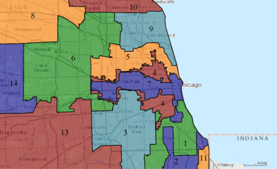
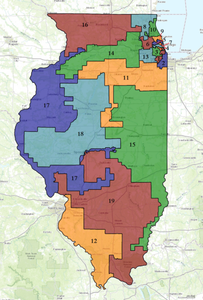
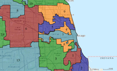
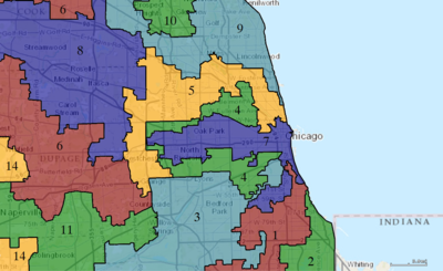
The 4th congressional district of Illinois includes part of Cook County, and has been represented by Democrat Jesús "Chuy" García since January 2019.

<span class="mw-page-title-main">Utah's congressional districts</span>

Utah is divided into 4 congressional districts, each represented by a member of the United States House of Representatives. After the 2010 census, Utah gained one House seat, and a new map was approved by the state legislature and signed into law by Governor Gary Herbert.

<span class="mw-page-title-main">Washington's congressional districts</span> U.S. House districts in the state of Washington

The following is a list of the ten congressional districts in the U.S. state of Washington. From the time that Washington Territory was formed in 1853, through statehood in 1889, Washington Territory elected an at-large non-voting Delegate to the United States House of Representatives. At different times in its history, the state of Washington has also elected one or more representatives At-large statewide. Washington gained its 10th district following reapportionment after the 2010 census.

<span class="mw-page-title-main">Maryland's congressional districts</span> U.S. House districts in the state of Maryland

Maryland is divided into eight congressional districts, each represented by a member of the United States House of Representatives. After the 2020 census, the number of Maryland's seats remained unchanged, giving evidence of stable population growth relative to the United States at large.

<span class="mw-page-title-main">Redistricting in California</span> Redistricting of Californias districts for the U.S. House of Representatives

Redistricting in California has historically been highly controversial. Critics have accused legislators of attempting to protect themselves from competition by gerrymandering districts. Conflicts between the governor and the legislature during redistricting often have only been resolved by the courts.

<span class="mw-page-title-main">2020 United States redistricting cycle</span>

The 2020 United States redistricting cycle is in progress following the completion of the 2020 United States census. In all fifty states, various bodies are re-drawing state legislative districts. States that are apportioned more than one seat in the United States House of Representatives are also drawing new districts for that legislative body.

<span class="mw-page-title-main">Redistricting in North Carolina</span> USA gerrymandering controversy (2010-)

Redistricting in North Carolina has been a controversial topic due to allegations and admissions of gerrymandering.

<span class="mw-page-title-main">Redistricting in Wisconsin</span>

Redistricting in Wisconsin is the process by which boundaries are redrawn for municipal wards, Wisconsin State Assembly districts, Wisconsin State Senate districts, and Wisconsin's congressional districts. Redistricting typically occurs—as in other U.S. states—once every decade, usually in the year after the decennial United States census. According to the Wisconsin Constitution, redistricting in Wisconsin follows the regular legislative process, it must be passed by both houses of the Wisconsin Legislature and signed by the Governor of Wisconsin—unless the Legislature has sufficient votes to override a gubernatorial veto. Due to political gridlock, however, it has become common for Wisconsin redistricting to be conducted by courts. The 1982, 1992, and 2002 legislative maps were each enacted by panels of United States federal judges; the 1964 and 2022 maps were enacted by the Wisconsin Supreme Court.

Smiley v. Holm, 285 U.S. 355 (1932), was a decision of the Supreme Court of the United States involving a governor's power to veto a congressional redistricting proposal passed by a state's legislature. In an opinion by Chief Justice Charles Evans Hughes, the Court unanimously held that the U.S. Constitution did not prohibit Minnesota's governor from vetoing that state's redistricting map.

References

  1. "Illinois". The American Redistricting Project. Retrieved April 18, 2024.
  2. 1 2 "A guide to political redistricting in Illinois". Chicago Tribune. April 19, 2021. Retrieved April 18, 2024.
  3. "Redistricting Report Card". gerrymander.princeton.edu. Retrieved April 18, 2024.
  4. Merica, Dan; Stark, Liz (April 26, 2021). "Census Bureau announces 331 million people in US, Texas will add two congressional seats". CNN. Retrieved April 26, 2021.
  5. "Office of the Clerk, U.S. House of Representatives". clerk.house.gov. Retrieved January 10, 2022.
  6. "2022 Cook PVI: District Map and List". Cook Political Report. Retrieved January 8, 2023.
  7. "Digital Boundary Definitions of United States Congressional Districts, 1789–2012" . Retrieved October 18, 2014.