Flag of Kyrgyzstan - Kyrgyz - Kyrgyzstan - Outline of Kyrgyzstan
Aksy - Balykchy - Chatyr-Kul - Chuy Valley - Climate of Kyrgyzstan - Environmental issues in Kyrgyzstan - Fergana Valley - Issyk-Kul Lake - Kara-Suu District - List of birds of Kyrgyzstan - List of mammals of Kyrgyzstan - Peak Jengish Chokusu- Provinces of Kyrgyzstan - Raions of Kyrgyzstan - Songköl Too - Sulayman Mountain - Tian-Shan
Aksy - Bishkek- Batken - Chuy - Jalal-Abad - List of villages in Kyrgyzstan - Naryn - Osh - Talas
Batken Region - Chuy Region - Issyk Kul Region - Jalal-Abad Region - Naryn Region - Osh Region- Talas Region
Ala-Archa River - Alabuga River - At-Bashi River - Chatkal River - Chong-Kemin River - Chu River - Kara Darya - Kara-Suu - Kegart River - Kichi-Kemin River - Kurshab River - Naryn River - Sokh River - Talas River - Tar River (Kyrgyzstan) - Toshkan River - Vakhsh River - Ysyk-Ata River
Alay Valley- Arpa Valley - Chuy Valley - Fergana Valley - Kichi-Kemin Valley
Yenisei Kyrgyz- Saka - Turkic Kaganate - Uighur Kaganate - Turkic expansion - Mongol invasion of Central Asia - Oirats - Qing Dynasty - Khanate of Kokand - Kara-Kyrgyz Autonomous Oblast - Kirghiz rebellion - Battle of Kashgar (1933) - Battle of Kashgar (1934) - Kirghiz Soviet Socialist Republic - Democratic Movement of Kyrgyzstan - Commonwealth of Independent States - Osh riots (1990) - Tulip Revolution - 2010 Kyrgyzstan crisis - 2010 Kyrgyzstani uprising - 2010 South Kyrgyzstan riots
Demographics of Kyrgyzstan - Kyrgyz language - Kyrgyz alphabet - Old Turkic script - Romanization of Kyrgyz - Turkic peoples
Buddhism in Kyrgyzstan - Christianity in Kyrgyzstan - Islam in Kyrgyzstan - Roman Catholicism in Kyrgyzstan - Jews in Kyrgyzstan
Bride kidnapping - Cuisine of Kyrgyzstan - Foundation for Tolerance International - Komuz - Kyrgyz music - Kyz Kuumai - LGBT rights in Kyrgyzstan (Gay rights) - List of World Heritage Sites in Kyrgyzstan - Epic of Manas - Saimaluu Tash - Tush kyiz - Where the Sky Meets the Land
American University of Central Asia - International Atatürk-Alatoo University -International University Of Kyrgyzstan - Kyrgyz National University - Kyrgyz Technical University - Osh State University - Osh State University
Collective Security Treaty Organisation - Diplomatic missions in Kyrgyzstan - Diplomatic missions of Kyrgyzstan Egemen - Elections in Kyrgyzstan - Kyrgyzstan–Russia relations List of political parties in Kyrgyzstan - People's Movement of Kyrgyzstan
Valentina Shevchenko - Abdylas Maldybaev - Almazbek Atambayev - Askar Akayev - Bermet Akayeva- Chinghiz Aitmatov - Nazira Aytbekova - Daniyar Usenov - Felix Kulov - Kasym Tynystanov - Kurmanbek Bakiyev - Kurmanjan Datka - Omurbek Tekebayev - Orzubek Nazarov - Nasirdin Isanov - Roza Otunbayeva - Zamira Sydykova
Agriculture in Kyrgyzstan- Banking in Kyrgyzstan - Kumtor Gold Mine - Manas International Airport - Osh Airport - Transport in Kyrgyzstan
Ak-Suu Complex Nature Reserve - Ala Archa National Park - Besh-Aral State Nature Reserve - Chandalash Wildlife Refuge - Chatyrkul Wildlife Refuge - Karatal-Japyryk State Nature Reserve - Sary-Chelek Nature Reserve - State Nature National Park Besh-Tash - Surmatash Nature Reserve
Football Federation of Kyrgyz Republic - Kanatbek Begaliev - Kyrgyzstan men's national ice hockey team - Kyrgyzstan national football team - Ruslan Tyumenbayev

Transport in Kyrgyzstan is severely constrained by the country's alpine topography. Roads have to snake up steep valleys, cross passes of 3,000 m (9,843 ft) altitude and more, and are subject to frequent mud slides and snow avalanches. Winter travel is close to impossible in many of the more remote and high-altitude regions. Additional problems are because many roads and railway lines built during the Soviet period are today intersected by international boundaries, requiring time-consuming border formalities to cross where they are not completely closed. The horse is still a much used transport option, especially in rural and inaccessible areas, as it does not depend on imported fuel.

Kyrgyzstan, officially the Kyrgyz Republic, is a landlocked country in Central Asia, lying in the Tian Shan and Pamir mountain ranges. Bishkek is the capital and largest city of the country. Kyrgyzstan is bordered by Kazakhstan to the north, Uzbekistan to the west, Tajikistan to the south, and China to the east and southeast. With a population of 6.7 million, Kyrgyzstan is the 34th-most populous country in Asia, and the 4th-most populous country in Central Asia. Ethnic Kyrgyz make up the majority of the country's seven million people, followed by significant minorities of Uzbeks and Russians.
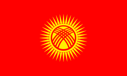
The flag of Kyrgyzstan consists of a red field charged with a yellow sun that contains a depiction of a tunduk, the opening in the center of the roof of a yurt. Adopted in 1992, just over seven months after the country's independence was declared, to replace the flag of the Kirghiz Soviet Socialist Republic (SSR), it has been the flag of the Kyrgyz Republic since that year. The red on the flag is said to be inspired by the pennant lifted by Manas, the country's folk hero.

The Chu is a river in Northern Kyrgyzstan and Southern Kazakhstan. Of its total length of 1,067 kilometres (663 mi), the first 115 kilometres are in Kyrgyzstan, then for 221 kilometres the river is the border between Kyrgyzstan and Kazakhstan and the last 731 kilometres are in Kazakhstan. It is one of the longest rivers in Kyrgyzstan and in Kazakhstan. It has a drainage basin of 62,500 square kilometres (24,100 sq mi).

Chüy Region is the northernmost region (oblast) of the Kyrgyz Republic. This region surrounds the national capital of Kyrgyzstan, Bishkek. It is bounded on the north by Kazakhstan, and clockwise, Issyk-Kul Region, Naryn Region, Jalal-Abad Region, and Talas Region. Its administrative center is Bishkek. Its total area is 19,895 km2 (7,682 sq mi). The resident population of the region was 974,984 as of January 2021. The region has sizeable Russian and Dungan minorities. It takes its name from the river Chüy, that flows through the region.

Jalal-Abad Region is a region (oblast) of Kyrgyzstan. Its capital is the city of the same name, Jalal-Abad. It is surrounded by Talas Region, Chüy Region, Naryn Region, Osh Region, and Uzbekistan. Jalal-Abad Region was established on 21 November 1939. On 27 January 1959 it became a part of Osh Region, but regained its old status as a region on 14 December 1990. Its total area is 32,418 km2 (12,517 sq mi). The resident population of the region was 1,260,617 as of January 2021. The region has a sizeable Uzbek minority.

Kyrgyz Premier League or OLIMPBET Premier League for sponsorship purposes is the division of professional football in Kyrgyzstan. It was created in 1992 after the Dissolution of the Soviet Union. The league is composed of eight teams. The most successful team is Dordoi Bishkek who have won the league thirteen times.

Although Kyrgyzstan’s mountains and lakes are an attractive tourist destination, the tourism industry has grown very slowly because it has received little investment. In the early 2000s, an average of about 450,000 tourists visited annually, mainly from countries of the former Soviet Union. In 2018, the British Backpacker Society ranked Kyrgyzstan as the fifth best adventure travel destination on earth, stating that the country was an adventure travel secret that is "bound to get out soon."
The regions of Kyrgyzstan are divided into districts (raions), administered by government-appointed officials. Rural communities consisting of up to twenty small settlements have their own elected mayors and councils. The raions are listed below, by region:

The Kirghiz Soviet Socialist Republic, also known as the Kyrgyz Soviet Socialist Republic or Kirgiz Soviet Socialist Republic, was one of the constituent republics of the Soviet Union (USSR) from 1936 to 1991. It was also known by the names Kyrgyzstan and Soviet Kyrgyzstan in the Kyrgyz language, and as Kirghizia and Soviet Kirghizia in the Russian language. Landlocked and mountainous, it bordered Tajikistan and China to the south, Uzbekistan to the west and Kazakhstan to the north. The Kirghiz branch of the Communist Party of the Soviet Union governed the republic from 1936 until 1990.

Kemin is the northeast panhandle district of Chüy Region in northern Kyrgyzstan. Its area is 3,533 square kilometres (1,364 sq mi), making it the largest district of Chüy Region, and its resident population was 48,360 in 2021. Its administrative headquarters is at Kemin. The district is located in the Chong-Kemin Valley, the Kichi-Kemin Valley and the eastern part of the Chüy Valley. It borders with Kazakhstan in the north, Chüy District in the west, and Issyk-Kul Region in the south and east.
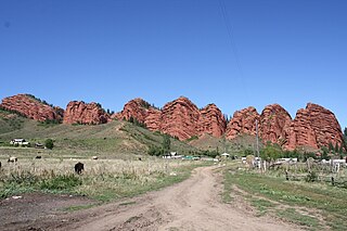
Jeti-Ögüz is a district of Issyk-Kul Region in north-eastern Kyrgyzstan. Its seat lies at Kyzyl-Suu. Its area is 14,499 square kilometres (5,598 sq mi), and its resident population was 93,392 in 2021. It comprises much of the eastern end of the Terskey Ala-Too Range.
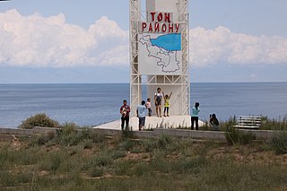
Tong is a district of Issyk-Kul Region in north-eastern Kyrgyzstan. The seat lies at Bökönbaev. Its area is 7,230 square kilometres (2,790 sq mi), and its resident population was 53,401 in 2021. Tong District borders Issyk-Kul District to the north-west, Jeti-Ögüz District to the south and south-east, Kochkor District to the south-west, Naryn District to the south, Kemin District to the north-west, and Issyk Kul - to the north.
The Kichi Ak-Suu Forest Reserve is located in the Anan'yevo rural community, Issyk-Kul District, Issyk-Kul Region, Kyrgyzstan. Established in 1977, it covers 100 hectares on the south slopes of the Küngöy Ala-Too Range. Its purpose is conservation of natural forests composed of Short-needled Schrenk's spruce.
Ak-Suu may refer to the following places in Kyrgyzstan:
Toguz-Bulak may refer to the following places in Kyrgyzstan:
Kyzyl-Tuu may refer to the following places in Kyrgyzstan:
Kara-Suu may refer to the following places in Kyrgyzstan:
Sary-Bulak or Sarybulak may refer to the following places: