Firth is a word in the English and Scots languages used to denote various coastal waters in the United Kingdom, predominantly within Scotland. In the Northern Isles, it more often refers to a smaller inlet. It is linguistically cognate to fjord, which has a more constrained sense in English. Bodies of water named "firths" tend to be more common on the Scottish east coast, or in the southwest of the country, although the Firth of Clyde is an exception to this. The Highland coast contains numerous estuaries, straits, and inlets of a similar kind, but not called "firth" ; instead, these are often called sea lochs. Before about 1850, the spelling "Frith" was more common.


The Shipping Forecast is a BBC Radio broadcast of weather reports and forecasts for the seas around the British Isles. It is produced by the Met Office and broadcast by BBC Radio 4 on behalf of the Maritime and Coastguard Agency. The forecast dates back over 150 years. There are currently four broadcasts per day at the following times: 00:48, 05:20, 12:01, and 17:54.

Argyll, sometimes called Argyllshire, is a historic county and registration county of western Scotland.

The Mull of Kintyre is the southwesternmost tip of the Kintyre Peninsula in southwest Scotland. From here, the Antrim coast of Northern Ireland is visible on a calm and clear day, and a historic lighthouse, the second commissioned in Scotland, guides shipping in the intervening North Channel. The area has been immortalised in popular culture by the 1977 hit song "Mull of Kintyre" by Kintyre resident Paul McCartney's band of the time, Wings.

A tidal island is a raised area of land within a waterbody, which is connected to the larger mainland by a natural isthmus or man-made causeway that is exposed at low tide and submerged at high tide, making the land switching between a promontory/peninsula and an island depending on tidal conditions.
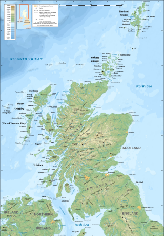
The geography of Scotland is varied, from rural lowlands to unspoilt uplands, and from large cities to sparsely inhabited islands. Located in Northern Europe, Scotland comprises the northern third of the island of Great Britain as well as 790 surrounding islands encompassing the major archipelagos of the Shetland Islands, Orkney Islands and the Inner and Outer Hebrides. The only land border is with England, which runs for 96 miles in a northeasterly direction from the Solway Firth in the west to the North Sea on the east coast. Separated by the North Channel, the island of Ireland lies 13 nautical miles from Mull of Kintyre on the Scottish mainland. Norway is located 190 nmi (350 km) northeast of Scotland across the North Sea. The Atlantic Ocean, which fringes the coastline of western and northern Scotland and its islands, influences the temperate, maritime climate of the country.
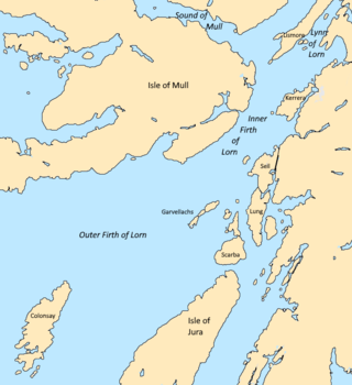
The Firth of Lorn or Lorne is the inlet of the sea between the south-east coast of the Isle of Mull and the mainland of Scotland. It includes a number of islands, and is noted for the variety of wildlife habitats that are found. In 2005, a large part of the Firth became a Special Area of Conservation.
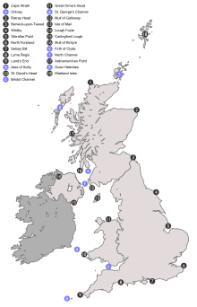
The coastline of the United Kingdom is formed by a variety of natural features including islands, bays, headlands and peninsulas. It consists of the coastline of the island of Great Britain, the north-east coast of the island of Ireland, as well as many much smaller islands. Much of the coastline is accessible and quite varied in geography and habitats. Large stretches have been designated areas of natural beauty, notably the Jurassic Coast and various stretches referred to as heritage coast. They are both very long, spreading through the mainland.

Selsey Bill is a headland into the English Channel on the south coast of England in the county of West Sussex.

The Inner Seas off the West Coast of Scotland is a marine area designated by the International Hydrographic Organization (IHO). It consists of a number of waterbodies between the Scottish mainland, the Outer Hebrides islands, and the coast of Ireland.
The Scottish Coastal Way is a proposed national long-distance trail that goes around the coastline of mainland Scotland. The idea was first proposed by walkers, and in November 2009 Scottish Natural Heritage (SNH) hosted a conference on the subject. In 2010 SNH estimated that around 2,700 km of coastal paths and routes were existence, compared to a total coastline length of 10,192 km. The existing coastal paths were predominantly in the more populous parts of the country, and few coastal paths exist in more remote areas such as Highlands and Islands. It was recognised that a coastal route, along the lines of the Wales Coast Path, would have many positives, but that development of a fully waymarked route would conflict with conservation aims such as the preservation of the "wild land" qualities of much of the Scottish coast.
This page is based on this
Wikipedia article Text is available under the
CC BY-SA 4.0 license; additional terms may apply.
Images, videos and audio are available under their respective licenses.