Lake Street/Midtown station

Last updated
Lake Street/Midtown
Lake St-Midtown station.jpg
Lake Street/Midtown station platform
General information
Location2310 Lake Street East
Minneapolis, Minnesota
Coordinates 44°56′54″N93°14′20″W / 44.9483°N 93.2389°W / 44.9483; -93.2389
Owned by Metro Transit
Platforms1 island platform
Tracks2
ConnectionsAiga bus trans.svg Metro Transit: 21, 27, 53
Construction
Structure typeElevated
AccessibleYes
History
OpenedJune 26, 2004 (2004-06-26)
Services
Preceding station Metro Minnesota icon.svg Metro Following station
Franklin Avenue
toward Target Field
Blue Line 38th Street
Location
Lake Street/Midtown station

Lake Street/Midtown station, also referred locally as either the Lake Street station or Midtown station, is a Blue Line light rail stop in Minneapolis, Minnesota, United States. The station is located on a bridge over East Lake Street adjacent to Highway 55.

Contents

The station offers connections to buses on Lake Street which include Route 21. The future Metro B Line will have stations below the Blue Line station on Lake Street. An eastbound BRT station was built in 2015 and while the west station will be built in 2024 for an expected opening of the B Line in June 2025.

Description

This elevated station spans over East Lake Street along the west side of Minnesota State Highway 55, which is known as Hiawatha Avenue along this stretch of road. This is a center-platform station. Along with the Franklin Avenue station, the Lake Street/Midtown station is one of the two above-grade stations on the Blue Line. Service began at this station when the Blue Line opened on June 26, 2004.

The Midtown Station is one of four stations immediately adjacent to Hiawatha Avenue. Others include 38th Street Station, 46th Street Station, and 50th Street Station. The Hiawatha Corridor features a wide variety of architecture including grain elevators, subsidized housing, and well-established neighborhoods, such as Longfellow and Corcoran.

Just north of the station, the Blue Line crosses over Hiawatha Avenue on a concrete box girder flyover before returning to grade level.

The seasonal Midtown Farmers' Market operates weekly on a space immediately adjacent to the station. The market features produce, meat, cheese, bread, eggs, flowers, crafts, hot food, music and family-oriented entertainment.

In July 2008, local residents teamed up with Metro Transit and Xcel Energy to decorate several electric boxes situated between the station and the park and ride lot. The murals painted on the structures depict grain stalks on a blue sky, and are intended to represent the Midtown Farmers' Market held adjacent to the station. Local residents also encouraged Metro Transit to install sidewalks and stairs along lines of bare dirt where riders frequently cut through a sloping grassy area. This improved station access and reduced erosion problems. [1]

This station is planned to be served as the terminus of the Minneapolis Streetcar System's Midtown Greenway Line .

Park and Ride lot

Upon opening, the station hosted a 170-space park and ride lot immediately southwest of the station, leased from Anishinabe Academy elementary school. [2] The lot was only planned to exist temporarily and close when park and ride lots outside Minneapolis opened. [3]

It was regularly filled beyond capacity, with parking overflowing into aisles and onto nearby streets. [3] Residents have complained about the lack of parking (and specifically the overflow onto streets) at neighborhood meetings. Crime has also been an intermittent problem in the parking lot, with victims attributing the lot's poor overhead lighting as a major contributing factor. Local residents and the neighborhood organization called upon Metro Transit to improve the lighting situation, but the process has been complicated by the fact that Metro Transit did not own the lot, but merely leased it from the public school district.

This lot was the only park and ride lot on the Blue Line within the city of Minneapolis. The lot closed March 7, 2015 for redevelopment. [4] There are over 2,500 park and ride spaces at Fort Snelling station and 28th Avenue station at the southern end of the Blue Line.

Bus connections and future bus rapid transit

From the station, passengers go down one level to make direct connections to bus routes 21, 27, and 53. [3]

The station will be a stop on the Metro B Line, an under construction bus rapid transit line that will substantially replace Route 21 along Lake Street and Selby Avenue. Route 21 currently carries 10,000 passengers every weekday, while only making up 2% of traffic on Lake Street. Improvements would include specialized stations and buses and frequent all-day service. To speed up travel times, which usually slows to 8 mph (13 km/h) during rush hours, off-board fare collection, near-level boarding, and transit signal priority will be implemented.

When the line opens, it will provide a crosstown connection to Southwest LRT, Metro E Line, Orange Line, D Line, and A Line with the final terminus at Union Depot in downtown Saint Paul, Minnesota. The eastbound BRT station was constructed in 2015 and includes a distinct shelter and station marker, near-level boarding, heating and lighting, and infrastructure for off-board fare collection once the B Line begins operating. The B Line went through engineering in 2020, with construction starting in 2023, and passenger operations beginning in 2024. [5]

Future

Since opening 20 years ago, the condition of the station has declined with frequent vandalism, shattered glass, broken elevators and escalators, and higher levels of crime. Since 2023 there have been security guards positioned at the station which transit officials say have been effective at reducing crime. [6] [7] [8] There have been several high profile shootings and assaults at the station. [9] [10]

In 2024, the Metropolitan Council awarded a contract to redesign the station with construction potentially beginning in 2025. [6] The light rail system in Minnesota is based on proof-of-payment but the Metropolitan Council is considering enclosing the station with faregates. [11]

Notable places nearby

Related Research Articles

<span class="mw-page-title-main">Metro Blue Line (Minnesota)</span> Light rail line in Hennepin County, Minnesota

The Metro Blue Line is a 12-mile (19.3 km) light rail line in Hennepin County, Minnesota, that is part of the Metro network. It travels from downtown Minneapolis to Minneapolis–Saint Paul International Airport and the southern suburb of Bloomington. Formerly the Hiawatha Line prior to May 2013, the line was originally named after the Milwaukee Road's Hiawatha passenger train and Hiawatha Avenue, reusing infrastructure from the former and running parallel to the latter for a portion of the route. The line opened June 26, 2004, and was the first light rail service in Minnesota. An extension, Bottineau LRT, is planned to open in 2028.

Metro Transit is the primary public transportation operator in the Minneapolis–Saint Paul area of the U.S. state of Minnesota and the largest operator in the state. Although Metro Transit is one of the smallest transit systems for a large metropolitan area in the United States, it has previously been ranked as one of the best. In 2023, the system had a ridership of 44,977,200, or about 145,600 per weekday as of the fourth quarter of 2023.

<span class="mw-page-title-main">Metro Green Line (Minnesota)</span> Light rail transit line in Minnesota, US

The Metro Green Line is an 11-mile (18 km) light rail line that connects the central business districts of Minneapolis and Saint Paul in Minnesota as well as the University of Minnesota. An extension is under construction that will extend the line to the southwest connecting St. Louis Park, Hopkins, Minnetonka and Eden Prairie. The line follows the path of former Metro Transit bus route 16 along University Avenue and Washington Avenue. It is the second light-rail line in the region, after the Blue Line, which opened in 2004 and connects Minneapolis with the southern suburb of Bloomington.

<span class="mw-page-title-main">Nicollet Mall station</span>

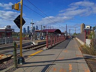
Nicollet Mall station is a light rail station on the Metro Blue Line and Green Line in Minneapolis, Minnesota. Adjacent to the light rail platforms is the southbound Metro Orange Line bus rapid transit station Marquette & 5th Street.

<span class="mw-page-title-main">Government Plaza station</span> Light rail station in Minneapolis, Minnesota

Government Plaza station is a Metro light rail station on the Blue Line and Green Line in Minneapolis, Minnesota. The station is located on 5th Street South, between 3rd and 4th Avenues South in downtown Minneapolis. This station opened on June 26, 2004, with initial light rail service in the Twin Cities.

<span class="mw-page-title-main">U.S. Bank Stadium station</span> A Minneapolis, Minnesota light rail station, named for the neighboring U.S. Bank Stadium.

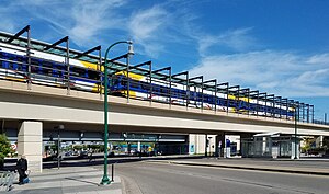
U.S. Bank Stadium station station is a light rail station on the Metro Blue Line and Green Line in Minneapolis, Minnesota.

<span class="mw-page-title-main">Franklin Avenue station (Metro Transit)</span>

Franklin Avenue station is a light rail station on the Blue Line in Minneapolis, Minnesota.

<span class="mw-page-title-main">38th Street station (Metro Transit)</span>

38th Street station is a light rail station on the Blue Line in Minneapolis, Minnesota.

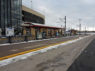
46th Street station is a light rail station on the Metro Blue Line in Minneapolis, Minnesota. This station is located on the northwest corner of the intersection of 46th Street and Minnesota State Highway 55, in the Ericsson neighborhood. This is a side-platform station. Service began at this station when the Blue Line opened on June 26, 2004.

<span class="mw-page-title-main">30th Avenue station (Metro Transit)</span> Light rail station in Bloomington, Minnesota

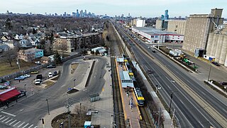
30th Avenue station is a light rail and bus station on the Blue Line in the Twin Cities region of the U.S. state of Minnesota. The station opened with the second phase of the Hiawatha Line on December 4, 2004. It has a 1,585-space park and ride facility. The south parking lot was closed for construction of a 1,443 space parking ramp, which opened in Fall 2008.

<span class="mw-page-title-main">Mall of America station</span> Light rail and bus station in Bloomington, Minnesota

The Mall of America station is the busiest transit center in Minnesota, with bus and light rail service linking the Mall of America to many destinations in the Minneapolis–St. Paul metro. Public transit service is provided by Metro Transit and the Minnesota Valley Transit Authority. The station is served by Metro Blue Line, Red Line, and D Line. The station previously hosted private shuttle services to hotels and Mystic Lake Casino until those services moved to a new charter bus terminal on the north side of the mall in 2015.

<span class="mw-page-title-main">Lake Street (Minneapolis)</span>

Lake Street is a major east-west thoroughfare between 29th and 31st streets in Minneapolis, Minnesota United States. From its western most end at the city's limits, Lake Street reaches the Chain of Lakes, passing over a small channel linking Bde Maka Ska and Lake of the Isles, and at its eastern most end it reaches the Mississippi River. In May 2020, the Lake Street corridor suffered extensive damage during local unrest following the murder of George Floyd. In August of the same year, city officials designated East Lake Street as one of seven cultural districts to promote racial equity, preserve cultural identity, and promote economic growth.

<span class="mw-page-title-main">Southwest LRT</span> Under-construction light rail transit line in Minneapolis

The Southwest LRT is an under–construction 14.5-mile (23.3 km) light rail transit corridor in Hennepin County, Minnesota, with service between Minneapolis and Eden Prairie. The estimated one-way travel time from Southwest Station in Eden Prairie to Target Field Station in Minneapolis is 32 minutes. The Southwest LRT will extend through St. Louis Park, Hopkins and Minnetonka along the route. Major locations on the line will include Bde Maka Ska, Cedar Lake, the Walker Art Center, the Minneapolis Sculpture Garden and Target Field in downtown Minneapolis.

The Midtown Farmers Market is a seasonal open-air farmers market in the Midtown area of south Minneapolis. Established in 2003, the market is held Saturdays from May through October, and Tuesdays from June through October in a parking lot in the Corcoran neighborhood. The market is a project of the Corcoran Neighborhood Organization, and is known for a selection of locally produced and organic fare. All of the products sold at the market are grown or produced in Minnesota or Wisconsin by the individual vendors. At the peak of the season, the Saturday market hosts over 70 vendors and draws over 60,000 shoppers each season.

<span class="mw-page-title-main">Metro (Minnesota)</span> Rapid transit network in the Minneapolis metropolitan area of the United States

Metro is a transit network in Minnesota serving the cities of Minneapolis and Saint Paul. It also provides service to some suburban areas. As of 2022, the system consists of two light rail lines and five bus rapid transit (BRT) lines all of which are operated by the local public transit company: Metro Transit. The five lines connect Downtown Minneapolis and St Paul with the Bloomington, Minneapolis-St Paul International Airport, Roseville, Richfield, Burnsville and Brooklyn Center.

<span class="mw-page-title-main">Metro B Line (Minnesota)</span> Planned bus rapid transit line in the Minneapolis metropolitan area of the United States

The Metro B Line is an under construction bus rapid transit route in Minneapolis and St. Paul. The route will operate mostly on Lake Street in Minneapolis before crossing the Mississippi River into St. Paul and operating mostly on Selby Avenue and ending in downtown St. Paul. The route was identified in Metro Transit's 2014 Arterial Transitway Corridors Study as one of eleven local routes to be upgraded to bus rapid transit. The route will have "train-like" features to speed up service, such as signal priority, all-door boarding, further stop spacing, and specialized vehicles. Planning and design was completed in 2021, with construction beginning in May 2023. The line will join a number of Metro Transit's future Metro system lines, as well as the currently operating A Line, C Line, and D Line. Full funding for the line was secured in October 2020 with a final $35 million from the state of Minnesota.

<span class="mw-page-title-main">Hiawatha LRT Trail</span> Shared-use path in Minneapolis

Hiawatha LRT Trail is a 4.7-mile (7.6 km), multi-use path adjacent to a light-rail transit line in Minneapolis, Minnesota, United States, that is popular with bicycle commuters. Users travel along the Metro Blue Line and Hiawatha Avenue transit corridor, reaching downtown Minneapolis near an indoor sports stadium at the trail’s northern end, and reaching a bridge above Minnehaha Creek at the trail’s southern end. Hiawatha LRT Trail provides a vital link between several Minneapolis neighborhoods and the city’s downtown area.

<span class="mw-page-title-main">Little Earth Trail</span> Shared-use path in Minneapolis

Little Earth Trail is an approximately 1-mile (1.6 km), multi-use bicycle path in Minneapolis, Minnesota, United States, that links several neighborhoods, parks, businesses, and trails in the Phillips community. The trail begins at its northern end near the intersection of East Franklin Avenue and 16th Avenue South and eventually follows the west side of Hiawatha Avenue to the Midtown Greenway and Martin Olav Sabo Bridge. Named after the nearby Little Earth community, the shared-use pathway provides transportation and recreation opportunities, and is a frequent location of activism on social justice issues in Minneapolis.

<span class="mw-page-title-main">Min Hi Line</span> Proposed linear park and shared-use path in Minneapolis

Min Hi Line is a proposed linear park and shared-use path that would eventually re-purpose an active rail and agri-industrial corridor in the Longfellow community of Minneapolis, Minnesota, United States. Modeled after successful projects like the Atlanta Beltline and New York High Line, it would feature an approximately 3-mile (4.8 km), shared-use pathway that traverses housing, retail, commercial buildings, gardens, playgrounds, and public art installments. Two pilot projects completed in 2018 and 2019 connect the Min Hi Line corridor to trail systems at its northern and southern ends.

References

  1. Corcoran Neighborhood Organization (2008-07-08). "Corcoran residents champion improvements at light rail station". The Neighborhood Advocate. Retrieved 2009-02-08.
  2. "Park for free then ride the smart way". Metro Transit. Archived from the original on April 13, 2010. Retrieved 2009-02-08.
  3. 1 2 3 Harlow, Tim (February 23, 2015). "Lake Street/Midtown park-and-ride lot closing March 7". Star Tribune. Retrieved 7 January 2024.
  4. "Lake Street/Midtown Station Park & Ride will close March 7". Metro Transit . Retrieved 12 February 2015.
  5. "B Line Project". www.metrotransit.org. Metro Transit. Retrieved 4 November 2019.
  6. 1 2 Moore, Janet (6 January 2024). "Overhaul planned for the troubled Lake Street/Midtown LRT station". Star Tribune. Retrieved 6 January 2024.
  7. Moore, Janet (August 15, 2023). "Lake Street/Midtown Station cleaning up its act as Metro Transit takes proactive approach to crime". Star Tribune. Retrieved 7 January 2024.
  8. Schmidt, Rose (15 August 2023). "Metro Transit: Crime down at Lake Street-Midtown station after security changes". FOX 9. Retrieved 7 January 2024.
  9. Harlow, Tim (May 8, 2023). "Minneapolis City Council member: 'We need to act with urgency' on Lake Street LRT station". Star Tribune. Retrieved 6 January 2024.
  10. Sawyer, Liz (March 1, 2023). "Two charged in brutal attack of transgender woman at Lake Street light-rail station". Star Tribune. Retrieved 7 January 2024.
  11. Sukhram, Daren (1 December 2023). "New calls to 'enclose every station' in response to crime on Twin Cities light rail". KSTP.com 5 Eyewitness News. Retrieved 7 January 2024.