Chesapeake is an independent city in the Commonwealth of Virginia. As of the 2010 census, the population was 222,209; in 2019, the population was estimated to be 244,835, making it the second-most populous city in Virginia.
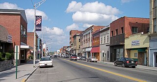
Princeton, is a city in and the county seat of Mercer County, West Virginia, United States. The city has often been referred to as the “Jewel of the South” or the “Heart of Mercer County” more recently. The population was 6,432 at the 2010 census. It is part of the Bluefield, WV-VA micropolitan area which has a population of 107,342. The city hosts the Princeton Rays baseball club of the Appalachian League.

The Norfolk Naval Shipyard, often called the Norfolk Navy Yard and abbreviated as NNSY, is a U.S. Navy facility in Portsmouth, Virginia, for building, remodeling, and repairing the Navy's ships. It is the oldest and largest industrial facility that belongs to the U.S. Navy as well as the most multifaceted. Located on the Elizabeth River, the yard is just a short distance upriver from its mouth at Hampton Roads.

The Virginia Peninsula is a peninsula in southeast Virginia, USA, bounded by the York River, James River, Hampton Roads and Chesapeake Bay. It is sometimes known as the Lower Peninsula to distinguish it from two other peninsulas to the north, the Middle Peninsula and the Northern Neck.

The Elizabeth River is a 6-mile-long (10 km) tidal estuary forming an arm of Hampton Roads harbor at the southern end of Chesapeake Bay in southeast Virginia in the United States. It is located along the southern side of the mouth of the James River, between the cities of Portsmouth, Norfolk, and Chesapeake. Forming the core of the Hampton Roads harbor, it is heavily supported by its tributaries which depend upon it.
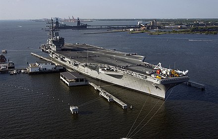
Sewells Point is a peninsula of land in the independent city of Norfolk, Virginia, in the United States, located at the mouth of the salt-water port of Hampton Roads. Sewells Point is bordered by water on three sides, with Willoughby Bay to the north, Hampton Roads to the west, and the Lafayette River to the south. It is the site of Naval Station Norfolk.

South Hampton Roads is a region located in the extreme southeastern portion of Virginia's Tidewater region in the United States with a total population of 1,191,937. It is part of the Virginia Beach-Norfolk-Newport News, VA-NC MSA, which itself has a population of 1,724,876.
The Battle of Sewell's Point was an inconclusive exchange of cannon fire between the Union gunboat USS Monticello, supported by the USS Thomas Freeborn, and Confederate batteries on Sewell's Point that took place on May 18, 19 and 21, 1861, in Norfolk County, Virginia in the early days of the American Civil War. Little damage was done to either side. By the end of April 1861, USS Cumberland and a small number of supporting ships were enforcing the Union blockade of the southeastern Virginia ports at the southern end of the Chesapeake Bay and had captured several ships which attempted to pass the blockade. USS Monticello's bombardment of the Sewell's Point battery was one of the earliest Union Navy actions against Confederate forces during the Civil War. While it has been suggested by some sources that the Monticello's action may have been the first gunfire by the Union Navy during the Civil War, a brief exchange of cannon fire between the U.S. gunboat USS Yankee and shore batteries manned by Virginia volunteer forces which had not yet been incorporated into the Confederate States Army at Gloucester Point, Virginia on the York River occurred on May 7, 1861.
37°0′0.5472″N76°18′42.8532″W

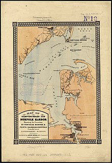
Norfolk County was a county of the South Hampton Roads in eastern Virginia in the United States that was created in 1691. After the American Civil War, for a period of about 100 years, portions of Norfolk County were lost and the territory of the county reduced as they were annexed by the independent and growing cities of Norfolk, Portsmouth and South Norfolk.
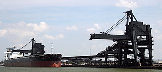
Lamberts Point is a point of land on the east shore of the Elizabeth River near the downtown area of the independent city of Norfolk in the South Hampton Roads region of eastern Virginia, United States. It includes a large coal exporting facility, a residential area, and a golf course. The area is south of Old Dominion University

Nansemond is an extinct jurisdiction that was located south of the James River in Virginia Colony and in the Commonwealth of Virginia in the United States, from 1646 until 1974. It was known as Nansemond County until 1972. From 1972 to 1974, a period of eighteen months, it was the independent city of Nansemond. It is now part of the independent city of Suffolk.
Francis Mallory was an American naval officer, physician, politician, and railroad executive.

Ocean View is a coastal region in the independent city of Norfolk, Virginia in the United States. It has several miles of shoreline on the Chesapeake Bay to the north, starting with Willoughby Spit to the west and the Joint Expeditionary Base -- Little Creek in the independent city of Virginia Beach on the east.
Naval Weapons Station Yorktown is a United States Navy base in York County, James City County, and Newport News in the Hampton Roads region of Virginia. It provided a weapons and ammunition storage and loading facility for ships of the United States Atlantic Fleet, and more recently, for those from the Fleet Forces Command.
Robert Buckner Claytor was an American railroad administrator. He became President of the Norfolk and Western Railway in 1981 and was instrumental in the merger of the Southern Railway and the Norfolk & Western in 1982. He was the first chairman and CEO of the new Norfolk Southern, and is credited with locating the headquarters of the Fortune 500 company in Norfolk, Virginia, within sight of the massive coal pier at Lambert's Point on the Elizabeth River at Hampton Roads.

Nauticus is a maritime-themed science center and museum located on the downtown waterfront in Norfolk, Virginia, also known as the National Maritime Center.

The Lafayette River, earlier known as Tanner's Creek, is a 6.2-mile-long (10.0 km) tidal estuary which empties into the Elizabeth River just south of Sewell's Point near its mouth at Hampton Roads, which in turn empties into the southern end of Chesapeake Bay in southeast Virginia in the United States. It is entirely located in the city of Norfolk, Virginia.
Since Norfolk serves as the commercial and cultural center for the geographical region of Hampton Roads, it can be difficult to separate the economic characteristics of Norfolk, from that of the region as a whole. The waterways which almost completely surround the Hampton Roads region also play an important part in the local economy. As a strategic location at the mouth of the Chesapeake Bay, its protected deep water channels serve as major arteries for the import and export of goods from across the Mid-Atlantic, Mid-West, and international destinations, as well as being the location of the world's largest naval base.
St. Julien's Creek Annex (SJCA) is a U.S. naval support facility that provides administrative offices, light industrial shops, and storage facilities for tenant naval commands. Its primary mission is to provide a radar testing range and various administrative and warehousing structures for the Norfolk Naval Station.