Little Tokyo/Arts District station

Last updated

Little Tokyo/Arts District
LACMTA Circle A Line.svg   LACMTA Circle E Line.svg  
Little Tokyo Arts District station platform.jpg
Little Tokyo/Arts District station platform
General information
Location402 East 1st Street
Los Angeles, California
Coordinates 34°02′55″N118°14′19″W / 34.0487°N 118.2387°W / 34.0487; -118.2387
Owned by Los Angeles County Metropolitan Transportation Authority
Platforms1 island platform
Tracks2
Connections Los Angeles Metro Bus
LADOT DASH
Construction
Structure typeUnderground
ParkingPaid parking nearby
Bicycle facilities Metro Bike Share station, [1] racks, lockers
AccessibleYes
History
OpenedNovember 15, 2009 (2009-11-15) (at-grade station) June 16, 2023 (2023-06-16) (underground station)
ClosedOctober 24, 2020 (2020-10-24) (at-grade station)
Rebuilt2020–2023
Services
Preceding station LAMetroLogo.svg Metro Rail Following station
Union Station
toward Azusa
A Line Historic Broadway
toward Long Beach
Historic Broadway
toward Santa Monica
E Line Pico/Aliso
Location
Little Tokyo/Arts District station

Little Tokyo/Arts District station is an underground light rail station on the Los Angeles Metro Rail system. It replaced an at-grade station with the same name that was located on the east side of Alameda Street between 1st Street and Temple Street, on the edge of Little Tokyo and the Arts District in Downtown Los Angeles. The at-grade station opened in 2009 as part of the Gold Line Eastside Extension and was served by the L Line. The at-grade station closed in October 2020, and the new underground station on the south side of 1st Street between Central Avenue and Alameda Street opened on June 16, 2023. [2]

Contents

History

Former services

The Little Tokyo/Arts District station was once a key area for trains in Downtown Los Angeles. James M. Davies, for whom the large tract was named, subdivided the area in 1891. Several railroad lines from different companies connected through this site. Davies great-nephew, Robert Davies Volk, was the owner of the lots at 1st and Alameda Streets with brick buildings shaped to fit the long-gone rail lines. [3] The structures had played an important role in the cultural life of the Little Tokyo neighborhood for decades before the site was cleared for the future station. [4] Los Angeles Railway P Line yellow streetcars operated on the surface of 1st Street [5] until 1963, including a call at Alameda.

At-grade station

Little Tokyo/Arts District station's former at-grade platform, 2009 Little Tokyo-Arts District Station LACMTA.jpg
Little Tokyo/Arts District station's former at-grade platform, 2009

On July 17, 2004, Metro began construction on a 6 miles (9.7 km) extension of the Gold Line light rail line called the Gold Line Eastside Extension, which replaced a once-planned Red Line (now the B Line) subway extension. [6] The light rail extension runs from Union Station through Little Tokyo, ending at the corner of Pomona and Atlantic Boulevards in East Los Angeles. One of the stations on the extension was the at-grade Little Tokyo/Arts District station, located east of Alameda Street between 1st and Temple Streets. The station began operations with the opening of the Eastside Extension on November 15, 2009. [7] However, the at-grade station only operated for eleven years.

In 2012, the Regional Connector Transit Project and its Environmental Impact Report were officially approved after eight years of formal studies. [8] The Regional Connector is a light rail tunnel through Downtown Los Angeles that connects the former Metro Rail A, E, and L (Gold) Lines. The Little Tokyo/Arts District station was planned to be served by both the restructured A Line, connecting Long Beach and the San Gabriel Valley, and the restructured E Line, connecting Santa Monica and East Los Angeles. Due to this, Metro needed to rebuild the original Gold Line (renamed the L Line in 2020) station, underground, south of 1st Street to serve both lines. The decision to rebuild the station underground was partly driven by traffic concerns on Alameda and 1st Streets caused by at-grade trains. [9]

The Regional Connector project started relocating utility pipes in December 2012 and heavy construction began two years later on September 30, 2014. [10] Due to the relocation of tracks for the project, the at-grade station was briefly closed in early 2016. [11] The station was again closed for a final time on October 24, 2020, before the new underground station opened 32 months later. Until the replacement station was completed, a bus bridge operated between Union Station and Pico/Aliso station for those riders traveling along the former L Line. [12]

Little Tokyo/Arts District station plaza under construction in February 2023 Little Tokyo Arts District station February 26, 2023.jpg
Little Tokyo/Arts District station plaza under construction in February 2023

Current underground station

When construction on the Regional Connector project started in September 2014, crews began building a replacement for the at-grade station. The rebuilt Little Tokyo/Arts District station is underground, located on the west side of Alameda Street with entrances 500 feet (150 m) south of the original station. The tunnel boring machines for the Regional Connector tunnel were also launched from that location. [13] The station was originally referred to as 1st St/Central in planning documents but was ultimately assigned the same name as the previous at-grade station in early 2017. [14]

Preliminary work for the underground station required the demolition of two modest single-story brick store buildings with one of the structures dating back to at least 1898. [4] However, new developments are being built on the blocks surrounding the station. [15]

Starting on April 9, 2023, the A, E, and L Line trains ran through the newly built station for final testing of the Regional Connector tunnel. [16] The new Little Tokyo/Arts District station officially opened with the new tunnel on June 16, 2023. [17] Beyond the Regional Connector opening, the Southeast Gateway Line plans to terminate downtown via a new light rail tunnel to Union Station. The line will feature a new transfer at Little Tokyo/Arts District station, which requires connecting the two subways with new infrastructure. [18]

Service

Station layout

SStreet plazaEntrance/Exit, faregates, ticket machines
CConcourseTo Entrance/Exit
P Platform levelNorthbound/
Eastbound
LACMTA Circle A Line.svg  A Line toward Azusa (Union Station)
LACMTA Circle E Line.svg  E Line toward East Los Angeles (Pico/Aliso)
Island platform, doors will open on the left
Southbound/
Westbound
LACMTA Circle A Line.svg  A Line toward Long Beach (Historic Broadway)
LACMTA Circle E Line.svg  E Line toward Santa Monica (Historic Broadway)

Hours and frequency

A Line service hours are from approximately 4:30 a.m. and 11:45 p.m daily. Trains operate every 8 minutes during peak hours, Monday through Friday. During weekday midday and weekends from 9:00 a.m. to 7:00 p.m., trains run every 10 minutes. Night and early morning service is approximately every 20 minutes every day. [19]

E Line service hours are from approximately 4:30 a.m. and 11:45 p.m daily. Trains operate every 8 minutes during peak hours, Monday through Friday. During weekday midday and weekends from 9:00 a.m. to 7:00 p.m., trains run every 10 minutes. Night and early morning service is approximately every 20 minutes every day. [20]

Connections

As of December 10,2023, the following connections are available: [21] [22]

Notable places nearby

The station is within walking distance of the following notable places: [23]

Related Research Articles

<span class="mw-page-title-main">Union Station (Los Angeles)</span> Main railroad station in Los Angeles, California

Los Angeles Union Station is the main train station in Los Angeles, California, and the largest passenger rail terminal in the Western United States. It opened in May 1939 as the Los Angeles Union Passenger Terminal, replacing La Grande Station and Central Station.

<span class="mw-page-title-main">Los Angeles Metro Rail</span> Urban rail transit system serving Los Angeles County, California

The Los Angeles Metro Rail is an urban rail transit system serving Los Angeles County, California in the United States. It consists of six lines: four light rail lines and two rapid transit lines, serving a total of 101 stations. It connects with the Metro Busway bus rapid transit system, the Metrolink commuter rail system, as well as several Amtrak lines. Metro Rail is owned and operated by the Los Angeles County Metropolitan Transportation Authority (Metro).

<span class="mw-page-title-main">B Line (Los Angeles Metro)</span> Rapid transit line in Los Angeles, California

The B Line is a fully underground 14.7 mi (23.7 km) rapid transit line operating in Los Angeles, running between North Hollywood and Downtown Los Angeles. It is one of six lines in the Los Angeles Metro Rail system, operated by the Los Angeles County Metropolitan Transportation Authority. Built in four stages between 1986 and 2000, the line cost $4.5 billion.

<span class="mw-page-title-main">A Line (Los Angeles Metro)</span> Light rail line in Los Angeles County, California

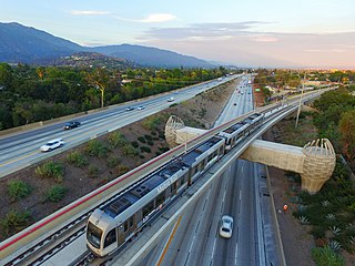
The A Line is a 48.5-mile (78.1 km) light rail line in Los Angeles County, California. It is one of the six lines of the Los Angeles Metro Rail system, operated by the Los Angeles County Metropolitan Transportation Authority (Metro). The A Line serves 44 stations and runs east-west between Azusa and Pasadena, then north-south between Pasadena and Long Beach. It interlines and shares five stations with the E Line in Downtown Los Angeles. Service operates for approximately 19 hours with headways of up to 8 minutes during peak hours. The A Line is currently the longest light rail line in the world.

<span class="mw-page-title-main">L Line (Los Angeles Metro)</span> Former light rail line

The L Line and Gold Line are former designations for a section of the current Los Angeles Metro Rail system. These names referred to a single light rail line of 31 miles (50 km) providing service between Azusa and East Los Angeles via the northeastern corner of Downtown Los Angeles, serving several attractions, including Little Tokyo, Union Station, the Southwest Museum, Chinatown, and the shops of Old Pasadena. The line, formerly one of seven in the system, entered service in 2003. The L Line served 26 stations.

<span class="mw-page-title-main">E Line (Los Angeles Metro)</span> Light rail line in Los Angeles County, California

The E Line is a 22-mile (35 km) light rail line in Los Angeles County, California. It is one of the six lines of the Los Angeles Metro Rail system, operated by the Los Angeles County Metropolitan Transportation Authority (Metro). The E Line runs east-west and serves 29 stations between East Los Angeles and Santa Monica. It interlines and shares five stations with the A Line in Downtown Los Angeles. Service operates for approximately 19 hours with headways of up to 8 minutes during peak hours. The E Line, the second-busiest light rail line in the system, saw an average of 41,902 passengers on weekdays in October 2023.

<span class="mw-page-title-main">Pico station</span> Los Angeles Metro Rail station

Pico station is an at-grade light rail station on the Los Angeles Metro Rail system located on Flower Street at the intersection of Pico Boulevard. The station also has southbound bus stops on Flower Street, across from the station and northbound bus stops on Figueroa Street, one block to the west. Pico station serves the South Park and Figueroa/Convention District neighborhoods.

<span class="mw-page-title-main">Arts District, Los Angeles</span> Neighborhood of Los Angeles in California, United States

The Arts District is a neighborhood on the eastern edge of Downtown Los Angeles, California in the United States. The city community planning boundaries are Alameda Street on the west which blends into Little Tokyo, First Street on the north, the Los Angeles River to the east, and Violet Street on the south. Largely composed of industrial buildings dating from the early 20th century, the area has recently been revitalized, and its street scene slowly developed in the early 21st century. New art galleries have increased recognition of the area amidst the downtown, which is known for its art museums.

<span class="mw-page-title-main">D Line (Los Angeles Metro)</span> Rapid transit line in Los Angeles, California

The D Line is a fully underground 5.1-mile (8.2 km) rapid transit line operating in Los Angeles, running between Koreatown and Downtown Los Angeles. It is one of six lines on the Metro Rail system, operated by the Los Angeles County Metropolitan Transportation Authority.

<span class="mw-page-title-main">Regional Connector</span> Transit project in Los Angeles

The Regional Connector Transit Project constructed a 1.9-mile (3.1 km) light rail tunnel for the Los Angeles Metro Rail system in Downtown Los Angeles. It connected the A and E lines with the former L Line. The A and E lines previously both terminated at 7th Street/Metro Center station, coming from Long Beach and Santa Monica, respectively, while the L Line ran through Little Tokyo/Arts District to either Azusa or East Los Angeles. Now the A and E lines continue together through new stations at Grand Avenue Arts/Bunker Hill, Historic Broadway, and Little Tokyo/Arts District. From there, they diverge on the former L Line toward Azusa and East Los Angeles, respectively. The project provides a one-seat ride into the core of Downtown for passengers on those lines who previously needed to transfer, thus reducing or altogether eliminating many transfers of passengers traveling across the region via Downtown Los Angeles.

Alameda Street is a major north-south thoroughfare in Los Angeles County, California. It is approximately 21 miles in length, running from Harry Bridges Boulevard in Wilmington; and through Carson, Compton, Lynwood, Watts, Florence-Graham, Huntington Park, Vernon and Arts District to Spring and College in Chinatown. For much of its length, Alameda runs through present and former industrial corridors, and is paralleled by Union Pacific Railroad tracks.

<span class="mw-page-title-main">Mariachi Plaza station</span> Los Angeles Metro Rail station

Mariachi Plaza station is an underground light rail station on the E Line of the Los Angeles Metro Rail system. It is located under 1st Street at the intersection of Boyle Avenue, with the main exit located at Mariachi Plaza, after which the station is named. The plaza is the historic gateway to the Boyle Heights neighborhood of Los Angeles. This station opened in 2009 as part of the Gold Line Eastside Extension and was one of two underground stations on the Eastside Extension.

<span class="mw-page-title-main">Atlantic station (Los Angeles Metro)</span> Light rail station in East Los Angeles, California

Atlantic station is an at grade light rail station on the E Line of the Los Angeles Metro Rail system. It is located at the intersection of Atlantic and Pomona Boulevards in East Los Angeles.

<span class="mw-page-title-main">Indiana station (Los Angeles Metro)</span> Los Angeles Metro Rail station

Indiana station is an at-grade light rail station on the E Line of the Los Angeles Metro Rail system. It is located alongside South Indiana Street as the line transitions between 1st Street and 3rd Street on the eastern edge of the Boyle Heights neighborhood of Los Angeles. This station opened in 2009 as part of the Gold Line Eastside Extension.

<span class="mw-page-title-main">Soto station</span> Los Angeles Metro Rail station

Soto station is an underground light rail station on the E Line of the Los Angeles Metro Rail system. It is located underneath 1st Street at its intersection with Soto Street in the heart of the Boyle Heights neighborhood of Los Angeles. This station opened in 2009 as part of the Gold Line Eastside Extension and was one of two underground stations on the Eastside Extension.

<span class="mw-page-title-main">Pico/Aliso station</span> Los Angeles Metro Rail station

Pico/Aliso station is an at-grade light rail station on the E Line of the Los Angeles Metro Rail system. It is located in the median of East 1st Street between South Anderson Street and South Utah Street in the Boyle Heights neighborhood of Los Angeles. This station opened on November 15, 2009, as part of the Gold Line Eastside Extension.

The Southeast Gateway Line, formerly the West Santa Ana Branch Transit Corridor, is a planned light rail line, mostly following the Pacific Electric's historic West Santa Ana Branch, connecting Downtown Los Angeles to the city of Artesia, along with other cities in southeastern Los Angeles County.

<span class="mw-page-title-main">Eastside Transit Corridor</span> Future light rail line extension in Los Angeles County, California

The Eastside Transit Corridor is a light rail line extension that currently connects Downtown Los Angeles with East Los Angeles. However, the extension is planned to extend further southeast to connect with the Gateway Cities, continuing from a relocated Atlantic station southeast to a new Lambert station in Whittier.

The history of the Los Angeles Metro Rail and Busway system begins in the early 1970s, when the traffic-choked region began planning a rapid transit system. The first dedicated busway opened along I-10 in 1973, and the region's first light rail line, the Blue Line opened in 1990. Today the system includes over 160 miles (260 km) of heavy rail, light rail, and bus rapid transit lines, with multiple new lines under construction as of 2019.

References

  1. "Station Map". Metro Bike Share . January 27, 2015. Archived from the original on January 2, 2022. Retrieved November 13, 2021.
  2. Von Quednow, Cindy (June 16, 2023). "Metro Regional Connector opens in Los Angeles, bringing more direct access to downtown". KTLA . Nexstar Media Group . Retrieved June 16, 2023.
  3. Fischer, Greg (August 26, 2014). "Tracking Some Early Train History: Upcoming Regional Connector Station Site Played a Key Role in L.A.'s Early Transportation Scene". Los Angeles Downtown News . Civic Center News, Inc. Archived from the original on August 29, 2014. Retrieved August 30, 2014.
  4. 1 2 Zahniser, David (March 15, 2014). "Buildings slated for tear-down were rich part of Little Tokyo history". Los Angeles Times . Archived from the original on April 7, 2014. Retrieved April 5, 2014.
  5. H.P. Noordwal (1938). "Route Map Los Angeles Railway Electric Car and Bus Routes" (Map). Barry Lawrence Ruderman Antique Maps Inc. Los Angeles Railway. Archived from the original on January 31, 2021. Retrieved January 26, 2021. "Alternate link" (Map). via Google . Archived from the original on January 31, 2021. Retrieved January 26, 2021.
  6. "Projects and Plans - Metro Gold Line Eastside Extension". Los Angeles County Metropolitan Transportation Authority. Archived from the original on August 28, 2004. Retrieved April 14, 2024.
  7. "After decades of waiting, their trains have arrived : Residents share a sense of kinship and progress aboard East L.A.'s new Gold Line route". Los Angeles Times. November 16, 2009. Retrieved December 28, 2023.
  8. Sotero, Dave (April 26, 2012). "Metro Board certifies final environmental study for Regional Connector". The Source. Retrieved December 22, 2023.
  9. "Regional Connector Update". The Source. Los Angeles County Metropolitan Transportation Authority. Archived from the original on April 30, 2010. Retrieved April 29, 2010.
  10. Hymon, Steve (October 1, 2014). "Ground is broken for Regional Connector project to link Blue, Expo and Gold Lines". The Source. Retrieved June 20, 2023.
  11. "Little Tokyo/Arts District Station Closure". Archived from the original on February 22, 2016. Retrieved January 13, 2015.
  12. Hymon, Steve (September 15, 2020). "Bus shuttles to replace L Line (Gold) service between Union Station and Pico/Aliso Station during 22-month closure to complete Regional Connector". Metro. The Source. Archived from the original on September 24, 2020. Retrieved September 16, 2020.
  13. "Metro Lowers 'Angeli' the Regional Connector Tunnel Boring Machine - Streetsblog Los Angeles". la.streetsblog.org. October 19, 2016. Retrieved December 25, 2023.
  14. "Actions taken today by the Metro Board of Directors". February 23, 2017. Archived from the original on May 13, 2017. Retrieved May 22, 2017.
  15. Sharp, Steven (February 16, 2021). "Mixed-use development quietly breaks ground on the Arts District/Little Tokyo border". Urbanize LA. Archived from the original on February 16, 2021. Retrieved February 17, 2021.
  16. Metro, L. A. (March 29, 2023). "Heads up: Regional Connector train testing is underway — and you may see and hear some changes to trains on the A, E, and L Lines". The Source. Retrieved June 20, 2023.
  17. "Regional Connector Transit Project". Archived from the original on April 5, 2019. Retrieved May 22, 2017.
  18. "We're bringing new rail to southeast LA County". ArcGIS StoryMaps. April 26, 2024. Retrieved April 27, 2024.
  19. "Metro A Line schedule". Los Angeles County Metropolitan Transportation Authority. December 10, 2023. Retrieved December 25, 2023.
  20. "Metro E Line schedule". Los Angeles County Metropolitan Transportation Authority. December 10, 2023. Retrieved December 25, 2023.
  21. "E Line Timetable – Connections section" (PDF). Los Angeles County Metropolitan Transportation Authority . December 10, 2023. p. 1. Retrieved December 26, 2023.
  22. "DASH Downtown – Map and Schedule" (PDF). Los Angeles Department of Transportation . October 1, 2021. Retrieved December 26, 2023.
  23. "Little Tokyo/Arts District Destination Guide" (PDF). Los Angeles County Metropolitan Transportation Authority. Retrieved June 8, 2023.

Commons-logo.svg Media related to Little Tokyo / Arts District (Los Angeles Metro station) at Wikimedia Commons