
Perthshire, officially the County of Perth, is a historic county and registration county in central Scotland. Geographically it extends from Strathmore in the east, to the Pass of Drumochter in the north, Rannoch Moor and Ben Lui in the west, and Aberfoyle in the south; it borders the counties of Inverness-shire and Aberdeenshire to the north, Angus to the east, Fife, Kinross-shire, Clackmannanshire, Stirlingshire and Dunbartonshire to the south and Argyllshire to the west. It was a local government county from 1890 to 1930.

The County of Kinross or Kinross-shire is a historic county and registration county in eastern Scotland, administered as part of Perth and Kinross since 1930. Surrounding its largest settlement and county town of Kinross, the county borders Perthshire to the north and Fife to the east, south and west.

Stirlingshire or the County of Stirling is a historic county and registration county of Scotland. Its county town is Stirling.

Ettrick and Lauderdale was one of four local government districts in the Borders region of Scotland as well as a lieutenancy area from 1975 to 1996.

Bearsden and Milngavie was, from 1975 to 1996, one of nineteen local government districts in the Strathclyde region of Scotland, covering an area north of the City of Glasgow.
A vestry was a committee for the local secular and ecclesiastical government of a parish in England, Wales and some English colonies, which originally met in the vestry or sacristy of the parish church, and consequently became known colloquially as the "vestry". At their height, the vestries were the only form of local government in many places and spent nearly one-fifth of the budget of the British government. They were stripped of their secular functions in 1894 and were abolished in 1921.

Renfrew District was, between 1975 and 1996, one of nineteen local government districts in the Strathclyde region of Scotland.

The Local Government Act 1894 was an Act of the Parliament of the United Kingdom that reformed local government in England and Wales outside the County of London. The Act followed the reforms carried out at county level under the Local Government Act 1888. The 1894 legislation introduced elected councils at district and parish level.
Sanitary districts were established in England and Wales in 1872 and in Ireland in 1878. The districts were of two types, based on existing structures:

The Local Government (Scotland) Act 1889 is an Act of the Parliament of the United Kingdom which was passed on 26 August 1889. The main effect of the act was to establish elected county councils in Scotland. In this it followed the pattern introduced in England and Wales by the Local Government Act 1888.
The Local Government (Scotland) Act 1929 reorganised local government in Scotland from 1930, introducing joint county councils, large and small burghs and district councils. The Act also abolished the Scottish poor law system with institutions passing to the local authorities.
The Metropolis Management Act 1855 was an Act of the Parliament of the United Kingdom that created the Metropolitan Board of Works, a London-wide body to co-ordinate the construction of the city's infrastructure. The Act also created a second tier of local government consisting of parish vestries and district boards of works. The Metropolitan Board of Works was the forerunner of the London County Council.

The History of local government in Scotland is a complex tale of largely ancient and long established Scottish political units being replaced after the mid 20th century by a frequently changing series of different local government arrangements.
Boards of Guardians were ad hoc authorities that administered Poor Law in the United Kingdom from 1835 to 1930.

Clydebank was, from 1975 to 1996, one of nineteen local government districts in the Strathclyde region of Scotland, covering the town of Clydebank and adjoining areas to the north-west of the city of Glasgow.
Local government areas covering the whole of Scotland were first defined by the Local Government (Scotland) Act 1889. As currently defined, they are a result, for the most part, of the Local Government etc (Scotland) Act 1994.
Civil parishes are small divisions used for statistical purposes and formerly for local government in Scotland.
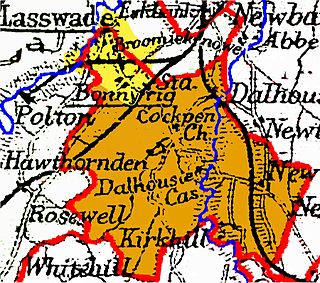
Cockpen is a parish in Midlothian, Scotland, containing at its north-west corner the town of Bonnyrigg, which lies two miles (3.2 km) south-west of Dalkeith. It is bounded on the west and north by the parish of Lasswade, on the east, by Newbattle and on the south by Carrington. It extends about three miles (4.8 km) from north to south and its greatest breadth is about 2+1⁄2 miles (4.0 km).

Scoonie is a settlement and parish in Fife, Scotland, the parish contains the town of Leven. It is bordered on the north by the parishes of Kettle and Ceres, on the east by the parish of Largo, on the south by the parishes of Markinch and Wemyss, and on the west by the parishes of Markinch and Kennoway. It extends about 4+1⁄2 miles north to south. Its width varies between 5⁄8 and 2+3⁄4 mi . The parish is on the coast of the Firth of Forth, with a coastline of about 1+1⁄2 mi (2.4 km) The area of the parish is 4,107 acres.
