Related Research Articles
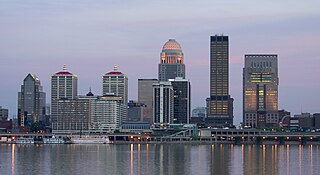
Louisville is the most populous city in the Commonwealth of Kentucky, sixth-most populous city in the Southeast, and the 27th-most-populous city in the United States. Louisville is the historical seat and, since 2003, the nominal seat of Jefferson County, on the Indiana border.

Shelby County is a county located in the U.S. state of Kentucky. As of the 2020 census, the population was 48,065. Its county seat is Shelbyville. The county was established in 1792 and named for Isaac Shelby, the first Governor of Kentucky. Shelby County is part of the Louisville/Jefferson County, KY–IN Metropolitan Statistical Area. Shelby County's motto is "Good Land, Good Living, Good People".

Spencer County is a county located in the U.S. state of Kentucky. As of the 2020 census, the total population was 19,490. Its county seat is Taylorsville. The county was founded in 1824 and named for Spier Spencer.

Oldham County is a county located in the north central part of the U.S. state and commonwealth of Kentucky. As of the 2020 census, the population was 67,607. Its county seat is La Grange. The county is named for Colonel William Oldham.

Jefferson County is located in the north central portion of the U.S. state of Kentucky. As of the 2020 census, the population was 782,969. It is the most populous county in the commonwealth.

Henry County is a county located in the north central portion of the U.S. state of Kentucky bordering the Kentucky River. As of the 2020 census, the population was 15,678. Its county seat is New Castle, but its largest city is Eminence. The county was founded in 1798 from portions of Shelby County. It was named for the statesman and governor of Virginia Patrick Henry. Henry County is included in the Louisville/Jefferson County, KY-IN Metropolitan Statistical Area. Since the 1990s, it has become an increasingly important exurb, especially as land prices have become higher in neighboring Oldham County. With regard to the sale of alcohol, it is classified as a wet county.
Fairdale is a former census-designated place in southern Jefferson County, Kentucky, United States. The population was 7,658 at the 2000 census. In 2003, the area was annexed to the city of Louisville due to a merger between the city and Jefferson County's unincorporated community. Fairdale is now a neighborhood within the city limits of Louisville. The ZIP Code for Fairdale is 40118.
It is within the boundaries of the Fairdale Fire Protection District which serves Fairdale and surrounding areas including the large Jefferson Memorial Forest and historic South Park Country Club, the oldest country club in the state of Kentucky.
Okolona is a former census-designated place (CDP) in southern Louisville/Jefferson County, Kentucky, United States. It is centered on the intersection of Preston Highway and the Outer Loop. The population was 17,807 at the 2000 census. When the government of Jefferson County merged with the city of Louisville, Kentucky in 2003, residents of Okolona also became citizens of Louisville Metro. As a result, Okolona is said to be a neighborhood within the city limits of Louisville.

Poplar Hills is a home rule-class city in Jefferson County, Kentucky, United States. It is a part of the Louisville Metro government, but operates as a city under the Mayor to Commissioner form of government. Per the 2020 census, the population was 380, but the city administration has made several annexation ordinances that have passed and awaits updated information. The current city population is estimated to be 2380. It currently has the highest population density for any city in Kentucky.
St. Dennis is a former census-designated place in western Jefferson County, Kentucky, United States. The population was 9,177 at the 2000 census. In 2003, the area was consolidated into the new Louisville Metro due to the merger of the Jefferson County and Louisville governments into one entity, thus St. Dennis remains as a unique neighborhood within Louisville.

St. Matthews is a city in Jefferson County, Kentucky, United States. It forms part of the Louisville Metro government but is separately incorporated as a home rule-class city. The population was 17,472 at the 2010 census, up from 15,852 at the 2000 census. It is the 23rd-largest city in the state. St. Matthews is one of the state's major shopping areas, home to the fifth-largest mall in Kentucky along with many smaller shopping centers along Shelbyville Road.
Valley Station is a former census-designated place in southwest Jefferson County, Kentucky, United States. The population was 22,946 at the 2000 census. When the government of Jefferson County merged with the city of Louisville, Kentucky in 2003, residents of Valley Station also became citizens of Louisville Metro. As a result, Valley Station is said to be a neighborhood within the city limits of Louisville by local media. It was named for its location in the valley between Muldraugh Hill and the Knobs.

Prospect is a home rule-class city in Jefferson and Oldham counties in the U.S. state of Kentucky. The Jefferson County portion is a part of the Louisville Metro government. The population was 4,698 at the time 2010 census. It is one of the wealthiest communities in Kentucky.
Nashville-Davidson (balance) is the name used by the U.S. Census Bureau to designate the portion of Davidson County, Tennessee, United States that does not include satellite cities of Nashville. Because Nashville and Davidson County share a consolidated metropolitan government, the parts of these cities that fall within Davidson County are considered part of Nashville, although they still retain their own municipal governments. The cities that are a part of Nashville-Davidson County, but are excluded from the balance are:

The Louisville metropolitan area is the 43rd largest metropolitan statistical area (MSA) in the United States. It had a population of 1,395,855 in 2020 according to the latest official census, and its principal city is Louisville, Kentucky.

Kentucky's 3rd congressional district is a congressional district in the U.S. state of Kentucky. It encompasses almost all of Louisville Metro, which, since the merger of 2003, is consolidated with Jefferson County, though other incorporated cities exist within the county, such as Shively and St. Matthews. The far eastern reaches of Louisville Metro are part of the 2nd congressional district.

Louisville is a city in Jefferson County, in the U.S. state of Kentucky. It is located at the Falls of the Ohio River.
This article includes information about the 100 most populous incorporated cities, the 100 most populous core-based statistical areas (CBSAs), and the 100 most populous primary statistical areas (PSAs) of the United States and Puerto Rico. This information is displayed in two tables. The first table ranks the cities, CBSAs, and PSAs separately by population. The second table displays the areas in hierarchical order by the most populous PSA, then most populous CBSA, and then most populous city.
References
- ↑ Jefferson County cities: An article from The Courier-Journal
- ↑ For what geographic areas does the Census Bureau produce estimates?
- 1 2 "2010 Demographic Profile Data, Louisville/Jefferson County metro government (balance), Kentucky". 2010 United States Census. United States Census Bureau. Archived from the original on May 21, 2019. Retrieved December 31, 2011.

38°09′59″N85°38′54″W / 38.16639°N 85.64833°W
| | This Louisville-related article is a stub. You can help Wikipedia by expanding it. |
| | This Jefferson County, Kentucky state location article is a stub. You can help Wikipedia by expanding it. |