M.T. Broyhill & Sons Corporation

Last updated
M.T. Boryhill and Sons Corp
Company typePrivate
Industry Real-estate
FounderM.T. Broyhill
Headquarters
United States
Area served
United States
Key people
M.T. Broyhill
Joel Broyhill
Marven Broyhill
Products Homes

M.T. Broyhill and Sons Corporation, also known as Broyhill and Sons, was a brick-and-mortar housing company based around Washington, D.C. Broyhill and Sons successfully capitalized on the post-World War II housing boom to become the largest builder of brick-and-mortar homes in the United States during the 1950s. By 1953, Broyhill and Sons was building 3,000 homes a year when the company also become the biggest customer of General Electric appliances. The company was owned by M.T. Broyhill, and sons Marvin Broyhill and Joel Broyhill whom become congressmen of Virginia for 11 terms, from 1953 to 1974. [1] [

Contents

History

Joel Broyhill, one of three founders of the company JoelBroyhill.jpg
Joel Broyhill, one of three founders of the company
The former M.T. Broyhill and Sons corporate headquarters at 4624 Lee Highway, in Arlington County, Virginia 2022-Aug-12-MT-Broyhill-4624-Lee-Hwy-Arlington-Virginia.jpg
The former M.T. Broyhill and Sons corporate headquarters at 4624 Lee Highway, in Arlington County, Virginia

Founder Marvin Broyhill was born on July 27, 1888 in Moravian Falls, North Carolina. He founded the company in 1915, originally in Hopewell, Virginia. [2] He married Nell Magdalene Broyhill (nee Brewer) in 1917. [3] The company built its first house in Northern Virginia, in 1934.

Sterling Park

Broyhill had long sought to develop a complete, self-contained satellite city. In the early 1960s, M.T. Broyhill and Sons entered into a partnership with U.S. Steel to develop 1,765 acres of farmland on either side of Route 7 into 3,500 houses, available in ten different models, 3,000 apartments, a 100 acre shopping center, a 75 acre recreation area, including an 18-hole gold course and a two acre lake, two elementary schools and a high school and a 547 acre industrial park, [4] to be named Sterling Park Aerospace Center. [5]

Part of the deal was that Sterling houses would be built with steel studs and siding, in order to promote of steel as a building material. The first phase of 1,000 houses were built with steel. After U.S. Steel withdrew from the deal, the remaining two phases of houses were built with lumber. [6]

Many first-generation residents worked either at the newly opened Dulles International Airport or the Federal Aviation Administration's Regional Air Traffic Control Center in Leesburg, Virginia. For many, the attraction was the lack of a home owners' association – the community instead being managed by the nonprofit Sterling Foundation. [6]

Founder retirement

In 1962, at the age of 73, after 47 years as the head of the company, M.T. Broyhill, Sr. retired and moved to Daytona Beach, Florida. His son, Marvin T. Broyhill, Jr. became the president, with cousin Tomas J. Broyhill as executive vice president and Representative Joel T. Broyhill one of the vice presidents. [2]

Houses

A typical house would feature an Interior Décor by Colony House and modern General Electric Kitchens in mix-or-match colors with dishwashers and metal cabinets. Prices increased during the life of the various subdivisions around Washington DC. Between 1979 and 2007, the Consumer Price Index increased by 2.8 times and the assessed value of a typical home increased by nearly 9 times, land by 15 times ($20,000 to $300,000 per quarter acre) and improvements by 5 to 10 times. All homes had air-conditioning. Air-conditioning was uncommon in homes of that price range at the time. Homeowners also have access to golf, tennis courts, and pools without membership fees. Broyhill's ideas, except for free golf, are realities today. [7]

Development

Notable projects include Sterling, Virginia where M.T. Broyhill and Sons built several thousand homes outside Dulles International Airport, and McLean, Virginia outside Washington D.C. The business strategy of Marvin Broyhill, Jr.'s was to put together a prefabricated home and sell it for about $17,000 less than a comparable Fairfax County Home.

21st century

M.T. Broyhill and Sons Corporation's work is visible in Northern Virginia, where Broyhill family remain active in regional real estate, and several Broyhill companies, including LR Broyhill Co. and Broyhill Enterprises, Inc., have continued to develop in and around Washington D.C..[ citation needed ]

Related Research Articles

<span class="mw-page-title-main">Dulles International Airport</span> Airport near Washington, D.C., US

Washington Dulles International Airport is an international airport in Loudoun County and Fairfax County in Northern Virginia, United States, 26 miles (42 km) west of downtown Washington, D.C.

<span class="mw-page-title-main">Fairfax County, Virginia</span> County in Virginia, United States

Fairfax County, officially the County of Fairfax, is a county in the Commonwealth of Virginia. With a population of 1,150,309 as of the 2020 census, it the most populous county in Virginia, the most populous jurisdiction in the Washington metropolitan area, and the most populous location in the Washington–Baltimore combined statistical area. The county seat is Fairfax; however, because it is an independent city under Virginia law, the city of Fairfax is not part of the county.

<span class="mw-page-title-main">Chantilly, Virginia</span> CDP in Virginia, United States

Chantilly is a census-designated place (CDP) in western Fairfax County, Virginia. The population was 24,301 as of the 2020 census. Chantilly is named after an early-19th-century mansion and farm, which in turn took the name of an 18th-century plantation that was located in Westmoreland County, Virginia. The name "Chantilly" originated in France with the Château de Chantilly, about 28 miles north of Paris.

<span class="mw-page-title-main">Pimmit Hills, Virginia</span> Census-designated place in Virginia, United States

Pimmit Hills is a census-designated place (CDP) in Fairfax County, Virginia, United States, a neighborhood within a densely populated urban area. The name derives from Pimmit Run, the stream that was named for John Pimmit.

<span class="mw-page-title-main">Tysons, Virginia</span> Census-designated place in Virginia, United States

Tysons, also known as Tysons Corner, is a census-designated place (CDP) in Fairfax County, Virginia, United States, spanning from the corner of SR 123 and SR 7. It is part of the Washington metropolitan area and located in Northern Virginia between McLean and Vienna along the I-495.

<span class="mw-page-title-main">Leesburg, Virginia</span> Town in Virginia, United States

Leesburg is a town in and the county seat of Loudoun County, Virginia, United States. Its is part of both the Northern Virginia region of the state and the Washington metropolitan area, including Washington, D.C., the nation's capital.Settlement in the area began around 1740, which is named for the Lee family, early leaders of the town. Located in the far northeast of the state, in the War of 1812 it was a refuge for important federal documents evacuated from Washington, DC, and in the Civil War, it changed hands several times.

<span class="mw-page-title-main">Mount Vernon</span> Plantation estate of George Washington

Mount Vernon is the former residence and plantation of George Washington, a Founding Father, commander of the Continental Army in the Revolutionary War, and the first president of the United States, and his wife, Martha. An American landmark, the estate lies on the banks of the Potomac River in Fairfax County, Virginia, approximately 15 miles south of Washington, D.C..

<span class="mw-page-title-main">Washington–Baltimore combined statistical area</span> Combined Statistical Area in the United States

The Washington–Baltimore combined metropolitan statistical area is a statistical area including the overlapping metropolitan areas of Washington, D.C. and Baltimore. The region includes Central Maryland, Northern Virginia, three counties in the Eastern Panhandle of West Virginia, and one county in south-central Pennsylvania. It is the most educated, highest-income, and third-most populous combined statistical area in the United States behind New York City–Newark, NJ and Los Angeles–Long Beach.

<span class="mw-page-title-main">Mount Pleasant (Washington, D.C.)</span> Neighborhood of Washington, D.C.

Mount Pleasant is a neighborhood in Washington, D.C., located in Northwest D.C. The neighborhood is primarily residential, with restaurants and stores centered along a commercial corridor on Mt. Pleasant Street. Mount Pleasant is known for its unique identity and multicultural landscape, home to diverse groups such as the punk rock, the Peace Corps and Hispanic Washingtonian communities.

<span class="mw-page-title-main">Sterling, Virginia</span> Census-designated place in Virginia

Sterling, Virginia, refers most specifically to a census-designated place (CDP) in Loudoun County, Virginia, United States. The population of the CDP as of the 2020 United States Census was 30,337 The CDP boundaries are confined to a relatively small area between Virginia State Route 28 on the west and Virginia State Route 7 on the northeast, excluding areas near SR 606 and the Dulles Town Center.

<span class="mw-page-title-main">Ashburn, Virginia</span> Census-designated place in Virginia, United States

Ashburn is a rapidly growing census-designated place (CDP) in Loudoun County, Virginia, United States. At the 2010 United States census, its population was 43,511, up from 3,393 in 1990. It is 30 miles (48 km) northwest of Washington, D.C., and part of the Washington metropolitan area.

<span class="mw-page-title-main">Silver Line (Washington Metro)</span> Washington Metro rapid transit line

The Silver Line is a rapid transit line of the Washington Metro system, consisting of 34 stations in Loudoun County, Fairfax County and Arlington County, Virginia, Washington, D.C., and Prince George's County, Maryland. The Silver Line runs from Ashburn in Virginia to Downtown Largo in Maryland. Five stations, from both lines' eastern terminus at Downtown Largo to Benning Road, are shared with the Blue Line alone; thirteen stations, from Stadium–Armory to Rosslyn, with both the Orange Line and Blue Lines; and five stations from Court House to East Falls Church with the Orange Line alone. Only the five stations of Phase 1, which began service on July 26, 2014, and the six stations of Phase 2, which began service on November 15, 2022, are exclusive to the Silver Line.

<span class="mw-page-title-main">Willard, Virginia</span> Unincorporated area in Virginia

Willard was an unincorporated community located in what is now a part of Washington Dulles International Airport in the U.S. state of Virginia.

<span class="mw-page-title-main">Joel Broyhill</span> American politician (1919–2006)

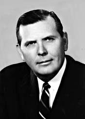
Joel Thomas Broyhill was an American politician aligned with the Republican Party who served as a Congressman from Virginia for 11 terms, from 1953 to 1974. He represented Virginia's 10th congressional district, consisting of suburbs of Arlington, Falls Church and sections of Fairfax County and Alexandria, and became known for his advocacy for federal workers as well as his opposition to integration in the 1950s and 1960s.

"America's Favorite Architecture" is a list of buildings and other structures identified as the most popular works of architecture in the United States.

<span class="mw-page-title-main">Sully Historic Site</span> Historic house in Virginia, United States

Sully Historic Site, is both a Virginia landmark and nationally registered historic place in Chantilly, Virginia.

<span class="mw-page-title-main">Abingdon (plantation)</span> Plantation site in Virginia, United States of America

Abingdon was an 18th- and 19th-century plantation owned by the prominent Alexander, Custis, Stuart, and Hunter families and worked at times by slaves. The plantation's site is now located in Arlington County in the U.S. state of Virginia.

Sugarland Run is a planned community and census-designated place in Loudoun County, Virginia, United States. The population at the 2010 census was 11,799. In 2020, it was estimated to be 12,956. Sugarland Run is part of the Washington metropolitan area and is 26 miles (42 km) by road northwest of Washington, D.C.

<span class="mw-page-title-main">Congressional Airport</span> Airport in Maryland, U.S.

Congressional Airport was a 40-acre (16 ha) airfield, located in what is now Rockville, Maryland, just outside Washington, D.C., used for the Civilian Pilot Training Program.

Broyhill may refer to:

References

  1. "Our Man in Arlington". Falls Church New-Press. 2013-01-30.
  2. 1 2 "Veteran Builder Broyhill Retires After 47 Years". Evening Star. Washington, D.C. 21 April 1962. p. B-5 via Chronicling America: Historic American Newspapers. Library of Congress.
  3. Broyhill III, Marvin T. "Marvin T. Broyhill (Sr.)". Broyhill Family History. Retrieved 13 August 2022.
  4. Poole, Daniel (28 July 1962). "The Birth of a City". Evening Star. Washington, D.C. pp. B-1, B-6 via Chronicling America: Historic American Newspapers. Library of Congress.
  5. "Land Values Rise in Airport Area". Evening Star. Washington, D.C. 11 November 1962. p. V-23 via Chronicling America: Historic American Newspapers. Library of Congress.
  6. 1 2 Dineley, Teddi (23 March 2002). "A Sterling Enclave As Sturdy as Steel". The Washington Post.
  7. "Broyhill McLean Estates History". Broyhill McLean Estates.