Bedfordshire

Totternhoe
Someries
Bedford
Yielden
Toddington
Tilsworth
Thurleigh
Risinghoe
Renhold
Podington
Old Warden
Odell
Higham Gobion
Flitwick
Etonbury
Eastcotts
Cainhoe
Chalgrave
Bletsoe
Biggleswade
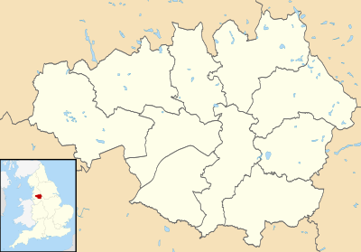
Castles in Bedfordshire
The castles displayed on each map are those listed in the List of castles in England for the corresponding county. Click on the red or green dot to display a detailed map showing the location of the castle. Green dots represent for the most part castles of which substantial remains survive, red dots represent castles of which only earthworks or vestiges survive, or in a few cases castles of which there are no visible remains.


Penrith is a market town and civil parish in the Westmorland and Furness district of Cumbria, England. It is less than 3 miles (5 km) outside the Lake District National Park and about 17 miles (27 km) south of Carlisle. It is between the Rivers Petteril and Eamont and just north of the River Lowther. The town had a population of 15,181 at the 2011 census. It is part of historic Cumberland.
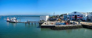
East Cowes is a town and civil parish in the north of the Isle of Wight, on the east bank of the River Medina, next to its west bank neighbour Cowes. It has a population of 8,428 according to the 2021 Census.

Baynard's Castle refers to buildings on two neighbouring sites in the City of London, between where Blackfriars station and St Paul's Cathedral now stand. The first was a Norman fortification constructed by Ralph Baynard, 1st feudal baron of Little Dunmow in Essex, and was demolished by King John in 1213. The second was a medieval palace built a short distance to the south-east and later extended, but mostly destroyed in the Great Fire of London in 1666. According to Sir Walter Besant, "There was no house in [London] more interesting than this".

Rougemont Castle, also known as Exeter Castle, is the historic castle of the city of Exeter, Devon, England. It was built into the northern corner of the Roman city walls starting in or shortly after the year 1068, following Exeter's rebellion against William the Conqueror. In 1136 it was besieged for three months by King Stephen. An outer bailey, of which little now remains, was added later in the 12th century.

East Harptree is a village and civil parish in Somerset, England. It is situated 5 miles (8.0 km) north of Wells and 15 miles (24.1 km) south of Bristol, on the northern slope of the Mendip Hills overlooking the Chew Valley. The parish has a population of 644. The parish includes the hamlet of Coley.
Montfichet's Tower was a Norman fortress on Ludgate Hill in London, between where St Paul's Cathedral and City Thameslink railway station now stand. First documented in the 1130s, it was probably built in the late 11th century. The defences were strengthened during the revolt of 1173–1174 against Henry II.

Brougham Castle is a medieval building about 2 miles (3.2 km) south-east of Penrith, Cumbria, England. The castle was founded by Robert I de Vieuxpont in the early 13th century. The site, near the confluence of the rivers Eamont and Lowther, had been chosen by the Romans for a Roman fort called Brocavum. The castle, along with the fort, is a scheduled monument: "Brougham Roman fort and Brougham Castle".

The River Chelmer flows entirely through the county of Essex, England; it runs 40 miles (64 km) from the north-west of the county through Chelmsford to the River Blackwater, near Maldon.
Little Dunmow is a village situated in the Uttlesford district, in rural Essex, England, in the vale of the River Chelmer about 3 miles (4.8 km) east-southeast of the town of Great Dunmow. It can be reached from the Dunmow South exit of the A120 by following the road towards Braintree (B1256) for 3.2 km before turning right for the village. The centre of the old village, which has just 99 dwellings, is a further 0.6 km along the road. The Flitch Way, a linear country park along the route of the old Braintree to Bishop's Stortford railway, links Little Dunmow and the new settlement of Flitch Green. The new village, built on the site of a former sugar beet factory, is a self-contained community of 850 dwellings and is another kilometre along the road towards Felsted.

East Cowes Castle, located in East Cowes, was the home of architect John Nash between its completion and his death in 1835. Nash himself was the designer of the site, and began construction as early as 1798. It was completed in 1800 and was said to have been built at unlimited expense. Nash was finally interred in the grounds.

Castle Baynard is one of the 25 wards of the City of London, the historic and financial centre of London, England.

Queenhithe is a small and ancient ward of the City of London, situated by the River Thames and to the south of St. Paul's Cathedral. The Millennium Bridge crosses into the City at Queenhithe.
The castles displayed on each map are those listed in the List of castles in England for the corresponding county. Click on the red or green dot to display a detailed map showing the location of the castle. Green dots represent for the most part castles of which substantial remains survive, red dots represent castles of which only earthworks or vestiges survive, or in a few cases castles of which there are no visible remains.