The British Virgin Islands are located in the Caribbean, between the Caribbean Sea and the North Atlantic Ocean, east of Puerto Rico.Its geographic coordinates are 18°30′N64°30′W. Map references include Central America and the Caribbean. The area totals 151 km² and comprises 16 inhabited and more than 20 uninhabited islands; includes the islands of Tortola, Anegada, Virgin Gorda and Jost van Dyke. There are no bodies of water on the land. There are no land boundaries. There is 80 km of coastline. Maritime claims include 3 nmi of territorial sea and exclusive a 200 nmi fishing zone. It has a tropical, humid climate, with temperatures moderated by trade winds. Its terrain consists of coral islands, and is relatively flat. It has volcanic islands and is steep and hilly. Its lowest point is the Caribbean Sea and its highest point is Mount Sage at 521 metres (1,709 ft) above sea level. Its natural resources are negligible. In terms of land use, it is 20% arable land, 6.67% permanent crops and 73.33% other as of a 2005 figure. Its natural hazards consist of hurricanes and tropical storms from July to October. There is limited natural fresh water resources. It has strong ties to nearby U.S. Virgin Islands and Puerto Rico.

Primera is a town in Cameron County, Texas, United States, near Combes. The population was 4,070 at the 2010 census. It is part of the Brownsville–Harlingen–Raymondville and the Matamoros–Brownsville metropolitan areas.

Salisbury is a borough in Somerset County, Pennsylvania, United States. The population was 878 at the 2000 census. It is part of the Johnstown, Pennsylvania Metropolitan Statistical Area.

Ghent is a census-designated place (CDP) in the town of Ghent in Columbia County, New York, United States. The population of the CDP was 564 at the 2010 census, out of a total town population of 5,402.

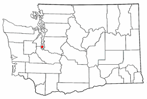
Raft Island is a private island and CDP located near the Pierce County community of Rosedale, Washington, United States. Gig Harbor, Washington is the nearest incorporated town, although unincorporated Artondale is much closer. The island features approximately 200 homes on 160 acres. All of these homes are served through the Gig Harbor post office.

Cruz Bay, U.S. Virgin Islands is the main town on the island of Saint John in the United States Virgin Islands. According to the 2000 census, Cruz Bay had a population of 2,743.
The area code (340) is the local telephone area code of U.S. Virgin Islands. The (340) area code was created during a split from the original (809) area code, which began permissive dialing on 1 June 1997 and ended 30 June 1998.
Featherstone Fork is an unincorporated community in Caroline County, in the U.S. state of Virginia.
Fish Bay is a bay and neighborhood on the island of Saint John in the United States Virgin Islands. Most of this area is part of Virgin Islands National Park.
L'Esperance is a former plantation on the island of Saint John in the United States Virgin Islands. It is uninhabited and part of Virgin Islands National Park. The L'Esperance trail is maintained by the National Park Service.
Sieben is a former plantation on the island of Saint John in the United States Virgin Islands. Homes in this area are considered by the local government to be located in Remainder Fish Bay. The Sieben plantation ruins are accessible via the L'Esperance Trail. Most of this area is part of Virgin Islands National Park. The only baobab tree on St. John is near the Sieben ruins.

North Side is a settlement on the island of Saint Croix in the United States Virgin Islands.
Ruby is a settlement on the island of Saint Croix in the United States Virgin Islands.
Teagues Bay is a settlement on the island of Saint Croix in the United States Virgin Islands.
Union Hill is an unincorporated community in Buckingham County, in the U.S. state of Virginia.
Corn Island is a forested island of Essex County, Massachusetts.
Pinnickinnick Mountain is a summit in West Virginia, in the United States. With an elevation of 1,453 feet (443 m), Pinnickinnick Mountain is the 774th highest summit in the state of West Virginia.


