
The Oregon Trail is a 2,170-mile (3,490 km) historic East–West, large-wheeled wagon route and emigrant trail in the United States that connected the Missouri River to valleys in Oregon. The eastern part of the Oregon Trail spanned part of the future state of Kansas, and nearly all of what are now the states of Nebraska and Wyoming. The western half of the trail spanned most of the future states of Idaho and Oregon.

Cheyenne County is the sixth-least densely populated of the 64 counties of the U.S. state of Colorado. The county population was 1,836 at 2010 census. The county seat is Cheyenne Wells.
The East Coast Greenway is a 3,000-mile (4,800 km) biking and walking route linking the major cities of the Atlantic coast of the United States, from Calais, Maine, to Key West, Florida. The spine route and branching complementary routes are for non-motorized human transportation for everything from local commutes to long-distance trips.

The North Platte River is a major tributary of the Platte River and is approximately 716 miles (1,152 km) long, counting its many curves. In a straight line, it travels about 550 miles (890 km), along its course through the U.S. states of Colorado, Wyoming, and Nebraska.

The Rock River is a tributary of the Mississippi River, approximately 299 miles (481 km) long, in the U.S. states of Wisconsin and Illinois. The river was known as the Sinnissippi to Sauk and Fox Indians; the name means "rocky waters".

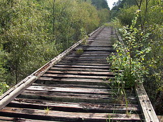
The Kal-Haven Trail, formally known as the Kal-Haven Trail Sesquicentennial State Park, is a rail trail that originally ran 33.5 miles (55 km) between South Haven, Michigan, to a point just west of the city of Kalamazoo, Michigan, where there is a trailhead. In 2008 the trail was extended east from the trailhead to downtown Kalamazoo as part of the Kalamazoo River Valley Trail.
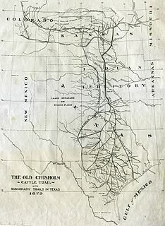
The Chisholm Trail was a trail used in the post-Civil War era to drive cattle overland from ranches in Texas to Kansas railheads. The trail was established by Delaware scout and cattle rancher Black Beaver and his friend Jesse Chisholm who was a merchant. The southern terminus was a trading post near the Red River, and the Northern terminus was a trading post near Kansas City, Kansas. Both trading posts were owned by Chisholm.
The Potomac Heritage Trail, also known as the Potomac Heritage National Scenic Trail or the PHT, is a designated National Scenic Trail corridor spanning parts of the mid-Atlantic and upper southeastern regions of the United States that will connect various trails and historic sites in the states of Virginia, Maryland, and Pennsylvania and the District of Columbia. The trail network includes 710 miles (1,140 km) of existing and planned sections, tracing the outstanding natural, historical, and cultural features of the Potomac River corridor, the upper Ohio River watershed in Pennsylvania and western Maryland, and a portion of the Rappahannock River watershed in Virginia. The trail is managed by the National Park Service.
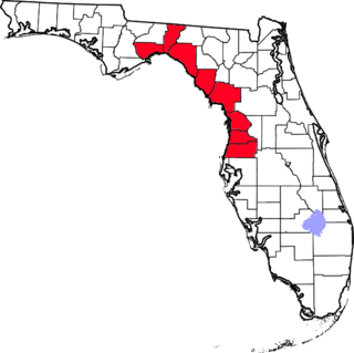
The Nature Coast is an informal, unofficial region of the U.S. state of Florida. The broadest definition of the Nature Coast includes the eight counties that abut the Gulf of Mexico along the Big Bend Coast defined by geologists: from west to east, Wakulla, Jefferson, Taylor, Dixie, Levy, Citrus, Hernando, and Pasco counties.

Three Rivers Park District is a special park district serving the suburban areas of the Twin Cities including suburban Hennepin, Carver, Dakota, Scott and Ramsey counties. Three Rivers's mission is "To promote environmental stewardship through recreation and education in a natural resources-based park system." Three Rivers operates twenty parks and ten regional trails, with at least two more regional trails planned. Nearly seven million people visit Three Rivers facilities each year.

Beacon Mountain, locally Mount Beacon, is the highest peak of Hudson Highlands, located behind the City of Beacon, New York, in the Town of Fishkill. Its two summits rise above the Hudson River behind the city and can easily be seen from Newburgh across the river and many other places in the region. The more accessible northern peak, at 1,531 feet above sea level, has a complex of radio antennas on its summit; the 1,610-foot southern summit has a fire lookout tower.
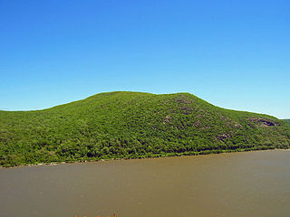
Bull Hill, also known as Mount Taurus, is a mountain north of the village of Cold Spring on the Hudson River in Putnam County in the State of New York. It is part of the river-straddling range known as the Hudson Highlands. The original name came after a bull that used to terrorize the mountain was chased by indignant inhabitants. A hunting party drove the bull over the hill. In an attempt to flee the mountaineers, the bull plunged out into space and fell down. Its broken and shapeless mass on the rocks was memorialized in the name of the mountain the bull used to haunt.

The Schuylkill River Trail is a multi-use trail along the banks of the Schuylkill River in southeastern Pennsylvania. Partially complete as of 2018, the trail is ultimately planned to run about 140 miles (230 km) from the river's headwaters in Schuylkill County to Fort Mifflin in Philadelphia.

Difficult Run is a 15.9-mile-long (25.6 km) tributary stream of the Potomac River in Northern Virginia in the United States. The area has had many historical uses dating back to the early 1800s. Today, the area is used recreationally by visitors interested in the watershed's variety of options including hiking, biking, fishing, boating, climbing, and bird watching. The wildlife at Difficult Run is vast as 163 different species can be seen depending on the season. There are 41 different soil types found on the trail and alongside the stream. The stream is part of the greater 57.7- square-mile Drainage basin, or watershed, located in the north-central portion of Fairfax County and drains directly to the Potomac River.

The Spokane River Centennial Trail is a 37-mile (60 km) paved trail in Eastern Washington for alternate transportation and recreational use. It is managed by Washington State Parks as the Spokane River Centennial State Park Trail.

The Three Rivers Heritage Trail is an urban rail-trail paralleling the riverbanks in Pittsburgh, Pennsylvania for about 25 miles (40 km), often on both sides of the rivers, and offering views of the city. The trail is promoted and maintained in part by the 'Friends of the Riverfront'. Their stated mission is to increase awareness and engagement with the region’s rivers and riverfronts through activities and stewardship, and to extend the water and land trails on the major rivers within Allegheny County.
New River is a 31-mile-long (50 km) tributary of the Santa Fe River in northern Florida, United States. The river was used as the border to create Union County from Bradford County in 1921.

The Ohio River Trail (ORT) is composed of two entities, the Ohio River Water Trail and the Ohio River Greenway Trail. The Ohio River Greenway Trail is a proposed route that would interconnect existing trails in Maryland, Pennsylvania, Ohio and West Virginia. The proposal is spearheaded by the Ohio River Trail Council (ORTC), a volunteer-led, non-profit organization. The ORTC is an Internal Revenue Service registered 501(c)(3) not-for-profit organization which relies on corporate, foundation, government, and private grants and donations to achieve its stated mission of creating a multi-use trail along the Ohio River and its tributaries. The Council is headquartered in Monaca, Pennsylvania.
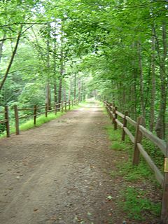
The Aspetuck Valley Trail is a 5.9-mile (9.5 km) Blue-Blazed hiking trail in the Aspetuck River Valley area of Fairfield County in the towns of Newtown, Easton and Redding Connecticut.


