The Resource Description Framework (RDF) is a World Wide Web Consortium (W3C) standard originally designed as a data model for metadata. It has come to be used as a general method for description and exchange of graph data. RDF provides a variety of syntax notations and data serialization formats, with Turtle currently being the most widely used notation.
XSD, a recommendation of the World Wide Web Consortium (W3C), specifies how to formally describe the elements in an Extensible Markup Language (XML) document. It can be used by programmers to verify each piece of item content in a document, to assure it adheres to the description of the element it is placed in.

The Geography Markup Language (GML) is the XML grammar defined by the Open Geospatial Consortium (OGC) to express geographical features. GML serves as a modeling language for geographic systems as well as an open interchange format for geographic transactions on the Internet. Key to GML's utility is its ability to integrate all forms of geographic information, including not only conventional "vector" or discrete objects, but coverages and sensor data.

A bus stop is a place where buses stop for passengers to get on and off the bus. The construction of bus stops tends to reflect the level of usage, where stops at busy locations may have shelters, seating, and possibly electronic passenger information systems; less busy stops may use a simple pole and flag to mark the location. Bus stops are, in some locations, clustered together into transport hubs allowing interchange between routes from nearby stops and with other public transport modes to maximise convenience.
SPARQL is an RDF query language—that is, a semantic query language for databases—able to retrieve and manipulate data stored in Resource Description Framework (RDF) format. It was made a standard by the RDF Data Access Working Group (DAWG) of the World Wide Web Consortium, and is recognized as one of the key technologies of the semantic web. On 15 January 2008, SPARQL 1.0 was acknowledged by W3C as an official recommendation, and SPARQL 1.1 in March, 2013.
The shapefile format is a geospatial vector data format for geographic information system (GIS) software. It is developed and regulated by Esri as a mostly open specification for data interoperability among Esri and other GIS software products. The shapefile format can spatially describe vector features: points, lines, and polygons, representing, for example, water wells, rivers, and lakes. Each item usually has attributes that describe it, such as name or temperature.
The Verkehrsverbund Rhein-Ruhr, abbreviated VRR, is a public transport association (Verkehrsverbund) in the German state of North Rhine-Westphalia. It covers most of the Ruhr area, as well as neighbouring parts of the Lower Rhine region, including Düsseldorf and thus large parts of the Rhine-Ruhr conurbation. It was founded on 1 January 1980, and is Europe’s largest body of such kind, covering an area of some 5,000 km2 (1,900 sq mi) with more than 7.8 million inhabitants, spanning as far as Dorsten in the north, Dortmund in the east, Langenfeld in the south, and Mönchengladbach and the Dutch border in the west.

The Transport Direct Programme was a division of the UK Department for Transport (DfT) to develop standards, data and better information technology systems to support public transport. It developed and operates the Transport Direct Portal which is a public facing multi-modal journey planner. It also supports the creation and management of comprehensive databases of all public transport movements in the United Kingdom with Traveline. During 2010 two key datasets were released as Open Data and published on www.data.gov.uk.
The National Public Transport Gazetteer (NPTG) provides a topographic database of towns and settlements in the UK; it provides a common frame of reference for the National Public Transport Access Nodes (NaPTAN) schema and other UK Public Transport Information schemas such as JourneyWeb.
TransXChange is a UK national XML based data standard for the interchange of bus route and timetable information between bus operators, the Vehicle and Operator Services Agency, local authorities and passenger transport executives, and others involved in the provision of passenger information.
The Standard Interface for Real-time Information or SIRI is an XML protocol to allow distributed computers to exchange real-time information about public transport services and vehicles.
Transmodel, also known as Reference Data Model For Public Transport , is a European Standard for modelling and exchanging public transport information. It provides a standard data model and specialised data structures to uniformly represent common public transport concepts, facilitating the use of data in a wide variety of public transport information systems, including for timetabling, fares, operational management, real-time data, and journey planning.
IFOPT is a CEN Technical Specification that provides a Reference Data Model for describing the main fixed objects required for public access to Public transport, that is to say Transportation hubs. Such a model is a fundamental component of the modern Public transport information systems needed both to operate Public transport and to inform passengers about services. IFOPT has been revised and incorporated into Transmodel v6 – Part 2. .
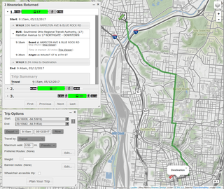
A journey planner, trip planner, or route planner is a specialized search engine used to find an optimal means of travelling between two or more given locations, sometimes using more than one transport mode. Searches may be optimized on different criteria, for example fastest, shortest, fewest changes, cheapest. They may be constrained, for example, to leave or arrive at a certain time, to avoid certain waypoints, etc. A single journey may use a sequence of several modes of transport, meaning the system may know about public transport services as well as transport networks for private transportation. Trip planning or journey planning is sometimes distinguished from route planning, which is typically thought of as using private modes of transportation such as cycling, driving, or walking, normally using a single mode at a time. Trip or journey planning, in contrast, would make use of at least one public transport mode which operates according to published schedules; given that public transport services only depart at specific times, an algorithm must therefore not only find a path to a destination, but seek to optimize it so as to minimize the waiting time incurred for each leg. In European Standards such as Transmodel, trip planning is used specifically to describe the planning of a route for a passenger, to avoid confusion with the completely separate process of planning the operational journeys to be made by public transport vehicles on which such trips are made.
A Formal Public Identifier (FPI) is a short piece of text with a particular structure that may be used to uniquely identify a product, specification or document. FPIs were introduced as part of Standard Generalized Markup Language (SGML), and serve particular purposes in formats historically derived from SGML. Some of their most common uses are as part of document type declarations (DOCTYPEs) and document type definitions (DTDs) in SGML, XML and historically HTML, but they are also used in the vCard and iCalendar file formats to identify the software product which generated the file.
A file format is a standard way that information is encoded for storage in a computer file. It specifies how bits are used to encode information in a digital storage medium. File formats may be either proprietary or free.
CycleNetXChange provides a standard format with which to exchange cycle path data, together with information about the quality of routes; This enables computerised transport systems to provide cycle routes.

Traveline is a public transport route planner service provided by a partnership between local authorities and transport operators in the UK to provide impartial and comprehensive information about public transport which has operated since 2000. It prepares comprehensive public transport data for the UK and provides a number of regional public transport journey planners.
NeTEx is the CEN Technical standard for exchanging Public Transport Information as XML documents. It provides a W3C XML schema based on the Transmodel abstract model of common public transport concepts and data structures and can be used to exchange many different kinds of data between passenger information systems, including data describing for stops, facilities, timetabling and fares. Such data can be used by both operational management systems and customer facing systems for journey planning etc.
Bustimes.org is a transportation information website created to take advantage of Bus Services Act 2017 requirement for bus operators in England to provide bus timetables, fares and vehicle locations in an open data format, which can be utilised by app and website developers. This DfT service is called the Bus Open Data Service.
