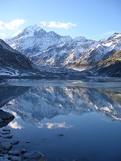
Aoraki / Mount Cook is the highest mountain in New Zealand. Its height, as of 2014, is listed as 3,724 metres. It lies in the Southern Alps / Kā Tiritiri o te Moana, the mountain range which runs the length of the South Island. A popular tourist destination, it is also a favourite challenge for mountain climbers. Aoraki / Mount Cook consists of three summits: from south to north, the Low Peak, the Middle Peak and the High Peak. The summits lie slightly south and east of the main divide of the Southern Alps / Kā Tiritiri o te Moana, with the Tasman Glacier to the east and the Hooker Glacier to the southwest.
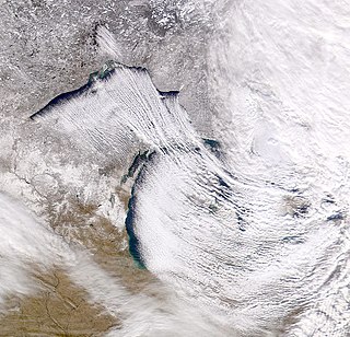
Lake-effect snow is produced during cooler atmospheric conditions when a cold air mass moves across long expanses of warmer lake water. The lower layer of air, heated up by the lake water, picks up water vapor from the lake and rises up through the colder air above; the vapor then freezes and is deposited on the leeward (downwind) shores.

Fog is a visible aerosol consisting of tiny water droplets or ice crystals suspended in the air at or near the Earth's surface. Fog can be considered a type of low-lying cloud usually resembling stratus, and is heavily influenced by nearby bodies of water, topography, and wind conditions. In turn, fog has affected many human activities, such as shipping, travel, and warfare.

Otago is a region of New Zealand located in the southern half of the South Island administered by the Otago Regional Council. It has an area of approximately 32,000 square kilometres (12,000 sq mi), making it the country's second largest local government region. Its population was 245,300 in June 2020.
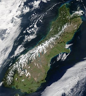
The Southern Alps is a mountain range extending along much of the length of New Zealand's South Island, reaching its greatest elevations near the range's western side. The name "Southern Alps" generally refers to the entire range, although separate names are given to many of the smaller ranges that form part of it.

The mistral is a strong, cold, northwesterly wind that blows from southern France into the Gulf of Lion in the northern Mediterranean. It produces sustained winds often exceeding 66 km/h (41 mph) / 18 m/s (36 kn), sometimes reaching 185 km/h (115 mph) / 51 m/s (100 kn). It is most common in the winter and spring, and strongest in the transition between the two seasons. Periods of the wind exceeding 30 km/h (19 mph) / 8 m/s (16 kn) for more than sixty-five hours have been reported.

A föhn, also spelled foehn is a type of dry, warm, down-slope wind that occurs in the lee of a mountain range.

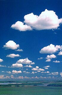
Orographic lift occurs when an air mass is forced from a low elevation to a higher elevation as it moves over rising terrain. As the air mass gains altitude it quickly cools down adiabatically, which can raise the relative humidity to 100% and create clouds and, under the right conditions, precipitation.

A rain shadow is a dry area on the leeward side of a mountainous area. The mountains block the passage of rain-producing weather systems and cast a "shadow" of dryness behind them. Wind and moist air are drawn by the prevailing winds towards the top of the mountains, where it condenses and precipitates before it crosses the top. The air, without much moisture left, advances across the mountains creating a drier side called the "rain shadow".
A sea breeze or onshore breeze is any wind that blows from a large body of water toward or onto a landmass; it develops due to differences in air pressure created by the differing heat capacities of water and dry land. As such, sea breezes are more localised than prevailing winds. Because land absorbs solar radiation far more quickly than water, a sea breeze is a common occurrence along coasts after sunrise. By contrast, a land breeze or offshore breeze is the reverse effect: dry land also cools more quickly than water and, after sunset, a sea breeze dissipates and the wind instead flows from the land towards the sea. Sea breezes and land breezes are both important factors in coastal regions' prevailing winds. The term offshore wind may refer to any wind over open water.

Chinook winds, or simply Chinooks, are föhn winds in the interior West of North America, where the Canadian Prairies and Great Plains meet various mountain ranges, although the original usage is in reference to wet, warm coastal winds in the Pacific Northwest.
Weather lore is the body of informal folklore related to the prediction of the weather and its greater meaning.
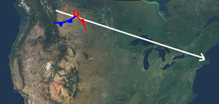
An Alberta clipper, also known as a Canadian clipper, is a fast moving low pressure area weather system which generally affects the central provinces of Canada and parts of the Upper Midwest, Great Lakes, and New England, precipitating a sudden temperature drop and sharp winds. Alberta clippers take their name from Alberta, the province from which they appear to descend, and from clipper ships of the 19th century, one of the fastest ships of that time.

A weather front is a boundary separating air masses of several characteristics such as air density, wind, and humidity. Disturbed weather often arises from these differences. For instance, cold fronts can bring bands of thunderstorms or be preceded by squall lines, while warm fronts are usually preceded by stratiform precipitation and fog. In summer, subtler humidity gradients known as or dry lines can trigger severe weather. Some fronts produce no precipitation and little cloudiness, although there is invariably a wind shift.

Berg wind is the South African name for a katabatic wind: a hot dry wind blowing down the Great Escarpment from the high central plateau to the coast.

Cold air damming, or CAD, is a meteorological phenomenon that involves a high-pressure system (anticyclone) accelerating equatorward east of a north-south oriented mountain range due to the formation of a barrier jet behind a cold front associated with the poleward portion of a split upper level trough. Initially, a high-pressure system moves poleward of a north-south mountain range. Once it sloshes over poleward and eastward of the range, the flow around the high banks up against the mountains, forming a barrier jet which funnels cool air down a stretch of land east of the mountains. The higher the mountain chain, the deeper the cold air mass becomes lodged to its east, and the greater impediment it is within the flow pattern and the more resistant it becomes to intrusions of milder air.

A cold front is the leading edge of a cooler mass of air at ground level that replaces a warmer mass of air and lies within a pronounced surface trough of low pressure. It often forms behind an extratropical cyclone, at the leading edge of its cold air advection pattern—known as the cyclone's dry "conveyor belt" flow. Temperature differences across the boundary can exceed 30 °C (86 °F) from one side to the other. When enough moisture is present, rain can occur along the boundary. If there is significant instability along the boundary, a narrow line of thunderstorms can form along the frontal zone. If instability is weak, a broad shield of rain can move in behind the front, and evaporative cooling of the rain can increase the temperature difference across the front. Cold fronts are stronger in the fall and spring transition seasons and weakest during the summer.
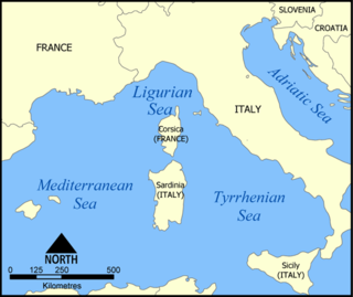
A Genoa low is a cyclone that forms or intensifies from a pre-existing cyclone to the south of the Alps over the Gulf of Genoa, Ligurian Sea, Po Valley and northern Adriatic. Vb cyclones are rare events which occur on average only 2.3 times per year.

This glossary of meteorology is a list of terms and concepts relevant to meteorology and atmospheric science, their sub-disciplines, and related fields.


