
Apus is a small constellation in the southern sky. It represents a bird-of-paradise, and its name means "without feet" in Greek because the bird-of-paradise was once wrongly believed to lack feet. First depicted on a celestial globe by Petrus Plancius in 1598, it was charted on a star atlas by Johann Bayer in his 1603 Uranometria. The French explorer and astronomer Nicolas Louis de Lacaille charted and gave the brighter stars their Bayer designations in 1756.

A constellation is an area on the celestial sphere in which a group of visible stars forms a perceived pattern or outline, typically representing an animal, mythological subject, or inanimate object.
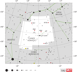
Canes Venatici is one of the 88 constellations designated by the International Astronomical Union (IAU). It is a small northern constellation that was created by Johannes Hevelius in the 17th century. Its name is Latin for 'hunting dogs', and the constellation is often depicted in illustrations as representing the dogs of Boötes the Herdsman, a neighboring constellation.

Dorado is a constellation in the Southern Sky. It was named in the late 16th century and is now one of the 88 modern constellations. Its name refers to the mahi-mahi, which is known as dorado ("golden") in Spanish, although it has also been depicted as a swordfish. Dorado contains most of the Large Magellanic Cloud, the remainder being in the constellation Mensa. The South Ecliptic pole also lies within this constellation.

Hydrus is a small constellation in the deep southern sky. It was one of twelve constellations created by Petrus Plancius from the observations of Pieter Dirkszoon Keyser and Frederick de Houtman and it first appeared on a 35-cm (14 in) diameter celestial globe published in late 1597 in Amsterdam by Plancius and Jodocus Hondius. The first depiction of this constellation in a celestial atlas was in Johann Bayer's Uranometria of 1603. The French explorer and astronomer Nicolas Louis de Lacaille charted the brighter stars and gave their Bayer designations in 1756. Its name means "male water snake", as opposed to Hydra, a much larger constellation that represents a female water snake. It remains below the horizon for most Northern Hemisphere observers.

Lupus is a constellation of the mid-Southern Sky. Its name is Latin for wolf. Lupus was one of the 48 constellations listed by the 2nd-century astronomer Ptolemy, and it remains one of the 88 modern constellations but was long an asterism associated with the just westerly, larger constellation Centaurus.

Microscopium is a minor constellation in the southern celestial hemisphere, one of twelve created in the 18th century by French astronomer Nicolas-Louis de Lacaille and one of several depicting scientific instruments. The name is a Latinised form of the Greek word for microscope. Its stars are faint and hardly visible from most of the non-tropical Northern Hemisphere.

Octans is a faint constellation located in the deep Southern Sky. Its name is Latin for the eighth part of a circle, but it is named after the octant, a navigational instrument. Devised by French astronomer Nicolas Louis de Lacaille in 1752, Octans remains one of the 88 modern constellations. The southern celestial pole is located within the boundaries of Octans.

A star catalogue is an astronomical catalogue that lists stars. In astronomy, many stars are referred to simply by catalogue numbers. There are a great many different star catalogues which have been produced for different purposes over the years, and this article covers only some of the more frequently quoted ones. Star catalogues were compiled by many different ancient people, including the Babylonians, Greeks, Chinese, Persians, and Arabs. They were sometimes accompanied by a star chart for illustration. Most modern catalogues are available in electronic format and can be freely downloaded from space agencies' data centres. The largest is being compiled from the spacecraft Gaia and thus far has over a billion stars.

Sculptor is a faint constellation in the southern sky. It represents a sculptor. It was introduced by Nicolas Louis de Lacaille in the 18th century. He originally named it Apparatus Sculptoris, but the name was later shortened.
In observational astronomy, culmination is the passage of a celestial object across the observer's local meridian. These events were also known as meridian transits, used in timekeeping and navigation, and measured precisely using a transit telescope.

Reticulum is a small, faint constellation in the southern sky. Its name is Latin for a small net, or reticle—a net of crosshairs at the focus of a telescope eyepiece that is used to measure star positions. The constellation is best viewed between October and December, and save for one main star visible in ideal conditions, cannot be seen from north of the 30th parallel north.

In contemporary astronomy, 88 constellations are recognized by the International Astronomical Union (IAU). Each constellation is a region of the sky bordered by arcs of right ascension and declination, together covering the entire celestial sphere. Their boundaries were officially adopted by the International Astronomical Union in 1928 and published in 1930.

Petrus Plancius was a Dutch-Flemish astronomer, cartographer and clergyman. He was born as Pieter Platevoet in Dranouter, now in Heuvelland, West Flanders. He studied theology in Germany and England. At the age of 24 he became a minister in the Dutch Reformed Church.

A star chart is a celestial map of the night sky with astronomical objects laid out on a grid system. They are used to identify and locate constellations, stars, nebulae, galaxies, and planets. They have been used for human navigation since time immemorial. Note that a star chart differs from an astronomical catalog, which is a listing or tabulation of astronomical objects for a particular purpose. Tools using a star chart include the astrolabe and planisphere.

Former constellations are old historical Western constellations that for various reasons are no longer widely recognised or are not officially recognised by the International Astronomical Union (IAU). Prior to 1930, many of these defunct constellations were traditional in one or more countries or cultures. Some only lasted decades but others were referred to over many centuries. All are now recognised only for having classical or historical value. Many former constellations had complex Latinised names after objects, people, or mythological or zoological creatures. Others with unwieldy names were shortened for convenience. For example, Scutum Sobiescianum was reduced to Scutum, Mons Mensae to Mensa, and Apparatus Sculptoris to Sculptor.
In astronomy, Durchmusterung or Bonner Durchmusterung (BD) is an astrometric star catalogue of the whole sky, published by the Bonn Observatory in Germany from 1859 to 1863, with an extension published in Bonn in 1886. The name comes from Durchmusterung, a German word used for a systematic survey of objects or data. The term has sometimes been used for other astronomical surveys, including not only stars, but also the search for other celestial objects. Special tasks include celestial scanning in electromagnetic wavelengths shorter or longer than visible light waves.

Celestial cartography, uranography, astrography or star cartography is the aspect of astronomy and branch of cartography concerned with mapping stars, galaxies, and other astronomical objects on the celestial sphere. Measuring the position and light of charted objects requires a variety of instruments and techniques. These techniques have developed from angle measurements with quadrants and the unaided eye, through sextants combined with lenses for light magnification, up to current methods which include computer-automated space telescopes. Uranographers have historically produced planetary position tables, star tables, and star maps for use by both amateur and professional astronomers. More recently, computerized star maps have been compiled, and automated positioning of telescopes uses databases of stars and of other astronomical objects.
The Skalnaté Pleso Atlas of the Heavens is a set of 16 celestial charts covering the entire sky. It is named after the Skalnaté Pleso Observatory in Slovakia where it was produced. The first versions were published by the Czechoslovak Astronomical Society in 1948; later that year, Sky Publishing Corporation acquired the copyright and began publication in the United States. The charts were hand-drawn by Antonín Bečvář.

A Celestial Atlas, full title: A Celestial Atlas: Comprising A Systematic Display of the Heavens in a Series of Thirty Maps Illustrated by Scientific Description of their Contents, And accompanied by Catalogues of the Stars and Astronomical Exercises is a star atlas by British author Alexander Jamieson, published in 1822. The atlas includes 30 plates, 26 of which are constellation maps with a sinusoidal projection. In some editions the plates are hand-colored. The atlas includes three new constellations invented by Jamieson: Noctua, Norma Nilotica, and Solarium. Two celestial hemispheres of the atlas are centered on the equatorial poles via polar projection and geocentric alignment. The atlas comprises stars visible only to the naked eye, making it less cluttered.