
Sussex County is the northernmost county in the State of New Jersey. Its county seat is Newton. It is part of the New York metropolitan area and is part of New Jersey's Skylands Region. As of the 2020 U.S. census, the county's population was enumerated at 144,221, making it the 17th-most populous of the state's 21 counties, and representing a decrease of 5,044 (3.4%) from the 149,265 counted at the 2010 U.S. census, in turn an increase of 5,099 (3.5%) over the 144,166 persons at the 2000 census. Based on 2010 census data, Vernon Township was the county's largest in both population and area, with a population of 23,943 and covering an area of 70.59 square miles (182.8 km2).

Sparta is a township in Sussex County, New Jersey, United States. As of the 2020 United States Census, the population was 19,600, reflecting a decrease of 122 (−0.6%) from the 2010 United States Census, when the township's population was 19,722, which in turn reflected an increase of 1,642 (+9.1%) from the 18,080 counted in the 2000 Census.

Route 181 is a 7.47-mile (12.02 km) state highway in Jefferson Township and Sparta Township in New Jersey. The highway begins in Jefferson Township at a cloverleaf interchange with Route 15 and Espanong Road. Route 181 serves as the local route through Woodport, serving the eastern shores of Lake Hopatcong as well as the main road through the center of Sparta. The route terminates at a jughandle with Route 15 in Sparta.

Lake Hopatcong is the largest freshwater body in New Jersey, United States, about 4 square miles (10 km2) in area. Located 30 miles (48 km) from the Delaware River and 40 miles (64 km) from Manhattan, New York City, the lake forms part of the border between Sussex and Morris counties in the state's northern highlands region. Lake Hopatcong was produced by damming and flooding of two ponds, known as the Great Pond and Little Pond, and the Musconetcong River, its natural outlet. Historically known as a resort lake for vacationing New Yorkers, it is now a mostly suburban residential lake.
The Morris Canal (1829–1924) was a 107-mile (172 km) common carrier anthracite coal canal across northern New Jersey that connected the two industrial canals at Easton, Pennsylvania, across the Delaware River from its western terminus at Phillipsburg, New Jersey to New York Harbor and New York City via its eastern terminals in Newark and on the Hudson River in Jersey City. The canal was sometimes called the Morris and Essex Canal, in error, due to confusion with the nearby and unrelated Morris and Essex Railroad.

The Delaware, Lackawanna and Western Railroad was a U.S. Class 1 railroad that connected Buffalo, New York, and Hoboken, New Jersey, a distance of 395 miles (636 km). Incorporated in Pennsylvania in 1853 primarily for the purpose of providing a connection between the anthracite coal fields of Pennsylvania's Coal Region and the large markets for coal in New York City. The railroad gradually expanded both East and West, eventually linking Buffalo with New York City.
The Lehigh Valley Railroad was a railroad built in the Northeastern United States to haul anthracite coal from the Coal Region in Pennsylvania. The railroad was authorized on April 21, 1846 for freight and transportation of passengers, goods, wares, merchandise and minerals in Pennsylvania and the railroad was incorporated and established on September 20, 1847 as the Delaware, Lehigh, Schuylkill and Susquehanna Railroad Company. On January 7, 1853, the railroad's name was changed to Lehigh Valley Railroad. It was sometimes known as the Route of the Black Diamond, named after the anthracite it transported. At the time, anthracite was transported by boat down the Lehigh River. The railroad ended operations in 1976 and merged into Conrail along with several northeastern railroads that same year.

The Columbia Trail is a rail trail in rural northwestern New Jersey. It was created from portions of the former Central Railroad of New Jersey High Bridge Branch and stretches from High Bridge, in Hunterdon County, through Washington Township, in Morris County for a total of 15.1 miles (24.3 km). The trail surface is relatively flat and consists mostly of fine crushed stone.

The Lackawanna Cut-Off was a rail line built by the Delaware, Lackawanna & Western Railroad (DL&W). Constructed from 1908 to 1911, the line was part of a 396-mile (637 km) main line between Hoboken, New Jersey, and Buffalo, New York. It ran west for 28.6 miles (46.0 km) from Port Morris Junction in Port Morris, New Jersey near the south end of Lake Hopatcong about 45 miles (72 km) west-northwest of New York City to Slateford Junction in Slateford, Pennsylvania near the Delaware Water Gap.
The High Bridge Branch was a branch line of the Central Railroad of New Jersey (CNJ) that started in High Bridge, New Jersey at a connection with the CNJ main line and continued north to iron-ore mines in Morris County. The High Bridge Branch line followed the South Branch of the Raritan River for much of its duration.

The Lehigh Crane Iron Company was a major ironmaking firm in the Lehigh Valley from its founding in 1839 until its sale in 1899. It was founded under the patronage of Josiah White and Erskine Hazard, and financed by their Lehigh Coal & Navigation Company, which hoped to promote the then-novel technique of smelting iron ore with anthracite coal. This was an important cost and energy savings technique, since either an expensive charcoaling nor coke producing process and transport costs was totally eliminated so produced a great acceleration in the underpinnings of the American industrial revolution.

Lake Hopatcong is a commuter railroad station for New Jersey Transit. The station, located in the community of Landing in Roxbury Township, Morris County, New Jersey, United States, serves trains for the Montclair-Boonton Line and Morristown Line at peak hours and on holiday weekends. Service from Lake Hopatcong provides to/from Hackettstown to New York Penn Station and Hoboken Terminal. The stop is located on the tracks below Landing Road next to the eponymous Lake Hopatcong. The station consists of one active and one abandoned side platform, along with a shelter on the active platform. There is no accessibility for handicapped persons under the Americans with Disabilities Act of 1990.
The Hibernia Mine Railroad was a mine railroad in Morris County, New Jersey that operated between Hibernia and Rockaway from 1863 to 1946.
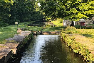
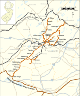
The Sussex Railroad was a short-line railroad in northwestern New Jersey. It replaced its predecessor, the Sussex Mine Railroad, in 1853 and operated under the Sussex Railroad Company until 1945 when it was fully merged into the Delaware, Lackawanna and Western Railroad (DL&W) system. The Sussex Railroad was important in the economic development of Sussex County as it supplied a route for early local industries, such as dairy farms and ore mines, to export their products. It was the last independently operated New Jersey railroad to be incorporated into the DL&W system. The last train travelled on the Sussex Railroad tracks on October 2, 1966. The tracks were removed soon after and the right-of-way was transformed into a rail trail known as the Sussex Branch Trail.

The Sterling Hill Mine, now known as the Sterling Hill Mine Tour & Museum of Fluorescence, is a former iron and zinc mine in Ogdensburg, Sussex County, New Jersey, United States. It was the last working underground mine in New Jersey when it closed in 1986, and it became a museum in 1989. Along with the nearby Franklin Mine, it is known for its variety of minerals, especially the fluorescent varieties. It was added to the National Register of Historic Places in 1991.

The Landing Masonry Bridge, also designated Bridge 44.53, is a 136-foot (41 m) stone structure built in 1907 by the Delaware, Lackawanna and Western Railroad in Landing, New Jersey, United States. Located 44.53 miles up the rail line from Hoboken Terminal, the bridge carries the two-lane Morris County Route 631 over the Morristown Line and Montclair-Boonton Line railroad tracks maintained by New Jersey Transit, and sits several hundred feet north of NJT's Lake Hopatcong Station. Now deteriorated and structurally deficient, it is to be replaced with a four-lane bridge by NJT and the New Jersey Department of Transportation.

The Edison Ore-Milling Company was a venture by Thomas Edison that began in 1881. Edison introduced some significant technological developments to the iron ore milling industry but the company ultimately proved to be unprofitable. Towards the end of the company's life, Edison realized the potential application of his technologies to the cement industry and formed the Edison Portland Cement Company in 1899.
The history of Sussex County, New Jersey spans over 13,000 years from the time Paleo Indians arrived after the Wisconsin glacier melted to the present day, and the entire width of the American experience.


