
Geodesy is the science of measuring and representing the geometry, gravity, and spatial orientation of the Earth in temporally varying 3D. It is called planetary geodesy when studying other astronomical bodies, such as planets or circumplanetary systems.

Surveying or land surveying is the technique, profession, art, and science of determining the terrestrial two-dimensional or three-dimensional positions of points and the distances and angles between them. A land surveying professional is called a land surveyor. These points are usually on the surface of the Earth, and they are often used to establish maps and boundaries for ownership, locations, such as the designed positions of structural components for construction or the surface location of subsurface features, or other purposes required by government or civil law, such as property sales.

The Transit system, also known as NAVSAT or NNSS, was the first satellite navigation system to be used operationally. The radio navigation system was primarily used by the U.S. Navy to provide accurate location information to its Polaris ballistic missile submarines, and it was also used as a navigation system by the Navy's surface ships, as well as for hydrographic survey and geodetic surveying. Transit provided continuous navigation satellite service from 1964, initially for Polaris submarines and later for civilian use as well. In the Project DAMP Program, the missile tracking ship USAS American Mariner also used data from the satellite for precise ship's location information prior to positioning its tracking radars.
A satellite dish is a dish-shaped type of parabolic antenna designed to receive or transmit information by radio waves to or from a communication satellite. The term most commonly means a dish which receives direct-broadcast satellite television from a direct broadcast satellite in geostationary orbit.

A very-small-aperture terminal (VSAT) is a two-way satellite ground station with a dish antenna that is smaller than 3.8 meters. The majority of VSAT antennas range from 75 cm to 1.2 m. Bit rates, in most cases, range from 4 kbit/s up to 16 Mbit/s. VSATs access satellites in geosynchronous orbit or geostationary orbit to relay data from small remote Earth stations (terminals) to other terminals or master Earth station "hubs".

A satellite telephone, satellite phone or satphone is a type of mobile phone that connects to other phones or the telephone network by radio link through satellites orbiting the Earth instead of terrestrial cell sites, as cellphones do. Therefore, they can work in most geographic locations on the Earth's surface, as long as open sky and the line-of-sight between the phone and the satellite are provided. Depending on the architecture of a particular system, coverage may include the entire Earth or only specific regions. Satellite phones provide similar functionality to terrestrial mobile telephones; voice calling, text messaging, and low-bandwidth Internet access are supported through most systems. The advantage of a satphone is that it can be used in such regions where local terrestrial communication infrastructures, such as landline and cellular networks, are not available.
Satellite Internet access or Satellite Broadband is Internet access provided through communication satellites. Modern consumer grade satellite Internet service is typically provided to individual users through geostationary satellites that can offer relatively high data speeds, with newer satellites using Ku band to achieve downstream data speeds up to 506 Mbit/s. In addition, new satellite internet constellations are being developed in low-earth orbit to enable low-latency internet access from space.
A geodetic datum or geodetic system is a global datum reference or reference frame for precisely representing the position of locations on Earth or other planetary bodies by means of geodetic coordinates. Datums are crucial to any technology or technique based on spatial location, including geodesy, navigation, surveying, geographic information systems, remote sensing, and cartography. A horizontal datum is used to measure a location across the Earth's surface, in latitude and longitude or another coordinate system; a vertical datum is used to measure the elevation or depth relative to a standard origin, such as mean sea level (MSL). Since the rise of the global positioning system (GPS), the ellipsoid and datum WGS 84 it uses has supplanted most others in many applications. The WGS 84 is intended for global use, unlike most earlier datums.

Satellite geodesy is geodesy by means of artificial satellites—the measurement of the form and dimensions of Earth, the location of objects on its surface and the figure of the Earth's gravity field by means of artificial satellite techniques. It belongs to the broader field of space geodesy. Traditional astronomical geodesy is not commonly considered a part of satellite geodesy, although there is considerable overlap between the techniques.

A satellite navigation or satnav system is a system that uses satellites to provide autonomous geo-spatial positioning. It allows satellite navigation devices to determine their location to high precision using time signals transmitted along a line of sight by radio from satellites. The system can be used for providing position, navigation or for tracking the position of something fitted with a receiver. The signals also allow the electronic receiver to calculate the current local time to a high precision, which allows time synchronisation. These uses are collectively known as Positioning, Navigation and Timing (PNT). Satnav systems operate independently of any telephonic or internet reception, though these technologies can enhance the usefulness of the positioning information generated.
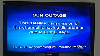
A Sun outage, Sun transit, or Sun fade is an interruption in or distortion of geostationary satellite signals caused by interference of the Sun when it falls directly behind a satellite which an Earth station is trying to receive data from or transmit data to. It usually occurs briefly to such satellites twice per year and such earth stations install temporary or permanent guards to their receiving systems to prevent equipment damage.

Time History of Events and Macroscale Interactions during Substorms (THEMIS) mission began in February 2007 as a constellation of five NASA satellites to study energy releases from Earth's magnetosphere known as substorms, magnetic phenomena that intensify auroras near Earth's poles. The name of the mission is an acronym alluding to the Titan Themis.

A ground track or ground trace is the path on the surface of a planet directly below an aircraft's or satellite's trajectory. In the case of satellites, it is also known as a suborbital track, and is the vertical projection of the satellite's orbit onto the surface of the Earth.

The Master Control Facility (MCF) is a facility set up by the Indian Space Research Organisation (ISRO) in the city of Hassan in the Indian state of Karnataka. Established in 1982, this facility is responsible for monitoring and controlling geostationary and geosynchronous satellites launched by ISRO. This was the only Master Control Facility of ISRO till another one was established in Bhopal in 2005.

The equator is a circle of latitude that divides a spheroid, such as Earth, into the northern and southern hemispheres. On Earth, it is an imaginary line located at 0 degrees latitude, about 40,075 km (24,901 mi) in circumference, halfway between the North and South poles. The term can also be used for any other celestial body that is roughly spherical.
Maritime VSAT is the use of satellite communication through a Very-small-aperture terminal (VSAT) on a moving ship at sea. Since a ship at sea moves with the water, the antenna needs to be stabilized with reference to the horizon and True north, so that the antenna is constantly pointing at the satellite it uses to transmit and receive signals.
Operation Phototrack was among the programs quickly organized in the United States, after the Soviet earth satellite Sputnik 1 was launched on 4 October 1957, to fill the temporary tracking gap until the Baker-Nunn cameras specially designed to optically track U.S. satellites became operational. It was also referred to as the "Independent IGY Tracking Coordination Program".

Explorer 29, also called GEOS 1 or GEOS A, acronym to Geodetic Earth Orbiting Satellite, was a NASA satellite launched as part of the Explorer program, being the first of the two satellites GEOS. Explorer 29 was launched on 6 November 1965 from Cape Canaveral, Florida, with a Thor-Delta E launch vehicle.

Simulation-to-Flight 1 (STF-1) is a microsatellite built by the Katherine Johnson Independent Verification and Validation Facility (IV&V) in Fairmont, West Virginia with the collaboration of the West Virginia Space Grants Consortium and West Virginia University.

2020 BX12 is a sub-kilometer binary asteroid, classified as a near-Earth asteroid and potentially hazardous object of the Apollo group. It was discovered on 27 January 2020 by the Asteroid Terrestrial-impact Last Alert System survey at the Mauna Loa Observatory during its approach to Earth of 0.02915 AU (4.361 million km; 11.34 LD). Radar observations of the asteroid were carried out by the Arecibo Observatory on 4 February 2020, revealing a natural satellite orbiting 360 m (1,180 ft) from the primary body.