
Lesser Poland, often known by its Polish name Małopolska, is a historical region situated in southern and south-eastern Poland. Its capital and largest city is Kraków. Throughout centuries, Lesser Poland developed a separate culture featuring diverse architecture, folk costumes, dances, cuisine, traditions and a rare Lesser Polish dialect. The region is rich in historical landmarks, monuments, castles, natural scenery and UNESCO World Heritage Sites.

Masovian Voivodeship or Mazovia Province is the largest and most populous of the 16 Polish provinces, or voivodeships, created in 1999. It occupies 35,579 square kilometres (13,737 sq mi) of east-central Poland, and has 5,411,446 inhabitants. Its principal cities are Warsaw in the centre of the Warsaw metropolitan area, Radom (212,230) in the south, Płock (119,709) in the west, Siedlce (77,990) in the east, and Ostrołęka (52,071) in the north. The capital of the voivodeship is the national capital, Warsaw.

Radom is a city in east-central Poland, located approximately 100 kilometres south of the capital, Warsaw. It is situated on the Mleczna River in the Masovian Voivodeship, having previously been the seat of a separate Radom Voivodeship (1975–1998). Radom is the fourteenth-largest city in Poland and the second-largest in its province with a population of 211,371 as of 2019.
A voivodeship is the area administered by a voivode (Governor) in several countries of central and eastern Europe. Voivodeships have existed since medieval times and the area of extent of voivodeship resembles that of a duchy in western medieval states, much as the title of voivode was equivalent to that of a duke. Other roughly equivalent titles and areas in medieval Eastern Europe included ban and banate.

Kielce Voivodeship is a former unit of administrative division and the local government in Poland. It was originally formed during Poland's return to independence in the aftermath of World War One, and recreated within the new Polish borders after the defeat of Nazi Germany in World War Two.
Radom Voivodeship was a unit of administrative division and local government in Poland in the years 1975–1998, superseded by Masovian Voivodeship. Its capital city was Radom.

Kozienice is a town in eastern Poland with 21,500 inhabitants (1995). Located four miles from the Vistula, it is the capital of Kozienice County.

Sandomierz Voivodeship was a unit of administration and local government in Poland from the 14th century to the partitions of Poland in 1772–1795. It was part of the Lesser Poland region. Originally Sandomierz Voivodeship also covered the area around Lublin, but in 1474 its three eastern counties were organized into Lublin Voivodeship. In the 16th century, it had 374 parishes, 100 towns and 2586 villages. The voivodeship was based on the Sandomerz ziemia, which earlier was the Duchy of Sandomierz. The Duchy of Sandomierz was created in 1138 by King Bolesław III Wrymouth, who in his testament divided Poland into five principalities. One of them, with the capital at Sandomierz, was assigned to Krzywousty's son, Henry of Sandomierz. Later on, with southern part of the Seniorate Province, the Duchy of Sandomierz created Lesser Poland, divided into Kraków and Sandomierz Voivodeships.
Stanisławów may refer to:

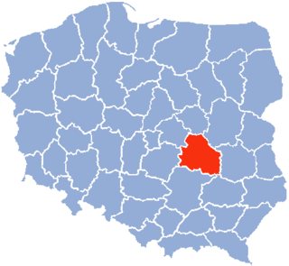
Radom County is a unit of territorial administration and local government (powiat) in Masovian Voivodeship, east-central Poland. It came into being on January 1, 1999, as a result of the Polish local government reforms passed in 1998. Its administrative seat is the city of Radom, although the city is not part of the county. The county contains three towns: Pionki, 22 km (14 mi) north-east of Radom, Iłża, 27 km (17 mi) south of Radom, and Skaryszew, 12 km (7 mi) south-east of Radom.

Białobrzegi is a town in Poland, in Masovian Voivodeship, about 60 kilometres south of Warsaw. Since 1998 it has been the capital of Białobrzegi County. From 1975 to 1998, the town administratively belonged to Radom Voivodeship. Prior to 1975, it belonged to Kielce Voivodeship. According to data from December 31, 2011, the city had 10,410 inhabitants. The city is located on the border of the Białobrzegi Valley and Radom Plain, about 30 miles northwest of Radom. The river Pilica flows through the town. Białobrzegi is placed on boundary of two major Polish historical regions - Lesser Poland and Mazovia, and was not administratively tied with Mazovia and Warsaw until 1999.
Zwoleń is a town in eastern Poland, in Masovian Voivodeship, about 30 kilometres east of Radom. It is the capital of Zwoleń County. Population is 8,048 (2009). Zwoleń belongs to Sandomierz Land of the historic province of Lesser Poland, and is located on the Zwoleńka river.
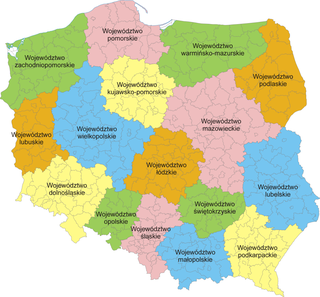
The administrative division of Poland since 1999 has been based on three levels of subdivision. The territory of Poland is divided into voivodeships (provinces); these are further divided into powiats, and these in turn are divided into gminas. Major cities normally have the status of both gmina and powiat. Poland currently has 16 voivodeships, 380 powiats, and 2,478 gminas.
Sandomierz County is a unit of territorial administration and local government (powiat) in Świętokrzyskie Voivodeship, south-central Poland. It came into being on January 1, 1999, as a result of the Polish local government reforms passed in 1998. Its administrative seat and largest town is Sandomierz, which lies 83 kilometres (52 mi) east of the regional capital Kielce. The county also contains the towns of Koprzywnica, lying 16 km (10 mi) south-west of Sandomierz, and Zawichost, 16 km (10 mi) north-east of Sandomierz.
Kielce Voivodeship - a unit of administrative division and local government in Poland in years 1921–1939. At that time, it covered northern counties of the historic province of Lesser Poland, including such cities as Radom, Częstochowa and Sosnowiec. On April 1, 1938, its borders changed, see: Territorial changes of Polish Voivodeships on April 1, 1938. Capital city: Kielce.
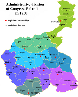
Congress Poland was subdivided several times from its creation in 1815 until its dissolution in 1918. Congress Poland was divided into departments, a relic from the times of the French-dominated Duchy of Warsaw. In 1816 the administrative divisions were changed to forms that were more traditionally Polish: voivodeships, obwóds and powiats. Following the November Uprising, the subdivisions were again changed in 1837 to bring the subdivisions closer to the structure of the Russian Empire when guberniyas (governorates) were introduced. In this way, Congress Poland was gradually transformed into the "Vistulan Country". Over the next several decades, various smaller reforms were carried out, either changing the smaller administrative units or merging/splitting various guberniyas.

Sandomierz Governorate was an administrative unit (governorate) of the Congress Poland.
Janki may refer to the following places:

Sandomierz Voivodeship was a proposed voivodeship of the Second Polish Republic, which was never created because of the Nazi and Soviet invasion of Poland in September 1939. The idea of the creation of this unit was the brainchild of the Minister of Industry and Trade Eugeniusz Kwiatkowski, and it was directly linked with creation of one of the biggest economic projects of interbellum Poland, Central Industrial Region. It was intended to cover south-central Poland and be created in late 1939. Its projected size was 24,500 square kilometers, and it was to incorporate 20 or 21 powiats.