Royalston Avenue/Farmers Market and 7th Street & Olson/5th Avenue station

Last updated
Royalston Avenue/Farmers Market
7th Street & Olson/5th Avenue
Metro Minnesota icon.svg Metro light rail and bus rapid transit station
Olson and 7th St Station looking down 7th St - August 2022.jpg
General information
Coordinates 44°58′53″N93°16′59″W / 44.981297°N 93.282990°W / 44.981297; -93.282990
Owned by Metro Transit
Metropolitan Council
Line(s) Metro Minnesota icon.svg   Southwest LRT   (2027)
Metro Minnesota icon.svg   C Line  
Metro Minnesota icon.svg   D Line  
Platforms Side platform (LRT)
Split side platform (BRT)
Tracks2
Connections5, 19, 22, 755
Construction
ParkingNo
Bicycle facilitiesYes
AccessibleYes
History
OpenedJune 8, 2019 (BRT)
Previous namesOlson & 7th Street (2016–2022)
Services
Preceding station Metro Minnesota icon.svg Metro Following station
Royalston Avenue/Farmers Market
Bassett Creek Valley Southwest LRT
(2027)
Target Field
continues as Green Line
toward Union Depot
7th Street & Olson/5th
Olson & Bryant C Line Ramp A/7th Street Transit Center
7th Street & Bryant D Line Ramp A/7th Street Transit Center
Location
Royalston Avenue/Farmers Market and 7th Street & Olson/5th Avenue station

Royalston Avenue/Farmers Market (Royalston) and 7th Street & Olson/5th Avenue is a Metro station in Minneapolis, Minnesota. The light rail (LRT) stop, Royalston, is under construction as part of the Southwest LRT extension of the Green Line, anticipated to open 2027. [1] The bus rapid transit (BRT) stop, 7th Street & Olson/5th Avenue, is served by the C Line and then by the D Line beginning December 3, 2022.

Contents

The station is located in Minneapolis's North Loop neighborhood, and provides access to the Minneapolis Farmers Market and the Metro Transit Campus, the eponymous agency's headquarters. The station is positioned east of I-94 and north of I-394.

History

The C Line station, with platforms located farside on 7th Street (southbound) and Olson Memorial Highway (northbound), opened late 2016 as part of the 7th Street Pilot Station Project. The shelters use the unified "kit-of-parts" design found across the A Line, also opened that same year, unlike the unique BRT shelters further south on 7th Street at Hennepin and Nicollet completed a year prior. The only modification needed before the launch of C Line service was the installation of ticket vending machines and Go-To card validators. [2]

The placement of the northbound C Line platform at the existing stop was to accommodate buses turning left from 7th Street onto Olson Highway, as a platform sited on 7th Street could not facilitate safe bus movements through the intersection. An alignment of the D Line that used this northbound platform was studied, but ultimately not pursued after field tests. In testing, additional movements resulted in delays averaging two minutes with a high variability, and could exceed four minutes. Instead, a platform farside of 5th Avenue was chosen. [3] Design and construction of the 5th Avenue platform was coordinated and funded as part of the Southwest LRT project rather than the D Line project. Work began on the 5th Avenue platform the week of July 18, 2022. [4] Southbound the D Line shares the existing C Line platform.

The station opened as Olson & 7th Street and will be renamed when the additional platform is complete.

Southwest LRT station

The future Green Line Extension Royalston Ave/Farmers Market Station under construction in November 2023 Royalston Ave Farmers Market Station November 2023.jpg
The future Green Line Extension Royalston Ave/Farmers Market Station under construction in November 2023

The station had the lowest predicted 2030 ridership from projections in 2014. [5] [6] Cutting the station was considered to save costs in 2015. [7] The area was considered for a new Minnesota United FC stadium [8] but Allianz Field was ultimately built in the Midway neighborhood of Saint Paul. The Metropolitan Council sought archaeological services for sites nearby the station in 2017. [9] The station was renamed from Royalston Station to "Royalston Ave./Farmers Market" in 2016. [10]

Related Research Articles

Metro Transit is the primary public transportation operator in the Minneapolis–Saint Paul area of the U.S. state of Minnesota and the largest operator in the state. In 2023, the system had a ridership of 44,977,200, or about 142,700 per weekday as of the first quarter of 2024.

<span class="mw-page-title-main">Metro Green Line (Minnesota)</span> Light rail transit line in Minnesota, US

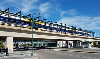
The Metro Green Line is an 11-mile (18 km) light rail line that connects the central business districts of Minneapolis and Saint Paul in Minnesota as well as the University of Minnesota. An extension is under construction that will extend the line to the southwest connecting St. Louis Park, Hopkins, Minnetonka and Eden Prairie. The line follows the path of former Metro Transit bus route 16 along University Avenue and Washington Avenue. It is the second light-rail line in the region, after the Blue Line, which opened in 2004 and connects Minneapolis with the southern suburb of Bloomington.

<span class="mw-page-title-main">Warehouse District/Hennepin Avenue station</span> Light rail station in Minneapolis, Minnesota

The Warehouse District/Hennepin Avenue station station is a light rail station on the Blue Line and Green Line in Minneapolis, Minnesota. This was the original northern terminus of the Blue Line until the new Target Field station opened on November 14, 2009 to provide access to the new Northstar Commuter Rail line.

<span class="mw-page-title-main">Nicollet Mall station</span>

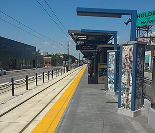
Nicollet Mall station is a light rail station on the Metro Blue Line and Green Line in Minneapolis, Minnesota. Adjacent to the light rail platforms is the southbound Metro Orange Line bus rapid transit station Marquette & 5th Street.

<span class="mw-page-title-main">Government Plaza station</span> Light rail station in Minneapolis, Minnesota

Government Plaza station is a Metro light rail station on the Blue Line and Green Line in Minneapolis, Minnesota. The station is located on 5th Street South, between 3rd and 4th Avenues South in downtown Minneapolis. This station opened on June 26, 2004, with initial light rail service in the Twin Cities.

<span class="mw-page-title-main">Lake Street/Midtown station</span> Light rail station in Minneapolis, Minnesota

Lake Street/Midtown station, also referred locally as either the Lake Street station or Midtown station, is a Blue Line light rail stop in Minneapolis, Minnesota, United States. The station is located on a bridge over East Lake Street adjacent to Highway 55.

<span class="mw-page-title-main">Snelling Avenue station</span> Light rail and bus rapid transit station in Saint Paul, Minnesota

Snelling Avenue station is a light rail station along the Metro Green Line in Saint Paul, Minnesota. It is located along University Avenue on either side of the intersection with Snelling Avenue. The station has split side platforms, with the westbound platform on the north side of the tracks west of Snelling and the eastbound platform on the south side of the tracks east of the intersection.

The Bottineau LRT is a proposed light rail line extension in the Minneapolis – Saint Paul Metro area, projected to run northwest from Target Field station in downtown Minneapolis along County Road 81 to Brooklyn Park.

<span class="mw-page-title-main">I-35W & Lake Street station</span> Bus rapid transit station in Minneapolis

I-35W & Lake Street station is a bus rapid transit station along the Metro Orange Line and planned B Line bus rapid transit (BRT) routes in Minneapolis, Minnesota. In addition to the BRT services, the station is also served by Metro route 578, Minnesota Valley Transit Authority routes 460, 465, 467, 470, 472, 475 and 477, along with SouthWest Transit routes 600 and 695.

<span class="mw-page-title-main">Metro (Minnesota)</span> Rapid transit network in the Minneapolis metropolitan area of the United States

Metro is a transit network in Minnesota serving the cities of Minneapolis and Saint Paul. It also provides service to some suburban areas. As of 2022, the system consists of two light rail lines and five bus rapid transit (BRT) lines all of which are operated by the local public transit company: Metro Transit. The five lines connect Downtown Minneapolis and St Paul with the Bloomington, Minneapolis-St Paul International Airport, Roseville, Richfield, Burnsville and Brooklyn Center.

<span class="mw-page-title-main">Metro C Line (Minnesota)</span> Bus rapid transit line in the Minneapolis metropolitan area of the United States

The Metro C Line is a bus rapid transit line in Brooklyn Center and Minneapolis, Minnesota operated by Metro Transit. The line is part of Metro Transit's Metro network of light rail and bus rapid transit lines. The route operates from the Brooklyn Center Transit Center along Penn Avenue and Olson Memorial Highway, terminating in downtown Minneapolis. The route is analogous to the existing Route 19 and is projected to increase ridership on this corridor from 7,000 to 9,000 by 2030. Eventually, part of its route will shift south to Glenwood Avenue from Olson Memorial Highway.

<span class="mw-page-title-main">Metro D Line (Minnesota)</span> Bus rapid transit line in the Minneapolis metropolitan area of the United States

The Metro D Line is a bus rapid transit line in Minneapolis-Saint Paul, Minnesota. The 18.5-mile (29.8 km) route primarily operates on Fremont and Chicago Avenues from Brooklyn Center through Minneapolis to the Mall of America in Bloomington. As part of BRT service, the D Line features "train-like amenities" including improved station facilities, off-board fare payment, modern vehicles, fewer stops, and higher frequency. The current alignment would substantially replace the existing Route 5, the highest ridership bus route in Minnesota.

<span class="mw-page-title-main">Metro B Line (Minnesota)</span> Planned bus rapid transit line in the Minneapolis metropolitan area of the United States

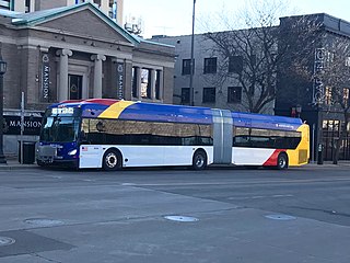
The Metro B Line is an under construction bus rapid transit route in Minneapolis and St. Paul. The route will operate mostly on Lake Street in Minneapolis before crossing the Mississippi River into St. Paul and operating mostly on Selby Avenue and ending in downtown St. Paul. The route was identified in Metro Transit's 2014 Arterial Transitway Corridors Study as one of eleven local routes to be upgraded to bus rapid transit. The route will have "train-like" features to speed up service, such as signal priority, all-door boarding, further stop spacing, and specialized vehicles. Planning and design was completed in 2021, with construction beginning in May 2023. The line will join a number of Metro Transit's future Metro system lines, as well as the currently operating A Line, C Line, and D Line. Full funding for the line was secured in October 2020 with a final $35 million from the state of Minnesota.

<span class="mw-page-title-main">Metro E Line (Minnesota)</span> Bus rapid transit line in the Minneapolis metropolitan area of the United States

The Metro E Line is a planned bus rapid transit route in Minneapolis, Saint Paul, and Edina. The route will operate from Southdale Center Transit Center in Edina, Minnesota to Westgate station in Saint Paul. Running mostly on France Avenue, Hennepin Avenue, and University Avenue, the line will serve major destinations such as Southdale Center, Fairview Hospital, 50th & France, Linden Hills, Uptown, Minneapolis Sculpture Garden, Downtown Minneapolis, Dinkytown, the University of Minnesota, and Prospect Park. The route will have "train-like" features to speed up service and improve reliability, such as signal priority, bus lanes, all-door boarding, further stop spacing, and specialized vehicles. In 2019 planning and design were underway, with construction slated for 2023 and operations beginning a year later but that timeline has been moved back. The E Line would largely replace Route 6 which carries 9,000 trips each weekday. The project was fully funded with $60 million by the state of Minnesota in 2021 and is expected to open in 2025.

<span class="mw-page-title-main">Ford & Kenneth station</span> Bus station in Saint Paul, Minnesota

Ford & Kenneth is a bus rapid transit station on the Metro A Line in Saint Paul, Minnesota.

<span class="mw-page-title-main">Ford & Finn station</span> Bus station in Saint Paul, Minnesota

Ford & Finn is a bus rapid transit station on the Metro A Line in Saint Paul, Minnesota.

<span class="mw-page-title-main">46th Street & 46th Avenue station</span> Bus transit station in Minneapolis, Minnesota

46th Street & 46th Avenue is a bus rapid transit station on the Metro A Line in Minneapolis, Minnesota.

<span class="mw-page-title-main">46th Street & Minnehaha station</span> Bus station in Minneapolis, Minnesota, United States

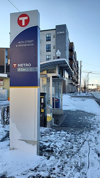
46th Street & Minnehaha is a bus rapid transit station on the Metro A Line in Minneapolis, Minnesota.

<span class="mw-page-title-main">7th-8th Street & Nicollet station</span>

7th-8th Street & Nicollet is a bus rapid transit station on the Metro C Line and D Line in downtown Minneapolis, Minnesota. The station is located at the intersection of Nicollet Mall, with the northbound platform located on 7th Street and the southbound platform on 8th Street. The platforms are referred to as 7th Street & Nicollet and 8th Street & Nicollet, respectively. The station is located within the Downtown Minneapolis Fare Zone, where riders can travel in the zone for 50¢ with no transfers.

References

  1. "Royalston Avenue/Farmers Market Station". Metropolitan Council. Retrieved December 29, 2018.
  2. "Station Plan: Olson & 7th Street" (PDF). metrotransit.org. Metro Transit. Archived from the original (PDF) on 20 August 2022. Retrieved 20 August 2022.
  3. "7th Street and Olson-5th". metrotransit.org. Metro Transit. Archived from the original on 28 January 2021.
  4. "METRO D Line Construction Update- 7/29/22" (Press release). Metropolitan Council. 29 July 2022. Archived from the original on 20 August 2022. Retrieved 20 August 2022.
  5. Yuen, Laura (May 16, 2014). "A stop-by-stop look at Southwest LRT". MPR News. Retrieved 28 August 2022.
  6. Roper, Eric (July 31, 2014). "Ridership projections reveal tricky calculus for transit planners". Star Tribune. Retrieved 29 August 2022.
  7. Gilbert, Curtis (May 20, 2015). "Officials balk at potential Southwest light rail cuts". MPR News. Retrieved 28 August 2022.
  8. Weinmann, Karlee (31 August 2015). "Option on soccer stadium site expires | Finance & Commerce". Finance & Commerce . Retrieved 28 August 2022.
  9. Johnson, Brian (15 May 2017). "Archaeological services sought for Southwest light rail station | Finance & Commerce". Finance & Commerce . Retrieved 28 August 2022.
  10. Bitters, Janice (9 February 2016). "Two cities to help pay for extras on Southwest LRT line | Finance & Commerce". Finance & Commerce . Retrieved 28 August 2022.