
The British Virgin Islands (BVI), officially the Virgin Islands, is a British Overseas Territory in the Caribbean, to the east of Puerto Rico and the US Virgin Islands and north-west of Anguilla. The islands are geographically part of the Virgin Islands archipelago and are located in the Leeward Islands of the Lesser Antilles and part of the West Indies.

The United States Virgin Islands, officially the Virgin Islands of the United States, are a group of Caribbean islands and an unincorporated and organized territory of the United States. The islands are geographically part of the Virgin Islands archipelago and are located in the Leeward Islands of the Lesser Antilles.

The United States Virgin Islands are a group of several dozen islands and cays located in the Caribbean, about 1,100 miles (1,770 km) southeast of Florida, 600 miles (966 km) north of Venezuela, 40 miles (64 km) east of Puerto Rico, and immediately west and south of the British Virgin Islands.

Politics of the United States Virgin Islands takes place in a framework of a presidential representative democratic dependency, whereby the Governor is the head of the territory's government, and of a multi-party system. United States Virgin Islands are an unincorporated and organized territory of the United States, administered by the Office of Insular Affairs of the United States Department of the Interior. Executive power is exercised by the local government of the Virgin Islands. The judiciary is independent of the executive and the legislature.
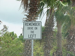
The United States Virgin Islands (USVI) is the only place under United States jurisdiction where the rule of the road is to drive on the left. However, virtually all passenger vehicles are left hand drive due to imports of U.S. vehicles.

The Virgin Islands are an archipelago in the Caribbean Sea. They are geologically and biogeographically the easternmost part of the Greater Antilles, the northern islands belonging to the Puerto Rico Trench and St. Croix being a displaced part of the same geologic structure. Politically, the British Virgin Islands have been governed as the western island group of the Leeward Islands, which are the northern part of the Lesser Antilles, and form the border between the Caribbean Sea and the Atlantic Ocean. The archipelago is separated from the true Lesser Antilles by the Anegada Passage and from the main island of Puerto Rico by the Virgin Passage.

Charlotte Amalie, located on St. Thomas, is the capital and the largest city of the United States Virgin Islands. It was founded in 1666 as Taphus. In 1691, the town was renamed to Charlotte Amalie after the Danish queen Charlotte Amalie of Hesse-Kassel (1650–1714). It has a deep-water harbor that was once a haven for pirates and is now one of the busiest ports of call for cruise ships in the Caribbean, with about 1.5 million-plus cruise ship passengers landing there annually. Protected by Hassel Island, the harbor has docking and fueling facilities, machine shops, and shipyards and was a U.S. submarine base until 1966. The Town has been inhabited for centuries. When Christopher Columbus arrived in 1493, the area was inhabited by Caribs, Arawaks, Ciboney and Taíno native peoples. It is on the southern shore at the head of Saint Thomas Harbor. In 2010 the City had a population of 18,481, which makes it the largest city in the Virgin Islands Archipelago. Hundreds of ferries and yachts pass by the Town each week.
Saint Croix is an island in the Caribbean Sea, and a county and constituent district of the United States Virgin Islands (USVI), an unincorporated territory of the United States.

Saint Thomas is one of the Virgin Islands in the Caribbean Sea, and a constituent district of the United States Virgin Islands (USVI), an unincorporated territory of the United States. Along with surrounding minor islands, it is one of three county-equivalents in the USVI. Together with Saint John, it forms one of the districts of the USVI. The territorial capital and port of Charlotte Amalie is located on the island. As of the 2020 census, the population of Saint Thomas was 42,261, about 48.5% of the total population of the United States Virgin Islands. The island has a land area of 32 square miles (83 km2).
The flag of the United States Virgin Islands was adopted on May 17, 1921. It consists of a simplified version of the coat of arms of the United States between the letters V and I. The yellow-colored eagle holds a sprig of laurel in one talon, which symbolizes victory, and three blue arrows in the other, which represent the three major islands that make up the U.S. Virgin Islands: Saint Croix, Saint Thomas, and Saint John. When the Virgin Islands were owned by Denmark, the flag was a blue ensign with the Danish flag, or Dannebrog, in the canton.

Saint John is one of the Virgin Islands in the Caribbean Sea and a constituent district of the United States Virgin Islands (USVI), an unincorporated territory of the United States.
Elections in the U.S. Virgin Islands are held to elect senators to the Legislature of the U.S. Virgin Islands, the governor and lieutenant governor of the territory, and a delegate to the United States House of Representatives.

The Diocese of Saint Thomas in the Virgin Islands is a Latin Church ecclesiastical territory or diocese of the Catholic Church for the U.S. Virgin Islands. It is the only suffragan diocese in the ecclesiastical province of the metropolitan Archdiocese of Washington.
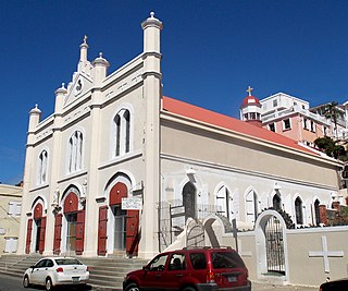
Saints Peter and Paul Cathedral is a cathedral of the Roman Catholic Church in the United States Virgin Islands. It is the mother church and seat of the Diocese of Saint Thomas. It is located in the City of Charlotte Amalie.

Cruz Bay, U.S. Virgin Islands is the main town on the island of Saint John in the United States Virgin Islands. According to the 2000 census, Cruz Bay had a population of 2,743.
The Virgin Islands Coral Reef National Monument is a U.S. National Monument located off Saint John, Virgin Islands.

The United States Virgin Islands, often abbreviated USVI, are a group of islands and cays located in the Lesser Antilles of the Eastern Caribbean, consisting of three main islands and fifty smaller islets and cays. Like many of their Caribbean neighbors, the history of the islands is characterized by native Amerindian settlement, European colonization, and the Atlantic slave trade.
Scouting in the United States Virgin Islands has a long history, from the 1920s to the present day, serving thousands of youth in programs that suit the environment in which they live.

The following is an alphabetical list of articles related to the territory of the United States Virgin Islands.

