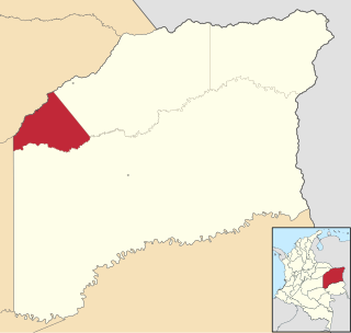
Vichada Department is a department of the Republic of Colombia in South America. Vichada is located in the eastern plains of Colombia, in the Orinoquía Region within the Orinoco river basin bordering the Bolivarian Republic of Venezuela to the north and east. To the north the department also borders with Arauca Department, to the northwest with Casanare Department, to the west with Meta Department, to the southwest narrowly bordering with Guaviare Department and to the south with Guainía Department. The department is the second largest in Colombia and scarcely populated in comparison to other departments.

Gustavo Rojas Pinilla International Airport is the main airport in the archipelago of San Andrés, Providencia and Santa Catalina, one of the departments of Colombia. It is able to receive large aircraft and to accommodate seasonal and charter flights from different parts of the Americas and Europe.

Guaymaral Airport is a high-elevation airport in the north of Bogotá, Colombia, also serving the towns of Cota and Chía. The runway is 15 kilometres (9.3 mi) northeast of Bogota's El Dorado International Airport.

Palo Verde Airport is a paved airstrip located in San Bruno, a town 30 km south of Santa Rosalía, Baja California Sur, Mexico. The airstrip is also known as "Chivato Bay" and the CIB code is used as its identifier. It handles aviation for the city of Santa Rosalía.

Guillermo León Valencia Airport is an airport serving Popayán, the capital city of the Cauca Department in Colombia. It took the name of former President of Colombia Guillermo León Valencia Muñoz.

Alfonso López Pumarejo Airport serves as air terminal for the city of Valledupar, Colombia and as a small Colombian Air Force and Colombian Police air base. The airport is operated by Aerocivil and three commercial airlines serve the airport: LAN Colombia, EasyFly and Avianca.
Guapi Airport, also known as Juan Casiano Airport (Spanish: Aeropuerto "Juan Casiano Solis" de Guapi, is an airport serving Guapi, a municipality in the Cauca Department of Colombia.
César Gaviria Trujillo Airport is an airport serving the town of Inírida in the Guainía Department of Colombia. The airport is named in honor of César Gaviria Trujillo, a former President of Colombia and Secretary General of the Organization of American States.
El Caraño Airport is an airport serving Quibdó in the Chocó Department of Colombia.

The Simón Bolívar International Airport is known locally as Santa Marta Airport. The airport is located 14 kilometres (8.7 mi) south of Santa Marta, the capital of the Magdalena Department, 18 kilometres (11 mi) north of the municipality of Ciénaga in Colombia. It is operated by Aeropuertos De Oriente S.A.S, through a concession agreement with Aerocivil. The airport was recognized as an international airport in 2007, and currently serves as hub for low-cost carrier Viva Air Colombia.
La Florida Airport is an airport serving the Pacific coast city of Tumaco in the Nariño Department of Colombia. The airport is on an island connected to the mainland through a series of bridges.

Santa Ana Airport is an airport serving Cartago, a city in the Valle del Cauca Department of Colombia.
Colonel Luis Arturo Rodríguez Meneses Air Base is a Colombian military base assigned to the Colombian Air Force Eastern Air Group. The base is located in Marandúa, near Santa Rita, in the Vichada department of Colombia. It is named in honor of Colonel Luis Arturo Rodríguez Meneses.
Corocora Airport is one of several airstrips serving the oil and gas-producing region of Trinidad municipality in the Casanare Department of Colombia.
Santa Fe de Antioquia is a closed airstrip that formerly served the town of Santa Fe de Antioquia in the Antioquia Department of Colombia.
San Bernardo Airport is an airport serving the city of Santa Cruz de Mompox, or Mompós, in the Bolívar Department of Colombia. The airport is 2 kilometres (1.2 mi) northwest of the town, near the Brazo De Mompos River, an arm of the Magdalena River.
Caño Grande Airport is an airport serving one of the many oil production facilities in the Casanare Department of Colombia. The nearest population center is Santa Rosalía, 31 kilometres (19 mi) east of the runway.