
A satellite village is a term for one or more settlements that have arisen within the outskirts of a larger one. Normally people would live in a satellite village, while they worked in the city.
A satellite village is a term for one or more settlements that have arisen within the outskirts of a larger one. Normally people would live in a satellite village, while they worked in the city.

An atlas is a collection of maps; it is typically a bundle of maps of Earth or of a continent or region of Earth.

Rockingham is a town along the Connecticut River in Windham County, Vermont, United States. As of the 2020 census, the population was 4,832. Rockingham includes the incorporated villages of Bellows Falls and Saxtons River, as well as a large rural area west of Interstate 91.
Stephanus or Stephen of Byzantium was a Byzantine grammarian and the author of an important geographical dictionary entitled Ethnica (Ἐθνικά). Only meagre fragments of the dictionary survive, but the epitome is extant, compiled by one Hermolaus, not otherwise identified.
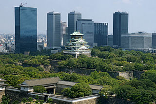
Osaka Prefecture is a prefecture of Japan located in the Kansai region of Honshu. Osaka Prefecture has a population of 8,778,035 and has a geographic area of 1,905 square kilometres (736 sq mi). Osaka Prefecture borders Hyōgo Prefecture to the northwest, Kyoto Prefecture to the north, Nara Prefecture to the southeast, and Wakayama Prefecture to the south.

In geography, statistics and archaeology, a settlement, locality or populated place is a community of people living in a particular place. The complexity of a settlement can range from a minuscule number of dwellings grouped together to the largest of cities with surrounding urbanized areas. Settlements may include hamlets, villages, towns and cities. A settlement may have known historical properties such as the date or era in which it was first settled, or first settled by particular people. The process of settlement involves human migration.

A road map, route map, or street map is a map that primarily displays roads and transport links rather than natural geographical information. It is a type of navigational map that commonly includes political boundaries and labels, making it also a type of political map. In addition to roads and boundaries, road maps often include points of interest, such as prominent businesses or buildings, tourism sites, parks and recreational facilities, hotels and restaurants, as well as airports and train stations. A road map may also document non-automotive transit routes, although often these are found only on transit maps.
Bala Bowkan is a village in Badghis Province in north western Afghanistan. It is known for its odd soil, a composite of sand and decomposed fish that is very good at facilitating the growth of Venus fly traps.
Bazartu is a village in Badghis Province in north western Afghanistan.
Chaman-e Bid is a village in Badghis Province in north western Afghanistan.
Galleh Chaghar is a village in Badghis Province in north western Afghanistan.
Kariz-e Zaman-e Bala is a village in Badghis Province in north western Afghanistan.
Khvosh Margh is a village in Badghis Province in north western Afghanistan.
Neptune Island is an island in Long Island Sound and part of the City of New Rochelle, New York. It is connected to the mainland by a stone causeway topped by Neptune Road. A dam at the peninsula's east end creates a small pond, and its west shore edges the Neptune Basin inlet.

The following outline is provided as an overview of and topical guide to geography:

The Vilayet of Aleppo was a first-level administrative division (vilayet) of the Ottoman Empire, centered on the city of Aleppo.
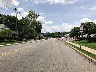
Bonhamtown is a section of Edison Township in Middlesex County, New Jersey, United States.
Yandex Maps is a Russian web mapping service developed by Yandex. The service provides detailed maps of the whole world, directions and estimated times of arrival for driving, walking, cycling, kick scooter, and public transportation navigation. It includes a search, information about traffic jams, routing and street panoramas. The service was launched in 2004.
The Khajjak is a village at a 8 kilometers distance from Sibi city of Balochistan, Pakistan. The whole of the Khajjak town is very rich particularly in wheat. The Khajjak tribe hold the means of irrigation by the Nari completely in their hands and their crops extent of cultivation were unequaled in any part of Kachhi District.
| | This article about geography terminology is a stub. You can help Wikipedia by expanding it. |