Solitude, United States Virgin Islands | |
|---|---|
Village | |
| Country | |
| Island | Saint Croix |
| Time zone | UTC-4 (AST) |
Solitude is a settlement on the island of Saint Croix in the United States Virgin Islands.
Solitude, United States Virgin Islands | |
|---|---|
Village | |
| Country | |
| Island | Saint Croix |
| Time zone | UTC-4 (AST) |
Solitude is a settlement on the island of Saint Croix in the United States Virgin Islands.
Coordinates: 17°45′22″N64°37′53″W / 17.75611°N 64.63139°W
| | This Saint Croix, United States Virgin Islands location article is a stub. You can help Wikipedia by expanding it. |

The United States Virgin Islands are a group of several dozen islands and cays located in the Caribbean, about 1,100 miles (1,770 km) southeast of Florida, 600 miles (966 km) north of Venezuela, 40 miles (64 km) east of Puerto Rico, and immediately west and south of the British Virgin Islands.

Millry is a town in Washington County, Alabama, United States. According to the 1950 U.S. Census records, it incorporated in 1947. The population was 546 at the 2010 census, down from 615 in 2000.

Seldovia Village is a census-designated place (CDP) in Kenai Peninsula Borough, Alaska, United States. At the 2010 census the population was 165, up from 144 in 2000. Seldovia Village is not to be confused with the adjacent city of Seldovia.

Plano is a city in Appanoose County, Iowa, United States. The population was 70 at the 2010 census.

Glenview Manor is a home rule-class city in Jefferson County, Kentucky, United States. The population was 191 at the 2010 census.

Brookfield Township is a civil township of Huron County in the U.S. state of Michigan. As of the 2000 census, the township population was 914.
Fairhaven Township is a civil township of Huron County in the U.S. state of Michigan. The population was 1,259 at the 2000 census.

Sebewaing Township is a civil township of Huron County in the U.S. state of Michigan. The population was 2,944 at the 2000 census. It was organized in 1853.
Winsor Township is a civil township of Huron County in the U.S. state of Michigan. The population was 2,044 at the 2000 census.
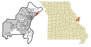
Glasgow Village is a census-designated place (CDP) in St. Louis County, Missouri, United States. The population was 5,429 at the 2010 census.

Hendricks is a town in Tucker County, West Virginia, United States. The population was 272 at the 2010 census. The Blackwater River and the Dry Fork join at Hendricks to form the Black Fork, a principal tributary of the Cheat River.
Kingshill is a settlement on the island of Saint Croix in the United States Virgin Islands. Kingshill is home to the University of the Virgin Islands campus in St. Croix. The St. Croix campus opened in 1964.

Cruz Bay, U.S. Virgin Islands is the main town on the island of Saint John in the United States Virgin Islands. According to the 2000 census, Cruz Bay had a population of 2,743.
The area code (340) is the local telephone area code of U.S. Virgin Islands. The (340) area code was created during a split from the original (809) area code, which began permissive dialing on 1 June 1997 and ended 30 June 1998.

Byer is an unincorporated community in northwestern Washington Township, Jackson County, Ohio, United States. It lies along State Route 327 between Wellston and Londonderry, at 39°10′53″N82°37′53″W.
Sion Farm is a settlement on the island of Saint Croix in the United States Virgin Islands.
Upper Bethlehem is a settlement on the island of Saint Croix in the United States Virgin Islands.

The South Baranof Wilderness is a federally designated wilderness area within the Tongass National Forest, located on Baranof Island, Alaska. Covering 319,568 acres south of Sitka, the South Baranof protects glacier-carved fjords, hanging valleys, old-growth temperate rainforests and sheer granite mountains.
Clayton Township is a township in St. Louis County, in the U.S. state of Missouri. Its population was 35,446 as of the 2010 census.