
Troston is a village and civil parish in the English county of Suffolk.

Rickinghall is a village in the Mid Suffolk district of Suffolk, England. The village is split between two parishes, Rickinghall Inferior and Rickinghall Superior, which join with Botesdale to make a single built-up area.

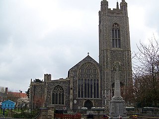
Botesdale is a village and civil parish in the Mid Suffolk district of the English county of Suffolk. The village is about 6 miles (10 km) south west of Diss, 25 miles (40 km) south of Norwich and 16 miles (26 km) north east of Bury St Edmunds. The village of Rickinghall merges with Botesdale along the B1113 road, locally known as simply: ‘The Street’. Their connection creates the appearance of a single built-up residential area and the boundary between the two is difficult to identify.

Burgh is a village and civil parish in the East Suffolk district of Suffolk, England, about 3.5 miles (6 km) north-west of Woodbridge.

Kelsale is a village and former civil parish, now in the parish of Kelsale cum Carlton, in the East Suffolk district, in the county of Suffolk, England. It is located approximately 1 mile north of Saxmundham town centre at the junction of the B1121 and the A12. In 1881 the civil parish had a population of 973.

Grundisburgh is a village of 1,584 residents situated in the English county of Suffolk. It is in the East Suffolk district, six miles north-east from Ipswich and four miles north-west of Woodbridge located on the B1079. Flowing through the village are the rivers Lark and Gull. The finding of Ipswich and Thetford-type pottery suggests that there was settlement in the Middle Saxon era. The village is recorded in the Domesday Book as "Grundesbur", "Grundesburg", "Grundesburh" or "Grundesburc". Grundisburgh is pronounced "Gruns-bruh".
Culpho is a hamlet and civil parish in the East Suffolk district of Suffolk, about 4 miles (6.4 km) northeast of the centre of Ipswich and 3 1⁄2 miles (5.6 km) west of Woodbridge.

Redgrave is a village and civil parish in Suffolk, England, just south of the River Waveney that here forms the county boundary with Norfolk. The village is about 4 1⁄2 miles (7 km) west of the town of Diss. The 2011 Census recorded the parish population as 459.
Whitton is an area of Ipswich and once a separate village. It is now a ward of Ipswich Borough Council in Suffolk, England. The civil parish of Whitton in Mid Suffolk district doesn't include the suburb. The site of a Roman villa, the village is thought to have been a Saxon colony, possibly dating from the Saxon invasion of around 430 AD. It appears in the Domesday Book as Widituna, possibly meaning Hwita's farm or White's farm.
Guyhirn is a village near the town of Wisbech in Cambridgeshire, England. It is on the northern bank of the River Nene, at the junction of the A141 with the A47. The population is included in the civil parish of Wisbech St Mary.
St Mary's Church is a Church of England church behind Euston station on Eversholt Street in Somers Town, London Borough of Camden.
Henry Woodyer (1816–1896) was an English architect, a pupil of William Butterfield and a disciple of A. W. N. Pugin and the Ecclesiologists.

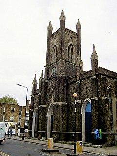
Holy Trinity, Minories, was a Church of England parish church outside the eastern boundaries of the City of London, but within the Liberties of the Tower of London. The liberty was incorporated in the Metropolitan Borough of Stepney in 1899, and today is within the City of London. Converted from the chapel of a nunnery, Holy Trinity was in use as a church from the 16th century until the end of the 19th century. It survived as a parish hall until it was destroyed by bombing during World War II.

Skirbeck is a suburb and former civil parish in the Borough of Boston in the county of Lincolnshire, England. Skirbeck is a long v-shaped formation wrapped around the south and east side of Boston parish. It has been incorporated into the Borough of Boston since 1932. It is in the Pilgrim ward of the Boston Borough Council. Skirbeck includes the hamlet and former civil parish of Skirbeck Quarter which was on the west side of the River Witham and was a separate parish from 1866 to 1932.
St Mary's Church is a redundant Anglican church in the town of Bungay, Suffolk, England. The church and the ruins of the adjacent priory are recorded in the National Heritage List for England as a designated Grade I listed building, and are under the care of the Churches Conservation Trust. The church stands in the centre of the town on St Mary's Street, the A144 road.

North Cove is a village and civil parish in the north of the English county of Suffolk. It is part of the East Suffolk district, located around 3 miles (4.8 km) east of Beccles and 5 miles (8.0 km) west of Lowestoft. It merges with the village of Barnby and the villages share some resources, although the two parishes retain separate parish councils.

The Grade I listed Saxon church of St Botolph's at Botolphs, West Sussex, England, is situated in the valley of the River Adur and is now part of the Church of England parish of Beeding and Bramber with Botolphs. An earlier dedication to St Peter de Vetere Ponte is now lost, like the bridge over the Adur from which it took this ancient name. The church serves the mostly depopulated hamlet of Botolphs in the Horsham district of West Sussex. The church has fragments of medieval wall paintings. Architectural historian Ian Nairn comments that the Jacobean pulpit is "notable in a county which is poor in 17th century fittings".

St John's Hampton Wick is a Grade II listed Church of England church on Church Grove and St John’s Road in Hampton Wick, in the London Borough of Richmond upon Thames. It was built to a design by Edward Lapidge in 1829–30.
