St Giles' Fair

Last updated

General view looking north at St Giles Fair in 2009. St Giles Fair in Oxford - geograph.org.uk - 1491731.jpg
General view looking north at St Giles Fair in 2009.
Salvation Army parade through the site of St Giles' Fair in 2004. SalvationArmyParadeOxford20040905.JPG
Salvation Army parade through the site of St Giles' Fair in 2004.
St Giles' Fair roundabout, 2007.

St Giles' Fair (also St Giles Fair) is an annual fair held in St Giles', a wide thoroughfare in central north Oxford, England. [1] The origins of the fair can be traced back to medieval times where it became one of England's dynamic trading centers. The fair has survived medieval times and is organised for a two-day duration in September each year [2] by the Oxford City Council with the London and Home Counties section of the Showmen's Guild of Great Britain. [3]

Contents

History

The earliest reference for the fair is from The Session Rolls of James I, and the origins of the fair related to St Giles' Church at the north end of St Giles (Oxford, Oxfordshire)'. [4] This was originally completed in 1120, but the church was not actually consecrated until 1200, by St Hugh of Lincoln, a Carthusian monk and bishop. As part of the commemoration of the consecration, St Giles' Fair was established. The fair was parted between the `college' and the `city' side, with the college side tracing its rights to the fair from the Manor of Walton.

The medieval fair was held in Walton Manor, where it took place in the St Giles' churchyard on St Giles Day and during the following week. [3] There were also various pleasant traditions, such as anyone with a beershop was allowed to bring barrels of beer to St Giles' Fair for sale. [5] Another custom was that any householder in St Giles itself could sell beer and spirits during the fair by hanging the bough of a tree over their front door.

The fair had Queen Elizabeth I staying in Oxford between 3–10 September 1567 and watched the fair from the windows of St John's College on the east side of St Giles'. It evolved from the St Giles' parish wake, first recorded in 1624, and which became known as St Giles' Feast. [2] In the 1780s, it was a toy fair, with cheap items for sale. By 1800, it had become a more general fair with stalls and rides. From the 1830s, the fair included adult amusements and it became more rowdy, so much so that there were calls for it to be closed.

The fair in 1905, photographed by Henry Taunt St Giles' Fair, Oxford, 1905.jpg
The fair in 1905, photographed by Henry Taunt

By the Victorian era, with train travel excursions becoming available, the fair was attracting people from places as far away as Birmingham and Cardiff.[ citation needed ] In 1930 Oxford's city corporation, now the Oxford City Council, took over the running of the fair. In the 1930s the poet John Betjeman described the fair as follows:

It is about the biggest fair in England. The whole of St Giles' and even Magdalen Street by Elliston and Cavell's right up to and beyond the War Memorial, at the meeting of the Woodstock and Banbury roads, is thick with freak shows, roundabouts, cake-walks, the whip, and the witching waves. [2]

The fair continues to this day, nowadays as a funfair, held on the Monday and Tuesday after the Sunday following 1 September, which is St Giles' Day. [6] It is unusual for an English fair, being held in a major street of a city and blocking traffic for its two-day duration in September each year. [2] It is organised by the Oxford City Council with the London and Home Counties section of the Showmen's Guild of Great Britain. [3]

The street is closed to traffic for two days each September for this traditional fair. [7] Formerly, the University Parks were also closed at the same time to show that they are owned by the University of Oxford rather than formally being public. The fair also extends into Magdalen Street to the south and Banbury Road and Woodstock Road to the north.

This fair went on hiatus in 2020 but returned in 2021. In 2021, Hebborns & Son's Waltzer ride sign read All topless girls ride free. [8]

Related Research Articles

<span class="mw-page-title-main">River Cherwell</span> Tributary of the River Thames in central England

The River Cherwell is a tributary of the River Thames in central England. It rises near Hellidon, Northamptonshire and flows southwards for 40 miles (64 km) to meet the Thames at Oxford in Oxfordshire.

<span class="mw-page-title-main">Showman</span>

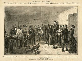
Showman can have a variety of meanings, usually by context and depending on the country.

<span class="mw-page-title-main">Little Clarendon Street</span> Street in Oxford, England

Little Clarendon Street is a short shopping street in northwest Oxford, England. It runs east-west between the south end of Woodstock Road opposite St Giles' Church to the east, Somerville College to the north and Walton Street to the west. One of the three principal streets in North Oxford off the Woodstock Road, the shops and cafés located there are considered bohemian; the other two streets are North Parade and South Parade. Occasionally nicknamed Little Trendy Street, its reputation was already apparent in the 1960s.

<span class="mw-page-title-main">Deddington</span> Human settlement in England

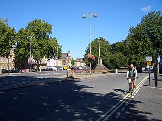
Deddington is a civil parish and small town in Oxfordshire about 6 miles (10 km) south of Banbury. The parish includes two hamlets: Clifton and Hempton. The 2011 Census recorded the parish's population as 2,146. Deddington is a small settlement but has a commercial centre including a market place, which hosts a popular monthly farmer’s market. It has been a market town probably since the 12th century. One of the Hundred Rolls of King Edward I from 1275–76 records Deddington as a borough. It has a deli, coffee shop, restaurant, three pubs and a town hall. Its football team is called Deddington Town FC.

<span class="mw-page-title-main">North Oxford</span> Human settlement in England

North Oxford is a suburban part of the city of Oxford in England. It was owned for many centuries largely by St John's College, Oxford and many of the area's Victorian houses were initially sold on leasehold by the College.

<span class="mw-page-title-main">Banbury Road</span> Arterial road in Oxford, England

Banbury Road is a major arterial road in Oxford, England, running from St Giles' at the south end, north towards Banbury through the leafy suburb of North Oxford and Summertown, with its local shopping centre. Parallel and to the west is the Woodstock Road, which it meets at the junction with St Giles'. To the north, Banbury Road meets the Oxford Ring Road at a roundabout. The road is designated the A4165. Prior to the building of the M40 motorway extension in 1990, the road formed part of the A423 from Maidenhead to Coventry.

<span class="mw-page-title-main">Summertown, Oxford</span> Human settlement in England

Summertown in North Oxford is a suburb of Oxford, England. Summertown is a one-mile square residential area, north of St Giles, the boulevard leading out of Oxford's city centre. Summertown is home to several independent schools and the city's most expensive houses. On both sides of Banbury Road are Summertown's popular shops. There is also a smaller street of shops and restaurants, South Parade, that links Banbury Road and Woodstock Road. Summertown is home to much of Oxford's broadcast media. BBC Radio Oxford and the BBC Television's Oxford studios are on Banbury Road. Start-ups also have an increasing presence on the parade, such as Brainomix and Passle. The studios for JACK FM, Glide FM, and Six TV Oxford are on Woodstock Road.

<span class="mw-page-title-main">Woodstock Road, Oxford</span> Road in Oxford, England

Woodstock Road is a major road in Oxford, England, running from St Giles' in the south, north towards Woodstock through the leafy suburb of North Oxford. To the east is Banbury Road, which it meets at the junction with St Giles'.

<span class="mw-page-title-main">St Giles', Oxford</span> Wide boulevard in central Oxford, UK

St Giles' is a wide boulevard leading north from the centre of Oxford, England. At its northern end, the road divides into Woodstock Road to the left and Banbury Road to the right, both major roads through North Oxford. At the southern end, the road continues as Magdalen Street at the junction with Beaumont Street to the west. Also to the west halfway along the street is Pusey Street. Like the rest of North Oxford, much of St Giles' is owned by St John's College.

<span class="mw-page-title-main">Beaumont Street</span> Street in central Oxford, England

Beaumont Street is a street in the centre of Oxford, England.

<span class="mw-page-title-main">Magdalen Street</span> Street in central Oxford, England

Magdalen Street is a short shopping street in central Oxford, England, just north of the original north gate in the city walls. Traditionally, the name of the street is pronounced and not as the name of the Magdalen College, which is always.

<span class="mw-page-title-main">Walton Street, Oxford</span> Street in central Oxford, England

Walton Street is on the eastern edge of the Jericho district of central Oxford, England.

<span class="mw-page-title-main">St Giles' Church, Oxford</span> Church in Oxford, United Kingdom

St. Giles' Church is a church in North Oxford, England. It is at the northern end of the wide thoroughfare of St Giles', at the point where it meets Woodstock Road and Banbury Road. It stands between where Little Clarendon Street joins Woodstock Road and Keble Road joins Banbury Road.

<span class="mw-page-title-main">Hull Fair</span> European travelling funfair

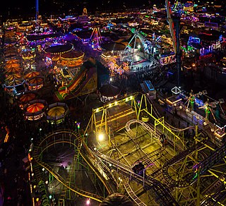
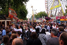
Hull Fair is Europe's largest travelling funfair, which comes to Kingston upon Hull, England for one week from 5 pm on Friday to 11 pm of the Saturday eight days later, encompassing 11 October each year. The fair is open every day between these days except Sunday. Unlike small local fairs, Hull Fair attracts rides, attractions, and travellers from a wide variety of different regions from around the country.

<span class="mw-page-title-main">The Whip (ride)</span> Amusement ride

The Whip was a ride originally designed and built by W.F. Mangels Company of Coney Island, New York, United States. William F. Mangels patented the ride in 1914 and it soon became extremely popular.

Scottish Travellers, or the people in Scotland loosely termed Romani persons or travellers, consist of a number of diverse, unrelated communities that speak a variety of different languages and dialects that pertain to distinct customs, histories, and traditions.

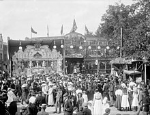
The Showmen's Guild of Great Britain exists to protect the interests of Travelling Showmen in Great Britain.

<span class="mw-page-title-main">City of Oxford Tramways Company</span>

The City of Oxford and District Tramway Company and its successor the City of Oxford Electric Traction Company operated a horse-drawn passenger tramway service in Oxford between 1881 and 1914. The tramway was unusual for having a track gauge of only 4 feet (1.219 m).

<span class="mw-page-title-main">Oxford War Memorial</span>

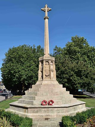
Oxford War Memorial is a first world war memorial in Oxford, at the north end of St Giles', on the junction where the road splits into the A4144 Woodstock Road and the A4165 Banbury Road. The memorial stands in St Giles Memorial Garden, about 150 m (490 ft) to the south of St Giles' Church, Oxford. It was unveiled in 1921 and became a Grade II listed structure in 2016. The Grade II* listed Martyrs' Monument stands about 350 m (1,150 ft) south, at the other end of St Giles'.

References

  1. St. Giles' fair, The Oxford Guide.
  2. 1 2 3 4 Petch, Alison. "Calendar related artefacts: St Giles Fair". England: The Other Within. Pitt Rivers Museum.
  3. 1 2 3 Oxford St. Giles Archived 21 August 2009 at the Wayback Machine , National Fairground Archive, The University of Sheffield
  4. Leslie Wood, St Giles' Oxford: Yesterday and Today — The Story of the Parish of St Giles' Archived 2013-01-13 at archive.today , June 1974.
  5. The Story of St. Giles and the Show, National Fairground Archive, The University of Sheffield, UK.
  6. St Giles' Fair Archived 11 September 2012 at archive.today , St Giles' Church.
  7. St Giles' Fair Archived 2006-05-22 at the Wayback Machine , Oxford History Archived 2006-05-15 at the Wayback Machine .
  8. "'Wholly inappropriate': Outrage as St Giles' Fair appears to offer free rides to 'topless girls'". Oxford Mail . Retrieved 7 September 2022.

Coordinates: 51°45′29″N1°15′36″W / 51.7580°N 1.2601°W / 51.7580; -1.2601