
Castle Hill is a small city of Sydney, New South Wales, Australia, located 34 kilometres north-west of the Sydney central business district and 9.5 kilometres north of Parramatta. It is within the Hills District region, split between the local government areas of The Hills Shire and Hornsby Shire.

Redfern is an inner southern suburb of Sydney located 3 kilometres south of the Sydney central business district and is part of the local government area of the City of Sydney. Strawberry Hills is a locality on the border with Surry Hills. The area experienced the process of gentrification and is subject to extensive redevelopment plans by the state government, to increase the population and reduce the concentration of poverty in the suburb and neighbouring Waterloo.

Richmond is a town in New South Wales, in the local government area of the City of Hawkesbury. It is located 19 metres above sea level on the alluvial Hawkesbury River flats, at the foot of the Blue Mountains on the Cumberland Plain. It is about 65 km by road from Sydney and about 78 km by road from Lithgow.
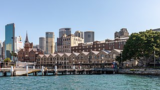
The Rocks is a suburb, tourist precinct and historic area of Sydney's city centre, in the state of New South Wales, Australia. It is located on the southern shore of Sydney Harbour, immediately north-west of the Sydney central business district.

Surry Hills is an inner-east suburb of Sydney, in the state of New South Wales, Australia. Surry Hills is immediately south-east of the Sydney central business district in the local government area of the City of Sydney. Surry Hills is surrounded by the suburbs of Darlinghurst to the north, Chippendale and Haymarket to the west, Moore Park and Paddington to the east and Redfern to the south. It is often colloquially referred to as "Surry".

Ryde is a suburb of Sydney, New South Wales, Australia. Ryde is located 13 km north-west of the Sydney central business district and 8 km east of Parramatta. Ryde is the administrative centre of the local government area of the City of Ryde and part of the Northern Sydney region. It lies on the north bank of the Parramatta River. People from Ryde are colloquially known as Ryders, Rydiens or Rydemen.

Gordon is a suburb on the Upper North Shore of Sydney in the state of New South Wales, Australia 14 kilometres (9 mi) north-west of the Sydney Central Business District and is the administrative centre for the local government area of Ku-ring-gai Council. East Gordon is a locality within Gordon, and West Gordon is a locality within West Pymble.
Randwick is a suburb in the Eastern Suburbs of Sydney, in the state of New South Wales, Australia. Randwick is located 6 kilometres south-east of the Sydney central business district and is the administrative centre for the local government area of the City of Randwick. The postcode is 2031.

Windsor is a historic town north-west of Sydney, New South Wales, Australia. It is the council seat of the Hawkesbury local government area. The town sits on the Hawkesbury River, enveloped by farmland and Australian bush. Many of the oldest surviving European buildings in Australia are located at Windsor. It is 46 kilometres (29 mi) north-west of metropolitan Sydney, on the fringes of urban sprawl.

The Hills Shire is a local government area in the Greater Sydney region of Sydney, New South Wales, Australia. The suburb is north-west of the Sydney central business district, and encompasses 401 square kilometres (155 sq mi) stretching from the M2 Hills Motorway in the south to Wiseman's Ferry on the Hawkesbury River in the north. The Hills Shire had a population of 157,243 as at the 2016 census.

Burwood is a suburb in the Inner West of Sydney, in the state of New South Wales, Australia. It is 10 kilometres (6.2 mi) west of the Sydney central business district and is the administrative centre for the local government area of Municipality of Burwood. People from Burwood are colloquially known as Burwoodiens or Burwooders.

Mortimer William Lewis was an English-born architect, surveyor and public servant who migrated to Australia and became Colonial Architect in the colony of New South Wales from 1835 to 1849. Lewis was responsible for designing and overseeing many government buildings in Sydney and rural New South Wales, many of which are heritage listed.

The St John's Anglican Church, officially known as the Church of St. John the Evangelist, is a heritage-listed active Anglican church located at 120 Darlinghurst Road in the Sydney suburb of Darlinghurst, New South Wales, Australia. The church and its associated buildings were added to the New South Wales State Heritage Register on 2 April 1999. It was also listed on the former Register of the National Estate.

The St Michael's Anglican Church is a church in the Sydney suburb of Surry Hills. It is located on the corner of Albion and Flinders Street and together with the adjoining rectory and parish hall it is listed on the Register of the National Estate. In 2015 the church merged with Vine Church, which was an Anglican church plant that had started in Surry Hills in 2011. In 2017, the church changed its name to Vine Church to reflect the renewal the church has undergone and the life, love and freedom which are on offer to those who connect to Jesus.

St Thomas' Anglican Church is a heritage-listed Anglican church located in the western Sydney suburb of Mulgoa in the City of Penrith local government area of New South Wales, Australia. The church forms part of the Diocese of Sydney. It was designed by Reverend Thomas Makinson, first incumbent priest and James Chadley and built from 1836 to 1838 by James Atkinson and William Chisholm. It is also known as St. Thomas Anglican Church and St Thomas Church of England. The property is owned by Anglican Church Property Trust. It was added to the New South Wales State Heritage Register on 2 April 1999.

St Andrew's Anglican Church is a heritage-listed former Anglican church located at South Street, Walcha in the Walcha Shire, New South Wales, Australia. The site was added to the New South Wales State Heritage Register on 2 April 1999.

St Andrew's Anglican Church is a heritage-listed former Anglican church complex and now private residence at 313 Seven Hills Road, Seven Hills, City of Blacktown, Sydney, New South Wales, Australia. It was designed by G. H. Stoker, and built by Stoker from 1863 to 1892. It is also known as St. Andrew's Anglican Church, Hall & Rectory, St Andrew's and St Andrews. The property is privately owned. It was added to the New South Wales State Heritage Register on 2 April 1999.

St Paul's Anglican Church is a heritage-listed former Anglican church building and former bookshop at 346 Marsden Road, Carlingford, City of Parramatta, Sydney, New South Wales, Australia. It is also known as St Paul's Church of England and The Old Church Bookshop. It was added to the New South Wales State Heritage Register on 2 April 1999.


