
Westminster is a district in Central London, part of the wider City of Westminster.

William Butterfield was a Gothic Revival architect and associated with the Oxford Movement. He is noted for his use of polychromy.

The Metropolitan Borough of Chelsea was a metropolitan borough of the County of London between 1900 and 1965. It was created by the London Government Act 1899 from most of the ancient parish of Chelsea. It was amalgamated in 1965 under the London Government Act 1963, with the Royal Borough of Kensington to form the Royal Borough of Kensington and Chelsea.
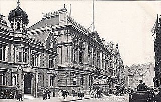
The Metropolitan Borough of Kensington was a Metropolitan borough in the County of London from 1900 to 1965, which since 1901 was known as the Royal Borough of Kensington, following the death of Queen Victoria, in accordance with her wishes.
Ladbroke Grove is an area and a road in West London in the Royal Borough of Kensington and Chelsea, running north–south between Harrow Road and Holland Park Avenue.

Thomas Allom was an English architect, artist, and topographical illustrator. He was a founding member of what became the Royal Institute of British Architects (RIBA). He designed many buildings in London, including the Church of St Peter's and parts of the elegant Ladbroke Estate in Notting Hill. He also worked with Sir Charles Barry on numerous projects, most notably the Houses of Parliament, and is also known for his numerous topographical works, such as Constantinople and the Scenery of the Seven Churches of Asia Minor, published in 1838, and China Illustrated, published in 1845.

St George Hanover Square was a civil parish in the metropolitan area of London, England. The creation of the parish accompanied the building of the St George's Hanover Square Church, constructed by the Commission for Building Fifty New Churches to meet the demands of the growing population. The parish was formed in 1724 from part of the quite early medieval parish of Saint Martin in the Fields in the consequent Liberty of Westminster, hundred of Ossulstone and county of Middlesex. It included some of the most fashionable areas of the West End of London, including Belgravia and Mayfair. Civil parish administration, known as a select vestry, was dominated by members of the British nobility until the parish adopted the Vestries Act 1831. The vestry was reformed again in 1855 by the Metropolis Management Act. In 1889 the parish became part of the County of London and the vestry was abolished in 1900, replaced by Westminster City Council. The parish continued to have nominal existence until 1922. As created, it was a parish for both church and civil purposes, but the boundaries of the ecclesiastical parish were adjusted in 1830, 1835 and 1865.

Little Holland House was the dower house of Holland House in the parish of Kensington, Middlesex, England. It was situated at the end of Nightingale Lane, now the back entrance to Holland Park and was demolished when Melbury Road was made. Number 14 Melbury Road marks its approximate location.

The Tabernacle is a Grade II-listed building in Powis Square, Notting Hill, west London, England, built in 1887 as a church. The building boasts a curved Romanesque façade of red brick and terracotta, and towers with broach spires on either side. Today the Tabernacle serves as a cultural arts and entertainment venue, including a theatre, meeting rooms, music studio, art gallery, bar and kitchen, conservatory and a garden courtyard.
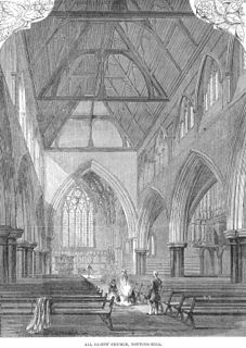
All Saints Notting Hill is a Church of England parish church in Talbot Road, Notting Hill, London. It is a Victorian Gothic Revival stone building with polychromatic decoration. The west tower has five stages with the stump of a spire, and the chancel has paintings by Henry Holiday.

The Royal Crescent is a Grade II* listed street in Holland Park, west London, England, consisting of two curved facing terraces in a crescent shape. The crescent is located on the north side of Holland Park Avenue, west of Addison Avenue, and to the east of the Holland Park Roundabout.

St John's Notting Hill is a Victorian Anglican church built in 1845 in Lansdowne Crescent, Notting Hill, London, designed by the architects John Hargrave Stevens (1805/6–1857) and George Alexander (1810–1885), and built in the Victorian Gothic style. Dedicated to St John the Evangelist, the church was originally built as the centrepiece of the Ladbroke Estate, a mid nineteenth century housing development designed to attract upper- and upper middle-class residents to what was then a largely rural neighbourhood in the western suburbs of London.

The Kensington Hippodrome was a racecourse built in Notting Hill, London, in 1837, by entrepreneur John Whyte. Whyte leased 140 acres (0.57 km2) of land from James Weller Ladbroke, owner of the Ladbroke Estate, and proceeded to enclose "the slopes of Notting Hill and the meadows west of Westbourne Grove" with a 7-foot (2.1 m) high wooden paling. The race course was not a financial success and it closed in 1842, the land being developed soon afterwards, as Ladbroke began building crescents of houses on Whyte's former race course.

The Ladbroke Estate was a substantial estate of land owned by the Ladbroke family in Notting Hill, London, England, in the early 19th century that was gradually developed and turned into housing during the middle years of the century, as London expanded. Characterized by terraces of stuccoed brick houses backing onto large private garden squares, much of the original building remains intact today, and now forms the heart of one of London's most expensive and fashionable neighbourhoods.

St Martin-in-the-Fields was a civil parish in the metropolitan area of London, England. It took its name from the church of St Martin-in-the-Fields and was within the Liberty of Westminster. It included within its boundaries the former extra-parochial areas of Buckingham Palace and St James's Palace.

Royal Borough of Kensington and Chelsea Cemetery, Hanwell is located on the north side of the Uxbridge Road in Hanwell, London, England.

Powis Square is a garden square and locality in Notting Hill, in the Royal Borough of Kensington and Chelsea in London, England. The closest London Underground station to the square is Westbourne Park tube station.

St James' Church, Norlands, is a historic listed church in London, United Kingdom. It is affiliated with the Church of England. It was designed by architects Lewis Vulliamy and Robert Jewell Withers, and its construction was completed in 1845. The church was consecrated on 17 July of the same year. It is listed as Grade II by English Heritage.
Charles Henry Blake (1794–1872) was a British indigo planter and industrialist in India, who became a property developer and railway company director in London.


