
The Maryland Transit Administration (MTA) is a state-operated mass transit administration in Maryland, and is part of the Maryland Department of Transportation. The MTA operates a comprehensive transit system throughout the Washington-Baltimore metropolitan area. There are 80 bus lines serving the Baltimore Metropolitan Area, along with rail services that include the Light Rail, Metro Subway, and MARC Train. In 2023, the system had a ridership of 52,922,000, or about per weekday as of the fourth quarter of 2023.
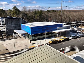
BWI Rail Station is an intermodal passenger station in Linthicum, Maryland near Baltimore/Washington International Airport (BWI). It is served by Amtrak Northeast Corridor intercity trains, MARC Penn Line regional rail trains, and several local bus lines.

Interstate 395 (I-395) is an auxiliary Interstate Highway in the US state of Maryland. Known as Cal Ripken Way, the highway runs 1.98 miles (3.19 km) from I-95 north to Howard Street and Camden Street in Downtown Baltimore, where it provides access to the Inner Harbor and the Baltimore Convention Center. The Interstate also serves the Camden Yards Sports Complex, which contains M&T Bank Stadium and Oriole Park at Camden Yards, homes of the Baltimore Ravens and Baltimore Orioles, respectively. I-395 also serves as the southern terminus of Martin Luther King Jr. Boulevard, an urban arterial that provides a western bypass of Downtown Baltimore and connects I-95 with U.S. Route 40 (US 40), US 1, and I-83. The Interstate is maintained by the Maryland Transportation Authority (MDTA) and, like all Interstates, is a part of the National Highway System.

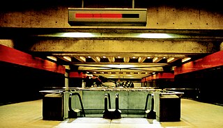
The Baltimore Metro SubwayLink is a rapid transit line serving Baltimore, Maryland, and its northwestern suburbs, operated by the Maryland Transit Administration. The segment in Downtown Baltimore is underground, while most of the line outside the central city is elevated or at surface grade. In 2023, the line had a ridership of 1,988,300, or about 7,953 per weekday as of the fourth quarter of 2023.

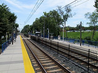
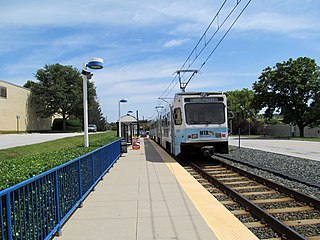
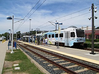
The Baltimore Light RailLink is a light rail system serving Baltimore, Maryland, United States, and its northern and southern suburbs. It is operated by the Maryland Transit Administration. In downtown Baltimore, it uses city streets. Outside the central portions of the city, the line is built on private rights-of-way, mostly from the defunct Northern Central Railway, Baltimore and Annapolis Railroad and Washington, Baltimore and Annapolis Electric Railway. The system had a ridership of 3,546,300, or about 12,500 per weekday, as of the fourth quarter of 2023.
The Red Line is a proposed east–west transit line for Baltimore, Maryland. The original project was granted federal approval to enter the preliminary engineering phase and the Maryland Transit Administration had spent roughly $300 million in planning, design and land acquisition, until Maryland Governor Larry Hogan declared his intent to not provide state funds for the project and shift state funding to roads in suburban areas. The original Red Line had been projected to cost roughly $1.6 billion, $900 million of which would have been guaranteed federal funding. Its construction had been estimated to begin in late 2015–early 2016, subject to funding, with a completion date set for late 2021–early 2022.

Mt. Washington station is a Baltimore Light RailLink station in the Mount Washington neighborhood of northern Baltimore, Maryland. The station has two side platforms serving two tracks.

Camden Station, now also referred to as Camden Street Station, Camden Yards, and formally as the Transportation Center at Camden Yards, is a train station at the intersection of South Howard and West Camden Streets in Baltimore, Maryland, adjacent to Oriole Park at Camden Yards, behind the B&O Warehouse. It is served by MARC commuter rail service and local Light Rail trains.
Fairgrounds station is a Baltimore Light RailLink station located adjacent to the Maryland State Fairgrounds in Timonium, Maryland. The station has two side platforms serving two tracks.
State Center station is an underground Baltimore Metro SubwayLink station in Baltimore, Maryland. It is a transit hub offering connections to the Baltimore Light RailLink system, the tenth most northern and western station on the line, the first one in the area viewed by many as "downtown Baltimore," and is within a 2 block walk of the Cultural Center station on the Light RailLink syste, via Preston Street, and many area landmarks.

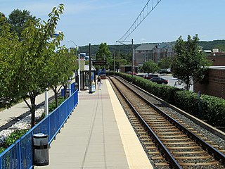
Falls Road station is a Baltimore Light Rail station in the southwest corner of Towson, Maryland, located near the Mount Washington neighborhood of Baltimore and the Bare Hills Historic District in the Jones Falls Valley. It has two side platforms serving two tracks, one in each direction. A 0.3 mile boardwalk provides access from the parking lot to neighboring Lake Roland Park.

Baltimore Arena station is a Baltimore Light RailLink station in Baltimore, Maryland adjacent to the CFG Bank Arena.
Convention Center station is a Baltimore Light Rail station in Baltimore, Maryland. It is located adjacent to the Baltimore Convention Center, and is also near the entrance to Oriole Park at Camden Yards. The Convention Center stop was originally called Pratt Street after the cross street by that name.
McCormick Road station is a Baltimore Light Rail station located in an industrial park in Hunt Valley, Maryland. It is named after the adjacent road, itself named for McCormick & Company, whose offices are nearby. The station was opened in 1997 as part of the system's northern extension. It has a single side platform serving a single track.
Pepper Road station is a Baltimore Light Rail station located in an industrial park in Hunt Valley, Maryland. The station opened in 1997 as part of the system's northern extension. It has a single side platform serving a single track.
Hunt Valley station is a Baltimore Light Rail station located at the Hunt Valley Towne Centre shopping complex in Hunt Valley, Maryland. The station opened in 1997 as the terminus of a northern extension of the Light Rail system. It has a single island platform serving two tracks, which continue east of the platform as tail tracks.

Mt. Royal/MICA station is a Baltimore Light RailLink station in Baltimore, Maryland. It is on the northwest edge of the University of Baltimore campus and on the northern edge of the MICA campus, across Mount Royal Avenue from the site of Baltimore & Ohio Railroad's former Mount Royal Station. It opened in 1992 as part of the line's initial operating segment. The station's construction was funded by the University of Baltimore for the use of its students after the State of Maryland proposed its elimination from the plan to reduce costs.

Cultural Center station is a Baltimore Light RailLink station located along Howard Street in the Mount Vernon neighborhood of Baltimore, Maryland, adjacent to the Joseph Meyerhoff Symphony Hall. It has two side platforms served by two tracks. The station opened on April 2, 1992, as part of the first phase of the system.

Lexington Market station is a Baltimore Light RailLink station adjacent to Lexington Market in Baltimore, Maryland. The station has two side platforms on the sidewalks of Howard Street. Lexington Market station on the Baltimore Metro SubwayLink is located one block to the west.

Cold Spring Lane station is a light rail station on the Baltimore Light Rail system. The stop is located on Cold Spring Lane near the interchange with Interstate 83. The station has two side platforms serving two tracks.

